Area Overview for Great Easton (Uttlesford)
Photos of Great Easton (Uttlesford)
Area Information
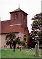
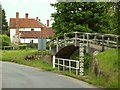
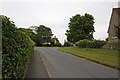
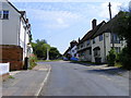
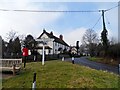
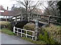
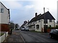
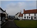
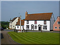
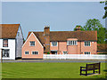
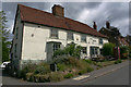
Great Easton is a rural civil parish in the Uttlesford district of Essex, covering 44.3 hectares of land. The area sits approximately two miles north of Great Dunmow, positioned at an elevation of 81 metres above sea level. This built-up area forms part of a primarily rural landscape characterised by intensively cultivated arable farmland. Much of the village lies on higher ground, offering views along the River Chelmer valley. The community retains significant historical depth, with the village dating back to the 12th century. Historic records mention the settlement from Norman times as Easton at the Mount, referencing a mound near Easton Hall. This mound is believed to be the remains of a pre-Roman, Saxon, or Norman motte-and-bailey castle. Residents experience a distinct environment where much of the village is designated as a Conservation Area. This status protects the local architectural heritage and landscape. The parish includes 87 listed buildings, forty of which date from 1600 or earlier. This high concentration of historic structures defines the local character. The area feels distinctly separate from nearby places, distinguished by a historic mound near its church. Living in Great Easton means you inhabit a space where modern life blends with a preserved 12th-century village core. The specific geography of higher ground and arable surroundings creates a quiet, open atmosphere for those prioritising a rural setting.
- Area Type
- Built Up Area 250
- Area Size
- 44.3 hectares
- Population
- Not available
- Population Density
- Not available
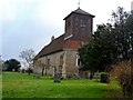
Living in Great Easton offers access to a range of retail and transport amenities within practical reach. For everyday shopping needs, five retail venues are located nearby. You can find supermarkets such as Tesco Dunmow, Co-op Dunmow, and Tesco Takeley. These locations provide comprehensive options for groceries and daily essentials without the need to travel far outside the parish. Transport links further enhance the lifestyle by offering convenient access to major hubs. Three rail stations serve the local area, including Stansted Airport Railway Station, Elsenham Railway Station, and Stansted Mountfitchet Railway Station. These stations connect residents to the commuter rail network. Additionally, London Stansted Airport is a notable nearby facility. You can integrate work travel and leisure trips into your daily routine using these stations. The presence of a Grade II listed Church of St John & St Giles also adds cultural interest to your walkable environment. The combination of retail convenience and transport links means you can enjoy a rural lifestyle while remaining connected to wider opportunities in Essex and beyond.
Amenities
Schools
Families living in Great Easton generally have one primary education option close to their homes. The nearest institution is Great Easton Church of England Voluntary Aided Primary School. This school holds an Ofsted rating of good. The rating signals a standard of education that meets government expectations for school performance and behaviour. The current data does not include secondary schools within the immediate vicinity or broader catchment areas. Consequently, residents likely rely on schools in nearby towns such as Great Dunmow or elsewhere in the Uttlesford district for secondary education. The mix of school types currently available is limited, with only one primary school listed in the dataset. This single option serves the local community of approximately 1,040 residents. If you are choosing this location for school education, the Church of England Voluntary Aided Primary School provides a solid foundation. You should verify travel distances to other schools outside Great Easton to ensure they fit your family's needs.
| Rank | School | Type | Entry gender | Ages |
|---|
Explore more schools in this area
Go to Schools tabDemographics
The community in Great Easton presents a very distinct age profile. The median age for the population is 70 years. This figure indicates a resident base comprised largely of older adults. Age data confirms that the typical household member falls into the over-70 bracket. This demographic structure shapes the daily rhythm of the village. While specific data regarding minority ethnic groups or religious affiliations is not included in the provided records, the age distribution remains the clearest indicator of the population's composition. Home ownership stands at an impressive 77% within the area. This high rate suggests that the majority of residents live in their own homes rather than in rental properties. The accommodation types remain unspecified in the current dataset, but the ownership figure points to a stable, long-term community. With hardly any recent diversification in household composition details, the area reflects a traditional settlement pattern. You will find a neighbourhood where most families and individuals have established roots over many years. The lack of younger demographics correlates with these high ownership rates, indicating a settlement that has not seen a significant shift toward transient populations or student housing in recent times.
Household Size
Accommodation Type
Tenure
Ethnic Group
Religion
Household Composition
Age
Household Deprivation
NS-SEC
Explore more demographic insights in this area
Go to Demographics tabPlanning
Planning Constraints
- Crime RiskPremium