Area Overview for Grafham
Photos of Grafham


Area Information
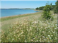
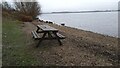
Grafham stands as a distinct civil parish covering 7.3 km² in the English countryside. This specific land size creates a compact, intimate settlement that differs from sprawling urban developments. When you consider living in Grafham, you are entering a space defined by its limited footprint and rural character rather than urban density. The area functions as a tightly knit community where the boundaries of the parish clearly define the extent of daily life. Prospective buyers will find this location offers a contained environment, which appeals to those seeking a specific type of countryside existence without the anonymity of larger towns. The scale of Grafham means that the landscape and infrastructure are directly manageable within this 7.3 km² boundary. You do not need to travel far to navigate the essence of the parish, yet the setting maintains the separation typical of rural England. This geography shapes every aspect of your daily routine, from walking distance to essential services to the overall pace of life. The area represents a singular point in the landscape, offering a defined space for homes in Grafham. Your experience here will be governed by the constraints and benefits of this specific square measurement. There is no ambiguity about the size or scope of the location.
- Area Type
- Parish
- Area Size
- 7.3 km²
- Population
- Not available
- Population Density
- Not available
Demographics
The community within Grafham presents a clear demographic profile, with a median age of 70 years. This figure indicates that the population skews significantly towards older residents, a fact that defines the social fabric of the parish. When you compare this to the most common age range data, the extended population is confirmed, suggesting the area serves as a destination for retirees or those in the senior life stage. Home ownership levels reach 83%, which is an exceptionally high proportion for any residential area in the UK. This statistic means that the vast majority of households own their properties outright or have a significant equity stake. You will find very few rental properties as a result of this ownership dominance. The household composition and accommodation type data reflect a settled population where families have stayed for the long term. There is no transient population disrupting the established residential structure. This stability provides a predictable environment for any new arrival looking to purchase a property. The demographic data paints a picture of a village that has retained its ownership base and demographic character over a long period. Diversity and religion data are noted but the primary defining feature remains the high age bracket and private ownership rates. Living in Grafham means joining a community where the average resident is considerably older than the national average.
Household Size
Accommodation Type
Tenure
Ethnic Group
Religion
Household Composition
Age
Household Deprivation
NS-SEC
Explore more demographic insights in this area
Go to Demographics tabPlanning
Planning Constraints
- Flood RiskPremium
- Ramsar Wetland SitesPremium
- Area of Outstanding Natural BeautyPremium
- Protected Nature ReservePremium
- Crime RiskPremium