Area Overview for Eggington
Photos of Eggington


Area Information
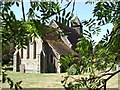
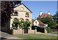
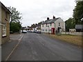
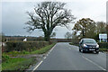
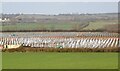
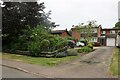
Eggington is a small rural village and civil parish situated in the Central Bedfordshire district of Bedfordshire. It lies approximately three miles east of Leighton Buzzard, occupying an area of 5.3 square kilometres. You will find the village centred around its historic Parish Church of St Michael, which stands as a brick building in the pointed style. The community encompasses the hamlets of Briggington and Clipstone, adding to its traditional footprint. Historically, the name derives from "oak-grown hill," reflecting the elevated terrain found throughout the parish. While the village has seen changes, such as the closure of the local shop and the demolition of the Congregational chapel in the 1970s, it retains a peaceful, low-key atmosphere. Daily life revolves around the village hall and a local Indian restaurant, serving as key social hubs. The former White House parsonage now operates as an elderly care home, indicating the shifting needs of the residents. You are living in an area defined by open clayey soil countryside and quiet streets. This setting suits those seeking a retreat from the urban pace, offering a distinct character away from larger settlements.
- Area Type
- Parish
- Area Size
- 5.3 km²
- Population
- Not available
- Population Density
- Not available
Demographics
The community profile in Eggington reveals a mature population with significant implications for local life. The median age is 70 years old, meaning half of all residents are older than this figure. This data point strongly suggests a neighbourhood dominated by retirees rather than families with young children. Consequently, the social events and local services are likely tailored to an older demographic. The overall house ownership rate stands at 95 per cent, an exceptionally high figure for the region. This statistic indicates that the vast majority of homes in Eggington are owned outright or with a substantial equity stake. You are unlikely to find a large private rental sector here. The low density of the population, with around 190 residents living in 94 houses across the parish, contributes to a static community structure. While there is little data on specific household compositions beyond the total count, the dominance of elderly residents shapes the local culture. Buying here means entering a community where residents have likely lived for decades. The homogeneity of ownership and age creates a stable, if quiet, environment for new homeowners.
Household Size
Accommodation Type
Tenure
Ethnic Group
Religion
Household Composition
Age
Household Deprivation
NS-SEC
Explore more demographic insights in this area
Go to Demographics tabPlanning
Planning Constraints
- Flood RiskPremium
- Ramsar Wetland SitesPremium
- Area of Outstanding Natural BeautyPremium
- Protected Nature ReservePremium
- Protected WoodlandPremium
- Crime RiskPremium