Area Overview for CO9 4ND
Photos of CO9 4ND


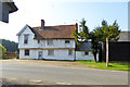


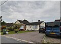


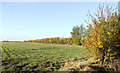

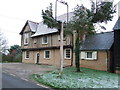
14 photos from this area
Area Information
Key information about the CO9 4ND including its size, population, and administrative classification.
- Area Type
- Postcode
- Area Size
- 65.7 hectares
- Population
- 2217
- Population Density
- 52 people/km²
House Prices in CO9 4ND
8
Properties
£487,900
Average Sold Price
£120,000
Lowest Price
£700,000
Highest Price
Showing 8 properties
| Address | Type | Beds | Baths | Last Sale Price | Last Sale Date | |
|---|---|---|---|---|---|---|
| Farrells, Great Yeldham Road, Stambourne, CO9 4ND | Detached | 5 | 4 | £644,500 | Nov 2023 | |
| Ashfield, Great Yeldham Road, Stambourne, CO9 4ND | Bungalow | 3 | 1 | £625,000 | Sep 2023 | |
| Highfields, Great Yeldham Road, Stambourne, CO9 4ND | Detached | 3 | 3 | £700,000 | Dec 2017 | |
| 1, Greenfields Cottages, Great Yeldham Road, Stambourne, CO9 4ND | house | 3 | - | £350,000 | Sep 2014 | |
| Pound Cottage, Great Yeldham Road, Stambourne, CO9 4ND | Detached | - | - | £120,000 | May 1996 | |
| Mill Farm, Great Yeldham Road, Stambourne, CO9 4ND | Detached | 4 | - | - | - | |
| Greenfields Farm, Great Yeldham Road, Stambourne, CO9 4ND | Farm | - | - | - | - | |
| 2, Greenfields Cottages, Great Yeldham Road, Stambourne, CO9 4ND | Detached | - | - | - | - |
Energy Efficiency in CO9 4ND
Amenities
Schools
| Rank | School | Type | Entry gender | Ages |
|---|
Explore more schools in this area
Go to Schools tabDemographics
Household Size
Two person
most common
Accommodation Type
Houses
most common
Tenure
78
majority
Ethnic Group
White
most common
Religion
N/A
most common
Household Composition
N/A
most common
Age
47
median
Adults (30-64 years)
most common
Household Deprivation
N/A
with no deprivation
NS-SEC
36
in Lower managerial occupations
Explore more demographic insights in this area
Go to Demographics tabPlanning
Planning Constraints
- Flood RiskPremium
- Ramsar Wetland SitesPremium
- Area of Outstanding Natural BeautyPremium
- Protected Nature ReservePremium
- Protected WoodlandPremium