Area Overview for CO7 8LU
Photos of CO7 8LU


Area Information
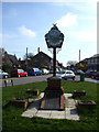
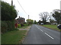
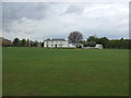
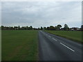
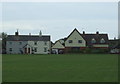
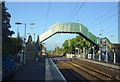
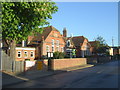
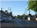
Great Bentley sits as a distinctive civil parish and scattered village within the Tendring district of Essex. Living in the CO7 8LU postcode area means residing in a settlement of approximately 4 hectares, which accommodates a population of 2,516. You will find this location positionates roughly 8 miles southeast of Colchester at coordinates 51.8727703014318, 1.050781463248841. The area historically grew significantly following the arrival of the railway in 1866, when the station was renamed Great Bentley in 1877. This history has shaped a sizable rural village that balances traditional charm with modern commuter appeal. A defining feature of the community is its 43-acre village green, the largest in Britain. This expansive space hosts cricket matches since the late 18th century and various football events. The community features a thriving industrial estate established in the 1960s, which remains active today. Nearby employment centres include the market town of Colchester. The area retains a traditional village atmosphere while benefiting from excellent road, rail, and bus links. Families have enjoyed these historic cricket grounds for generations, and the former Victory Inn once served as the base for Great Bentley Football Club. You will experience a setting where historic wooden clearances from 1135 and the arrival of the train line continue to influence the local character. The postcode covers a small residential cluster that offers direct access to these unique local features.
- Area Type
- Postcode
- Area Size
- 6841 m²
- Population
- 2516
- Population Density
- 192 people/km²
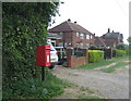
Homes in Great Bentley reflect a specific market characteristic driven by high ownership levels. The data indicates that 84 per cent of households own their properties. This percentage creates a distinct owner-occupied market rather than a rental-heavy environment. You will find the accommodation type centres on Houses, which suits the rural village layout. This housing stock supports a lifestyle away from high-density urban living. The specific postcode CO7 8LU covers a small residential cluster, indicating a limited supply of individual properties available for purchase. The high home ownership figure suggests that new listings may be infrequent as sellers know their neighbours are often long-term residents. The Victorian industrial estate established in the 1960s remains active, offering potential employment or commercial conversion opportunities. Most properties are single-family homes rather than apartments or flats, matching the predominant accommodation type. The area size of 6,841 square metres for the cluster highlights the scarcity of space and the value of individual plots. Buyers should understand that this is not a high-turnover market. The 1960s industrial estate adds utility value to certain land parcels within the parish. The village green of 43 acres is largely communal land, meaning residential plots are surrounded by significant open space. This layout influences property prices and availability compared to denser urban districts near Colchester.
House Prices in CO7 8LU
Showing 10 properties
| Address | Type | Beds | Baths | Last Sale Price | Last Sale Date | |
|---|---|---|---|---|---|---|
| 2 Elm Close, Great Bentley, CO7 8LU | Semi-detached | 3 | 1 | £325,500 | Jan 2025 | |
| 8 Elm Close, Great Bentley, CO7 8LU | Semi-detached | - | - | £155,000 | Mar 2022 | |
| 1 Elm Close, Great Bentley, CO7 8LU | Detached | 3 | - | £237,500 | May 2013 | |
| 3 Elm Close, Great Bentley, CO7 8LU | Semi-detached | - | - | £174,000 | Oct 2007 | |
| 4 Elm Close, Great Bentley, CO7 8LU | house | - | - | £157,000 | Jan 2007 | |
| 5 Elm Close, Great Bentley, CO7 8LU | Semi-detached | - | - | £157,000 | Oct 2006 | |
| 9 Elm Close, Great Bentley, CO7 8LU | house | - | - | £169,500 | Oct 2005 | |
| 6 Elm Close, Great Bentley, CO7 8LU | Semi-detached | - | - | £130,000 | Nov 2002 | |
| 7 Elm Close, Great Bentley, CO7 8LU | Semi-detached | - | - | - | - | |
| 10 Elm Close, Great Bentley, CO7 8LU | house | - | - | - | - |
Energy Efficiency in CO7 8LU
Daily life in Great Bentley offers practical amenities within easy reach of the CO7 8LU cluster. Residents can visit Great Bentley Railway Station, Weeley Railway Station, and Alresford Railway Station for rail travel needs. Local shopping includes a Tesco Great store, a Spar convenience outlet, and an East of England Co-operative Co. These retailers provide essential daily groceries and goods without requiring long drives. The area also features three ferry landing points including Brightlingsea Ferry Landing, Point Clear Ferry Landing, and East Mersea Ferry Landing. These ferry services offer coastal travel options from the village. For leisure, the 43-acre village green provides ample open space for recreation and cricket matches. The former Victory Inn historically served the football club and now functions as a hair salon, reflecting local business evolution. Residents can enjoy the cricket grounds which have hosted matches since the late 18th century. You will find a mix of retail and transport hubs supporting a convenient rural lifestyle. The proximity of five retail outlets and five railway stations ensures minimal travel time for most needs. The East of England Co-operative Co adds variety to the local shopping options. The ferry landings connect the parish to broader coastal networks, enhancing its lifestyle appeal. Living in Great Bentley means accessing these specific named venues for daily errands and leisure.
Amenities
Schools
Families living near Great Bentley have access to primary education within the parish. Great Bentley Primary School serves the local community as a primary institution. This is the only specific school name listed in the available records for immediate access. You will find no secondary schools named directly within the provided data for this postcode cluster. The presence of Great Bentley Primary School indicates a local option for young children before they transfer to out-of-area secondary institutions. Some records list the primary school twice, indicating its significance as the main educational anchor for the civil parish. The singularity of the primary named facility suggests a small catchment area where children from SC7 8LU attend one main facility. Parents must plan for secondary education transfers outside the immediate named school list. The proximity of Great Bentley Primary School supports early years development within the 43-acre village green environs. Children live in a rural setting until they reach the age for broader district allocations. The school list confirms a focus on primary education locally, with secondary options likely located in the wider Tendring district. You should verify secondary placements with the admission authority for the Tendring local authority area beyond the listed primary institution. Great Bentley Primary School remains the definitive named educational provider in the immediate gravel and village context.
| Rank | School | Type | Entry gender | Ages |
|---|
Explore more schools in this area
Go to Schools tabDemographics
The community in Great Bentley presents a clear demographic profile based on precise figures. The median age stands at 47 years, with Adults aged between 30 and 64 years representing the most common age range. This indicates a mature population hub where stability often characterises the neighbourhood. Home ownership is exceptionally high, with 84 per cent of residents owning their property. This figure signals a deeply rooted community rather than a transient rental market. The predominant ethnic group is White, reflecting the area's established rural history. Most residents live in Houses, aligning with the area's description as a civil parish and scattered village. You will find the population density moderate at 192 people per square kilometre. This spread is evident across an area size of 6,841 square metres for the specific cluster at CO7 8LU. The high home ownership rate of 84 per cent suggests that many families have settled here for the long term. The age demographic centered between 30 and 64 years contributes to a stable environment without significant youth or elderly spikes. The absence of significant minority populations aligns with the historic development patterns mentioned in local records. Living in Great Bentley means joining a community defined by these concrete statistical realities rather than shifting trends. The data shows a traditional settlement where residents have strong ties to the land and the railway history.
Household Size
Accommodation Type
Tenure
Ethnic Group
Religion
Household Composition
Age
Household Deprivation
NS-SEC
Explore more demographic insights in this area
Go to Demographics tabPlanning
Planning Constraints
- Flood RiskPremium
- Ramsar Wetland SitesPremium
- Area of Outstanding Natural BeautyPremium
- Protected Nature ReservePremium
- Protected WoodlandPremium