Area Overview for CO7 6PH
Photos of CO7 6PH
Area Information
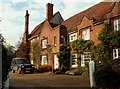
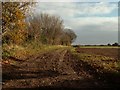
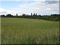
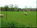
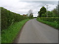
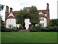
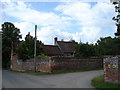
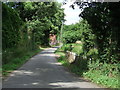
CO7 6PH is a small, tightly knit residential cluster nestled in the heart of rural Suffolk, England. With a population of 1,172 and a density of 67 people per square kilometre, it retains a quiet, village-like character. The area is part of Wenham Magna, a civil parish with a rich medieval history, including its association with Matthew Hopkins, the 17th-century witchfinder general. Residents here benefit from a peaceful, low-density environment, where the landscape is defined by historic hamlets like Gipsy Row and Vauxhall. The parish is dotted with listed buildings, including St John’s Church, a Grade II* site with 14th-century architecture, and Wenham Place, a red-brick manor from the 16th century. Daily life here is shaped by proximity to nature, with minimal urban sprawl, and a strong sense of local heritage. The area’s small size means amenities are limited but practical, with nearby rail links and a handful of local shops. For those seeking a tranquil, historically significant setting, CO7 6PH offers a unique blend of seclusion and cultural depth.
- Area Type
- Postcode
- Area Size
- Not available
- Population
- 1172
- Population Density
- 67 people/km²
The property market in CO7 6PH is dominated by owner-occupied homes, with 83% of properties owned by residents rather than rented. The accommodation type is primarily houses, which is consistent with the area’s rural, low-density character. This suggests a market that caters to those seeking private, spacious living rather than high-density housing. Given the small population and limited land area, the housing stock is likely to be modest in scale, with few new developments. For buyers, this means a niche market where properties are likely to be long-standing and well-established. The focus on owner-occupation also implies a stable market with less turnover. However, the limited size of the area may restrict options for those seeking larger or newer properties, requiring buyers to look further afield for more variety.
House Prices in CO7 6PH
No properties found in this postcode.
Energy Efficiency in CO7 6PH
The lifestyle in CO7 6PH is shaped by its small-scale amenities and proximity to nature. Within practical reach are five retail outlets, including multiple branches of the East of England Co-operative Co, offering essential shopping and services. The area’s rural setting means leisure options are limited to local parks and historical sites, such as the listed buildings of Wenham Magna. The two nearby railway stations provide access to broader regional amenities, though daily life here is centred on close-knit community interactions and a slower pace. The combination of practical retail options and easy rail connectivity creates a balance between self-sufficiency and access to external opportunities. For residents, this means a lifestyle that values tranquillity, heritage, and convenience in a compact, rural environment.
Amenities
Schools
The nearest school to CO7 6PH is Stratford St Mary Primary School, which serves the local community with a good Ofsted rating. This primary school is the only explicitly listed educational institution in the area, meaning families may need to travel further for secondary education. The presence of a good-rated primary school is a positive factor for families with young children, offering a reliable foundation for early education. However, the absence of secondary schools within the immediate vicinity could be a consideration for those planning long-term stays. The school’s rating suggests a focus on quality teaching and facilities, though parents should verify transportation options and catchment areas for secondary schooling.
| Rank | School | Type | Entry gender | Ages |
|---|
Explore more schools in this area
Go to Schools tabDemographics
The community in CO7 6PH is predominantly middle-aged, with a median age of 47 and the majority of residents falling within the 30–64 age range. Home ownership is high, at 83%, reflecting a stable, long-term population. The area is characterised by a focus on houses rather than flats, aligning with its rural, low-density profile. The predominant ethnic group is White, which is typical for small rural parishes in England. The population density of 67 people per square kilometre suggests a spread-out, non-urban settlement pattern. While specific data on deprivation is not provided, the high home ownership rate and age profile indicate a community that prioritises stability over transient living. This demographic profile suggests a place where families and older adults coexist, with limited pressure on local services.
Household Size
Accommodation Type
Tenure
Ethnic Group
Religion
Household Composition
Age
Household Deprivation
NS-SEC
Explore more demographic insights in this area
Go to Demographics tabPlanning
Planning Constraints
- Flood RiskPremium
- Ramsar Wetland SitesPremium
- Area of Outstanding Natural BeautyPremium
- Protected Nature ReservePremium
- Protected WoodlandPremium