Area Overview for CO4 4YJ
Photos of CO4 4YJ


Area Information
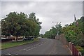
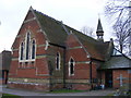
CO4 4YJ is a small residential postcode area in Colchester, Essex, home to around 2,315 people. It lies within the St Anne’s & St John’s Ward, a historic district centred on the ruins of St John’s Abbey, one of the UK’s oldest monastic sites. The area blends modern living with historical roots, with the abbey’s 14th-century gatehouse standing as a key landmark. Daily life here is shaped by its compact size and proximity to Colchester’s town centre, offering a mix of quiet residential streets and easy access to urban amenities. The population is predominantly adults aged 30–64, with a median age of 47, suggesting a community of established residents. While the area is small, it benefits from strong connectivity to nearby services, including retail hubs and rail links. Its low crime risk and flood safety make it an attractive option for those seeking a stable, low-maintenance environment near Colchester’s cultural and commercial heart.
- Area Type
- Postcode
- Area Size
- Not available
- Population
- 2315
- Population Density
- 2783 people/km²
CO4 4YJ is a largely owner-occupied area, with 89% of homes owned by residents rather than rented. The accommodation type is predominantly houses, which is uncommon in more densely populated urban areas but typical of smaller residential clusters. This suggests a community of homeowners invested in long-term stability, with properties likely offering more space and privacy than flats. Given the area’s small size, the housing stock is limited, and buyers should consider the immediate surroundings for additional options. The high home ownership rate also implies a steady demand for properties, potentially supporting property values. However, the lack of rental properties means the market is less dynamic for tenants. For buyers, the focus is on securing a home in a low-risk, low-maintenance environment with strong connectivity to Colchester’s amenities.
House Prices in CO4 4YJ
No properties found in this postcode.
Energy Efficiency in CO4 4YJ
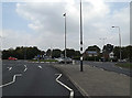
Residents of CO4 4YJ have access to a range of nearby amenities, including retail options such as Tesco Colchester, M&S Colchester Eastwood BP, and other local stores. These shops provide convenience for daily errands, reducing the need to travel further for essentials. The area’s rail stations, including Hythe and Colchester Town, offer easy access to broader regional networks, supporting both commuting and leisure travel. While the data does not list parks or leisure facilities directly, the proximity to Colchester’s town centre suggests access to cultural and recreational options. The presence of retail and transport hubs contributes to a practical, low-maintenance lifestyle, ideal for those prioritising convenience and connectivity. The area’s small size means amenities are closely clustered, enhancing the sense of community and ease of access for residents.
Amenities
Schools
The nearest school to CO4 4YJ is St John’s Church of England Voluntary Controlled Primary School in Colchester, which has an Ofsted rating of ‘good’. This school serves the local community with primary education, offering a structured, faith-based curriculum. While no secondary schools are listed in the data, the presence of a well-rated primary school is a significant draw for families. The school’s location within Colchester ensures accessibility for residents, though parents may need to travel further for secondary education. The mix of school types is limited to primary education here, which means families should investigate nearby secondary options when considering the area. The quality of the primary school, combined with the area’s safety profile, makes it an appealing choice for those prioritising education for younger children.
| Rank | School | Type | Entry gender | Ages |
|---|
Explore more schools in this area
Go to Schools tabDemographics
The population of CO4 4YJ is 2,315, with a median age of 47 and the majority of residents falling within the 30–64 age range. This indicates a mature, settled community, likely with strong family ties and a focus on long-term residency. Home ownership is high at 89%, reflecting a predominantly owner-occupied area rather than a rental market. The accommodation type is primarily houses, which aligns with the area’s residential character and suggests larger properties compared to flats. The predominant ethnic group is White, though no specific diversity statistics are provided. The age profile and ownership rates suggest a community with stable employment and a preference for family homes. With no data on deprivation levels, the focus remains on the area’s established demographic makeup and its alignment with suburban living patterns typical of Colchester.
Household Size
Accommodation Type
Tenure
Ethnic Group
Religion
Household Composition
Age
Household Deprivation
NS-SEC
Explore more demographic insights in this area
Go to Demographics tabPlanning
Planning Constraints
- Flood RiskPremium
- Ramsar Wetland SitesPremium
- Area of Outstanding Natural BeautyPremium
- Protected Nature ReservePremium
- Protected WoodlandPremium