Area Overview for CO16 8RR
Photos of CO16 8RR


Area Information
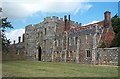
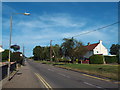
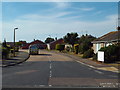
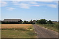
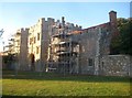
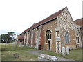
Living in CO16 8RR connects you to a specific residential cluster situated within the historic civil parish of St Osyth in the Tendring District of Essex. This small postcode area covers approximately 3,184 square metres and forms part of a larger village community with a population of roughly 2,798 residents. While the immediate cluster is compact, the broader setting places you just over two miles from the North Sea and on the banks of St Osyth Creek. The location offers a balance between rural character and coastal convenience, positioned about 11 miles northwest of Colchester and 24 km southeast of the city centre. The terrain lies gently at around 10 metres above sea level, reflecting the wider landscape of arable farming and coastal trade that has defined the region since the Domesday Book. You are positioned within a conservation area designated for its architectural interest, where the historic centre features medieval remains and Grade I listed buildings. Daily life here involves proximity to the B1027 road linking Colchester to Clacton-on-Sea, providing straightforward access to wider transport networks without the congestion of a large urban centre. The area represents a quiet, established neighbourhood where the past, preserved through preserved priory ruins and centuries-old churches, lives alongside modern residential needs.
- Area Type
- Postcode
- Area Size
- 3184 m²
- Population
- 1450
- Population Density
- 85 people/km²
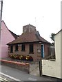
The property market in CO16 8RR reflects a heavily owner-occupied sector, characterised by a market share of 81 per cent for homeownership. This statistic indicates that the vast majority of houses in the postcode are held by resident owners rather than private landlords or institutional investment schemes. The accommodation type is exclusively houses, meaning you will find traditional building styles rather than high-rise flats or purpose-built rental blocks. This housing stock aligns with the historical character of St Osyth, where older properties often feature local architectural details and form part of the conservation area designated in 1969. For buyers searching for homes in CO16 8RR, the market is primarily aimed at owner-occupiers who have the means to purchase rather than tenants seeking affordable rentals. The small area size of 3,184 square metres means supply is limited, likely resulting in competitive viewing opportunities for those with the financial capacity. The dominance of houses suggests that if you view a property in this postcode, it will be a detached or semi-detached dwelling typical of the Essex coastal belt. This lack of mixed tenures creates a uniform community feel, reducing the friction sometimes found in areas with high concentrations of private rental estates.
House Prices in CO16 8RR
Showing 6 properties
| Address | Type | Beds | Baths | Last Sale Price | Last Sale Date | |
|---|---|---|---|---|---|---|
| 2, Priory Court, Chapel Lane, St Osyth, CO16 8RR | Terraced | 2 | 1 | £155,000 | Apr 2023 | |
| Site Of Former Telephone Exchange, Chapel Lane, St Osyth, CO16 8RR | Bungalow | 2 | 1 | £230,000 | Nov 2020 | |
| Chapel House, Chapel Lane, St Osyth, CO16 8RR | house | 4 | - | £415,000 | Jul 2007 | |
| 3, Priory Court, Chapel Lane, St Osyth, CO16 8RR | house | 2 | 1 | £90,000 | Mar 2003 | |
| 1, Priory Court, Chapel Lane, St Osyth, CO16 8RR | Terraced | 2 | - | £52,500 | Mar 1999 | |
| Chapel Cottage, Chapel Lane, St Osyth, CO16 8RR | Terraced | 2 | - | - | - |
Energy Efficiency in CO16 8RR
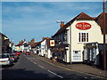
Residents of CO16 8RR enjoy access to a range of amenities within practical reach, supported by three ferry landing sites and several retail locations. You are conveniently situated near Morrisons Daily, Sainsburys Clacton St, and another Morrisons Daily, ensuring that daily shopping needs for groceries and essentials are met without lengthy journeys. Retail options provide a convenient solution for household requirements, while the presence of three ferry landings points to potential leisure opportunities across the creeks at Brightlingsea, Point Clear, and East Mersea. These crossings connect you to the wider Tendring Peninsula, allowing for weekend trips or simple daily commutes to nearby coastal settlements. Public transport links include Clacton, Great Bentley, and Weeley Railway Stations, offering regular services that integrate you into the East Coast rail network. The historical character of the area is visible in the surrounding conservation zone, which lists 112 buildings of historic or architectural interest. You can dine or visit local shops that serve the parish of St Osyth, a community that has traded on the B1027 road for centuries. The nearby St Osyth Priory grounds and the Church of St Peter and St Paul also provide cultural and historical points of interest for leisure. This mix of local retail, water crossings, and rail access creates a lifestyle that balances rural quietness with connectivity to the wider county.
Amenities
Schools
| Rank | School | Type | Entry gender | Ages |
|---|
Explore more schools in this area
Go to Schools tabDemographics
The community within CO16 8RR is defined by an established demographic profile with a median age of 47 years. Most residents fall into the adult range between 30 and 64 years old, indicating a population that has settled down rather than a transient area dominated by students or young families moving for work. Homeownership is the norm, with 81 per cent of the local population owning their properties outright or with a mortgage. This high level of ownership suggests a stable, long-term community where residents often pass down houses to children or upgrade within the same locality as careers progress. The predominant ethnicity in the area is White, consistent with the broader patterns found in many rural coastal villages of east Essex. Accommodation in this postcode cluster consists primarily of houses, fitting the architectural character of the surrounding conservation area. With a population density of 85 people per square kilometre, you live in an area that feels uncrowded yet remains part of a functioning village society. The age profile means local services and amenities cater largely to families and older adults, creating an environment where community ties are likely stronger than in younger, more transient urban locations.
Household Size
Accommodation Type
Tenure
Ethnic Group
Religion
Household Composition
Age
Household Deprivation
NS-SEC
Explore more demographic insights in this area
Go to Demographics tabPlanning
Planning Constraints
- Flood RiskPremium
- Ramsar Wetland SitesPremium
- Area of Outstanding Natural BeautyPremium
- Protected Nature ReservePremium
- Protected WoodlandPremium