Area Overview for CO15 1QP
Photos of CO15 1QP


Area Information
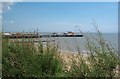
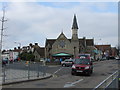
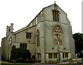
CO15 1QP is a small, densely populated postcode area in Colchester, Essex, covering just 664 square metres. Despite its compact size, it accommodates 1,985 residents, making it one of the most densely populated areas in the UK, with 2,990,538 people per square kilometre. This area is part of the St. James Ward, historically centred on the Grade II* listed St. James the Great Church, a focal point within Colchester’s ancient Roman walls. The ward’s character is shaped by its proximity to this historic site, with the church’s Roman brick foundations and medieval architecture reflecting centuries of local heritage. Daily life here is defined by proximity to retail, transport, and coastal access, with nearby ferry services linking to Brightlingsea and Point Clear. The area’s compact nature means residents are within walking distance of essential services, though its small size also means the community is tightly knit, with a focus on local amenities and historic landmarks.
- Area Type
- Postcode
- Area Size
- 664 m²
- Population
- Not available
- Population Density
- Not available
CO15 1QP is characterised by a rental-dominated property market, with only 33% of homes owned by residents. The accommodation type is predominantly flats, which aligns with the area’s small footprint and high population density. This suggests that the housing stock is largely purpose-built for multi-occupancy, with limited scope for larger family homes. For buyers, this means the area is not a traditional owner-occupied market but rather one where rental properties dominate. The scarcity of owner-occupied homes may make it challenging for first-time buyers to find available properties, though the proximity to transport links and amenities could offset this. Given the area’s size, the immediate surroundings may offer more diverse housing options, but within CO15 1QP itself, buyers should expect a focus on flats and a competitive rental market.
House Prices in CO15 1QP
No properties found in this postcode.
Energy Efficiency in CO15 1QP
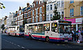
Living in CO15 1QP offers access to a range of local amenities within practical reach. The area is served by five retail outlets, including Morrisons Clacton-on, Iceland Clacton, and Aldi Great Clacton, providing everyday shopping convenience. Nearby railway stations—Clacton, Thorpe, and Kirby Cross—ensure easy access to regional transport networks, while ferry landings at Brightlingsea and Point Clear offer direct coastal connections. These amenities contribute to a lifestyle that balances urban convenience with proximity to natural and cultural attractions. The presence of multiple retail options and transport links suggests a community focused on practicality, with residents able to meet daily needs without long commutes. The area’s historic core, including St. James the Great Church, adds a layer of cultural richness to everyday life.
Amenities
Schools
| Rank | School | Type | Entry gender | Ages |
|---|
Explore more schools in this area
Go to Schools tabDemographics
The population of CO15 1QP has a median age of 47, with the majority of residents falling in the 30–64 age range. This suggests a community of middle-aged adults, many of whom may be professionals or retirees. Home ownership is relatively low at 33%, indicating that a significant portion of the population rents their homes. The predominant accommodation type is flats, reflecting the area’s compact layout and likely high demand for housing in a limited space. The predominant ethnic group is White, though specific diversity metrics are not provided in the data. The high population density—over 2.9 million people per square kilometre—suggests a mix of households, potentially including families and couples. This density may impact local amenities and services, but the area’s proximity to transport and retail could mitigate some of the challenges of living in a densely populated space.
Household Size
Accommodation Type
Tenure
Ethnic Group
Religion
Household Composition
Age
Household Deprivation
NS-SEC
Explore more demographic insights in this area
Go to Demographics tabPlanning
Planning Constraints
- Flood RiskPremium
- Ramsar Wetland SitesPremium
- Area of Outstanding Natural BeautyPremium
- Protected Nature ReservePremium
- Protected WoodlandPremium