Area Overview for CO12 3HJ
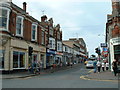
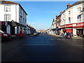
Photos of CO12 3HJ


Area Information
Living in CO12 3HJ means being part of a small, tightly knit residential cluster in the port town of Harwich, Essex. With a population of 1,644, this area reflects Harwich’s historical role as a maritime hub, though today it balances coastal charm with modern convenience. The postcode covers a compact cluster of homes, predominantly houses, reflecting a stable community with strong ties to the surrounding area. Harwich’s strategic location on the River Stour estuary has shaped its character for centuries, from medieval trade routes to its role as a major port. Residents here benefit from proximity to Harwich’s amenities, including its historic Guildhall and St Nicholas Church, while the area’s low population density ensures a quieter, more private lifestyle compared to larger towns. The mix of local governance, from the town council to county-level authorities, underscores the area’s distinct identity. For buyers, CO12 3HJ offers a blend of traditional architecture and practical living, with easy access to transport networks and a community profile skewed towards adults aged 30–64. It is a place where history and modernity coexist, with the port’s economic legacy still evident in local infrastructure and services.
- Area Type
- Postcode
- Area Size
- Not available
- Population
- 1644
- Population Density
- 4237 people/km²
The property market in CO12 3HJ is defined by high home ownership (75%) and a focus on houses, which suggests a market skewed towards owner-occupied properties rather than rentals. This aligns with the area’s character as a residential cluster, where larger homes dominate over flats or apartments. The absence of high-density housing indicates that the market caters to families or individuals seeking private, spacious living rather than urban convenience. For buyers, this means a limited selection of properties, as the area is small and the housing stock is largely established. The proximity to Harwich’s port and transport links may make it appealing to those prioritising location over property choice, though the compact size of the postcode means buyers should consider nearby areas for broader options. The predominance of houses also implies that properties may be more suited to long-term ownership than short-term investment, given their age and construction type.
House Prices in CO12 3HJ
No properties found in this postcode.
Energy Efficiency in CO12 3HJ
Residents of CO12 3HJ have access to a range of amenities within easy reach, including retail outlets such as Asda Harwich, East of England Co-operative Co, and Iceland Dovercourt. These shops provide everyday essentials, reducing the need for long trips to larger centres. The area’s proximity to rail stations and ferry landings enhances its connectivity, making it convenient for both daily commutes and weekend excursions. Harwich’s historic and cultural landmarks, such as the Grade I-listed Harwich Guildhall and St Nicholas Church, add to the area’s character, offering residents a blend of heritage and community life. While the data does not specify parks or leisure facilities, the town’s port-centric economy suggests a focus on coastal activities, which may include walking trails or waterfront access. The combination of practical retail options, transport links, and historical sites contributes to a lifestyle that balances convenience with a sense of place.
Amenities
Schools
The primary school nearest to CO12 3HJ is The Mayflower Primary School, which holds a ‘good’ Ofsted rating. This institution serves the local community, providing education for younger children in the area. The presence of a single primary school suggests that families in CO12 3HJ may rely on this school for their children’s early education, though the absence of secondary schools or additional educational facilities means parents may need to look beyond the immediate postcode for comprehensive schooling. The ‘good’ rating indicates that the school meets national standards in teaching quality and student outcomes, offering a reliable option for families. However, the lack of data on school capacity or waiting lists means prospective buyers should investigate further if school placement is a priority. For those valuing proximity to education, The Mayflower Primary School is a key asset of the area.
| Rank | School | Type | Entry gender | Ages |
|---|
Explore more schools in this area
Go to Schools tabDemographics
The community in CO12 3HJ is predominantly composed of adults aged 30–64, with a median age of 47. This suggests a mature, established population, likely with long-term ties to the area. Home ownership rates are high at 75%, indicating a stable residential base with fewer renters. The accommodation type is primarily houses, which aligns with the area’s character as a residential cluster rather than a high-density suburb. The predominant ethnic group is White, reflecting broader demographic trends in Harwich. While specific data on deprivation is not provided, the high home ownership and low crime risk (88/100) imply a relatively affluent and secure environment. The absence of significant diversity data means the area’s social dynamics are likely homogenous, though this does not necessarily indicate a lack of inclusivity. For families or professionals seeking a settled, low-risk community, CO12 3HJ’s demographic profile offers a predictable, stable backdrop for daily life.
Household Size
Accommodation Type
Tenure
Ethnic Group
Religion
Household Composition
Age
Household Deprivation
NS-SEC
Explore more demographic insights in this area
Go to Demographics tabPlanning
Planning Constraints
- Flood RiskPremium
- Ramsar Wetland SitesPremium
- Area of Outstanding Natural BeautyPremium
- Protected Nature ReservePremium
- Protected WoodlandPremium