Area Overview for CO12 3HD
Photos of CO12 3HD


Area Information
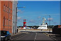
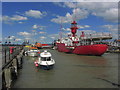
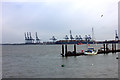
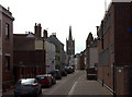
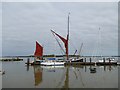
Living in CO12 3HD means being part of a small, tightly knit residential cluster in Harwich, Essex. With a population of 1,324, this postcode area reflects the character of a coastal town shaped by its history as a major port. Harwich’s strategic position on the River Stour estuary has long defined its identity, with maritime trade remaining central to the local economy. The area is part of a broader built-up region with a population of over 20,000, but CO12 3HD itself retains a quiet, residential feel. Daily life here is influenced by proximity to the North Sea coast, with easy access to both land and sea transport. The town’s historic roots are evident in its architecture, including the Grade I listed Harwich Guildhall and medieval sailmaker’s houses. Residents benefit from a mix of practical amenities and a sense of community, though the area’s small size means it is best suited to those seeking a compact, low-maintenance lifestyle.
- Area Type
- Postcode
- Area Size
- Not available
- Population
- 1324
- Population Density
- 5404 people/km²
The property market in CO12 3HD is characterised by a 39% home ownership rate, meaning just over a third of properties are owner-occupied. The majority of homes are houses, which is typical for smaller residential areas with limited high-density development. This suggests a market skewed towards rental properties, with landlords or investors likely holding a significant share of the housing stock. The small size of the postcode area means the housing supply is limited, potentially creating competition among buyers. For those seeking a family home, the prevalence of houses may be advantageous, though the overall scarcity of properties could drive prices upward. Buyers should also consider the area’s proximity to transport links and amenities, which may influence property values. The market appears more suited to long-term residents than to speculative investment, given the lack of large-scale development.
House Prices in CO12 3HD
No properties found in this postcode.
Energy Efficiency in CO12 3HD
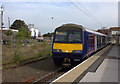
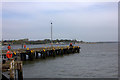
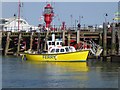
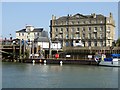
Residents of CO12 3HD have access to a range of practical amenities within easy reach. Local retail options include Iceland Dovercourt, East of England Co-operative Co, and Asda Harwich, providing everyday shopping needs. The area’s rail network, with stations like Harwich International and Dovercourt, connects residents to broader regional transport systems, while ferry services from Harwich Harbour and Felixstowe for Harwich offer maritime links. Though the area is small, its proximity to Harwich’s historic core means residents can also enjoy cultural landmarks such as the parish church of St Nicholas and the Harwich Guildhall. The combination of retail, transport, and heritage sites creates a lifestyle that balances convenience with a touch of coastal character, ideal for those seeking a self-contained yet connected existence.
Amenities
Schools
| Rank | School | Type | Entry gender | Ages |
|---|
Explore more schools in this area
Go to Schools tabDemographics
The community in CO12 3HD is predominantly composed of adults aged 30–64, with a median age of 47. This suggests a mature population, likely with established careers and family ties to the area. Home ownership rates stand at 39%, indicating a mix of owner-occupied properties and rental homes. The accommodation type is primarily houses, reflecting a preference for single-family dwellings over flats or apartments. The predominant ethnic group is White, aligning with broader demographic trends in the region. While no specific deprivation data is provided, the age profile and housing stock suggest a stable, middle-aged population with a focus on long-term residency. The relatively low home ownership rate may indicate a reliance on rental markets or shared housing, though the exact balance between these is not specified.
Household Size
Accommodation Type
Tenure
Ethnic Group
Religion
Household Composition
Age
Household Deprivation
NS-SEC
Explore more demographic insights in this area
Go to Demographics tabPlanning
Planning Constraints
- Flood RiskPremium
- Ramsar Wetland SitesPremium
- Area of Outstanding Natural BeautyPremium
- Protected Nature ReservePremium
- Protected WoodlandPremium