Area Overview for CO12 3BL
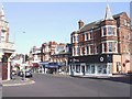
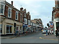
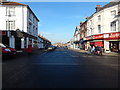
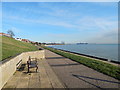
Photos of CO12 3BL


Area Information
CO12 3BL is a small residential postcode area in the port town of Harwich, Essex, home to 1,456 people. Nestled on the North Sea coast, this area benefits from its proximity to the River Stour estuary, a historic maritime hub. The community is characterised by a mature demographic, with a median age of 47 and a majority of residents aged 30–64. Daily life here is shaped by the town’s port heritage, with easy access to ferries, rail services, and local amenities. Harwich’s economy remains tied to its maritime roots, though modern retail and transport options have expanded. The area’s compact size means residents are close to key services, including a primary school with a good Ofsted rating. While the population is relatively small, the postcode reflects a stable, owner-occupied community, with 55% of homes owned by residents. The town’s historic buildings, such as the Grade I-listed Harwich Guildhall, add to its distinct character, blending tradition with practical modern living.
- Area Type
- Postcode
- Area Size
- Not available
- Population
- 1456
- Population Density
- 2709 people/km²
The property market in CO12 3BL is dominated by owner-occupied homes, with 55% of properties owned by residents. This contrasts with areas where rental demand drives the market, indicating a more settled community. The accommodation type is primarily houses, which is typical for a small residential cluster in a coastal town. This suggests a focus on family homes, often with gardens, reflecting the area’s appeal to those seeking space and a slower pace of life. However, the limited size of the postcode means the housing stock is constrained, and buyers may need to consider nearby areas for more options. The market is likely to be competitive for those seeking to purchase within CO12 3BL itself, given its small scale and the appeal of its coastal setting.
House Prices in CO12 3BL
No properties found in this postcode.
Energy Efficiency in CO12 3BL
Life in CO12 3BL is shaped by its coastal location and the availability of nearby amenities. Residents can access five rail stations, including Harwich Town and Dovercourt, which connect to major routes. Retail options include Iceland Dovercourt, East of England Co-operative Co, and Asda Harwich, providing everyday shopping needs. The area’s proximity to ferry services, such as Harwich Harbour and Felixstowe for Harwich, enhances mobility for both leisure and commuting. While the postcode itself is small, the surrounding built-up area of Harwich offers a broader range of services, from historic sites like the Harwich Guildhall to modern retail. The combination of practical transport links and a maritime backdrop creates a lifestyle that balances coastal charm with everyday convenience.
Amenities
Schools
The nearest school to CO12 3BL is Harwich Community Primary School and Nursery, which provides education for younger children. This primary school holds a good Ofsted rating, indicating a satisfactory standard of teaching and facilities. While no secondary schools are listed in the data, the presence of a well-rated primary school suggests the area is suitable for families with young children. The absence of secondary schools nearby may require families to consider commuting to Harwich’s broader built-up area, which includes additional educational institutions. The school’s rating reflects a commitment to quality education, though parents should verify availability of places and transport options for older children.
| Rank | School | Type | Entry gender | Ages |
|---|
Explore more schools in this area
Go to Schools tabDemographics
The population of CO12 3BL is predominantly adults aged 30–64, with a median age of 47. This suggests a community of established professionals and families, many of whom are likely to have lived in the area for several years. Home ownership is strong, with 55% of properties owned by residents, indicating a stable housing market. The accommodation type is primarily houses, reflecting a preference for family homes over flats. The predominant ethnic group is White, aligning with broader trends in the region. While specific data on deprivation is not provided, the high home ownership rate and mature age profile suggest a relatively low dependency on social services. This demographic profile supports a quiet, community-focused lifestyle, with residents likely to prioritise stability and local amenities over urban conveniences.
Household Size
Accommodation Type
Tenure
Ethnic Group
Religion
Household Composition
Age
Household Deprivation
NS-SEC
Explore more demographic insights in this area
Go to Demographics tabPlanning
Planning Constraints
- Flood RiskPremium
- Ramsar Wetland SitesPremium
- Area of Outstanding Natural BeautyPremium
- Protected Nature ReservePremium
- Protected WoodlandPremium