Area Overview for CO12 3AP
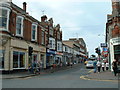
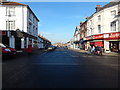
Photos of CO12 3AP


Area Information
Residents of CO12 3AP live within a small residential cluster defined by export postcode CO12 3AP, covering 5,149 square metres. This specific location forms part of Harwich, a historic port town situated on the River Stour estuary in Essex. The area is home to 1,936 people, creating a tight-knit community typical of established coastal parishes. While the immediate geography is compact, the broader context offers access to significant maritime history and modern infrastructure. Harwich itself functions as a major commercial hub, with its economy historically and currently driven by port activities. The local governance structure spans three tiers, including Harwich Town Council and Tendring District Council, reflecting the area's established administrative status. For those considering homes in CO12 3AP, the location offers a blend of residential quiet and proximity to industrial significance. The population density here is notably high relative to the small physical footprint, suggesting a built-up environment rather than open countryside. Living in CO12 3AP means being part of a specific demographic snapshot within the larger civil parish of Harwich, which recorded a population of nearly 19,000 in the 2021 census. This postcode area represents a focused slice of life near the coast, where daily routines are shaped by the town's maritime character.
- Area Type
- Postcode
- Area Size
- 5149 m²
- Population
- 1936
- Population Density
- 3190 people/km²
The housing landscape in CO12 3AP is defined primarily by houses, indicating a stock that aligns with family-oriented living standards. With 46% of households owning their homes, the area presents a mixed economy of owner-occupied and rented properties. This ownership rate places the location in a position wherebuyer competition exists but does not suggest a monopoly of rental stock. Prospective buyers looking at homes in CO12 3AP will find an environment where property turnover is likely driven by life cycle changes among the adult population rather than student accommodation cycles. The predominant ethnicity of White residents and the age profile of 30 to 64 years further suggest that the housing stock caters to practical living needs over niche market demands. Given the small area size of 5,149 square metres, the number of listings is inherently limited, making location within the specific postcode increasingly significant. The fact that 1,936 people currently dwell in this cluster implies that the available housing, while not vast, is sufficient to sustain the local community. Buyers should expect a market reflecting the needs of the established families and retired professionals who make up the bulk of the demographic data.
House Prices in CO12 3AP
Showing 13 properties
| Address | Type | Beds | Baths | Last Sale Price | Last Sale Date | |
|---|---|---|---|---|---|---|
| 186A High Street, Harwich, CO12 3AP | Maisonette | 2 | 1 | £105,000 | Dec 2006 | |
| 107B High Street, Harwich, CO12 3AP | Flat | 3 | - | £18,000 | Mar 1999 | |
| Flat 1, 180 High Street, Harwich, CO12 3AP | Flat | 2 | 1 | - | - | |
| Flat 2, 188 High Street, Harwich, CO12 3AP | Flat | - | - | - | - | |
| Flat 3, 188 High Street, Harwich, CO12 3AP | Flat | - | - | - | - | |
| Flat 4, 188 High Street, Harwich, CO12 3AP | Flat | 1 | - | - | - | |
| Flat, 190 High Street, Harwich, CO12 3AP | undefined | - | - | - | - | |
| Basement Store, 190 High Street, Harwich, CO12 3AP | warehouse | - | - | - | - | |
| Orwell Place Public Toilets, High Street, Harwich, CO12 3AP | Industrial | - | - | - | - | |
| Flat 3, 180 High Street, Harwich, CO12 3AP | Flat | - | - | - | - |
Energy Efficiency in CO12 3AP
Daily life in CO12 3AP offers convenient access to essential amenities located within practical reach of the postcode boundary. Retail options include Iceland Dovercourt, East of England Co-operative Co, and Asda Harwich, providing residents with access to groceries and household goods. Five rail stations operate nearby, including Dovercourt Railway Station, Harwich Town Railway Station, and Harwich International Railway Station, facilitating easy regional travel. Ferry connectivity is also strong, with five landing points serving Felixstowe, Harwich Harbour, and Shotley Point. This transport density ensures that reaching the wider Essex area or Suffolk is straightforward. The presence of multiple retail giants means that daily shopping trips do not require long journeys into central Harwich town centre. Residents can manage weekly food procurement and general shopping efficiently from their doorstep. The integration of rail and ferry services also supports commuting patterns for those working in Ipswich or London. Living in CO12 3AP provides a lifestyle where essential services are immediately accessible without the need for private vehicle dependency for routine tasks.
Amenities
Schools
| Rank | School | Type | Entry gender | Ages |
|---|
Explore more schools in this area
Go to Schools tabDemographics
The community profile for CO12 3AP reflects a mature population, with a median age of 47 years. Most residents fall into the adult bracket between 30 and 64 years old. This age distribution suggests the area attracts families and established professionals rather than students or young singles. Home ownership stands at 46%, indicating a balanced market where nearly half of the households own their properties while the remainder lives in rentals. The predominant accommodation type within CO12 3AP consists of houses, aligning with the traditional character of the surrounding Harwich parish. The population is predominantly White, consistent with the wider demographic trends of the Tendring district. With 1,936 residents living across the postcode, the community maintains a stable size that supports local services without the rapid fluctuations seen in younger, university-owned towns. This stability creates an environment where long-term residents often know their neighbours. The high proportion of home owners contributes to a sense of permanence, distinguishing CO12 3AP from areas dominated by short-term tenancies. Residents in this age group typically require services and amenities suited to families and mature individuals, influencing local demand patterns.
Household Size
Accommodation Type
Tenure
Ethnic Group
Religion
Household Composition
Age
Household Deprivation
NS-SEC
Explore more demographic insights in this area
Go to Demographics tabPlanning
Planning Constraints
- Flood RiskPremium
- Ramsar Wetland SitesPremium
- Area of Outstanding Natural BeautyPremium
- Protected Nature ReservePremium
- Protected WoodlandPremium