Area Overview for CO12 3AA
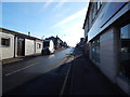
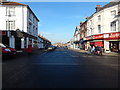
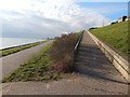
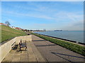
Photos of CO12 3AA


Area Information
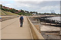
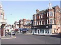
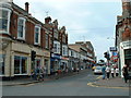
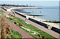
CO12 3AA is a small residential postcode area in Harwich, Essex, nestled on the North Sea coast. Covering just 610 square metres, it is densely populated, with 1,936 residents packed into a compact cluster. Harwich itself is a historic port town with roots stretching back to the 12th century, shaped by its role as a major maritime hub. The area benefits from proximity to key transport links, including rail stations and ferry terminals, which connect residents to nearby towns and beyond. Daily life here is influenced by the town’s port economy, with commercial shipping and trade still central to the local scene. The community is predominantly middle-aged, with a median age of 47, and many residents are homeowners. Despite its small size, CO12 3AA offers a mix of practical amenities, from local shops to public transport, making it a viable choice for those seeking a compact, connected living environment near the coast.
- Area Type
- Postcode
- Area Size
- 610 m²
- Population
- 1936
- Population Density
- 3190 people/km²
The property market in CO12 3AA is dominated by owner-occupied homes, with 46% of residents owning their properties. However, the area is not exclusively a buyers’ market, as 54% of residents are renters, indicating a mix of tenure types. The accommodation type is predominantly houses, which is unusual for a small postcode area but reflects Harwich’s historical development as a residential and maritime hub. This focus on houses may limit availability for those seeking flats or apartments, and the compact size of CO12 3AA means the housing stock is finite. Buyers should consider the area’s small footprint and the potential for limited new developments. The market is likely to cater to those prioritising traditional housing over modern alternatives, with property values influenced by proximity to transport links and the port’s economic activity.
House Prices in CO12 3AA
No properties found in this postcode.
Energy Efficiency in CO12 3AA
Living in CO12 3AA offers access to a range of practical amenities within easy reach. The area is served by five retail outlets, including Iceland Dovercourt and Asda Harwich, providing everyday shopping convenience. Rail connectivity is robust, with Dovercourt Railway Station and Harwich International Station enabling swift travel to nearby towns and cities. Ferry services add to the area’s accessibility, with landings at Harwich Harbour and Shotley Point Marina offering links to other parts of the region. While the postcode itself is small, its proximity to Harwich’s port and historic centres means residents can enjoy the town’s cultural and economic vibrancy. The presence of multiple transport options and local shops supports a self-sufficient lifestyle, with minimal need to travel far for essentials.
Amenities
Schools
| Rank | School | Type | Entry gender | Ages |
|---|
Explore more schools in this area
Go to Schools tabDemographics
The population of CO12 3AA is 1,936, with a median age of 47, indicating a mature community. The most common age range is adults aged 30–64, suggesting a stable demographic with established households. Home ownership stands at 46%, meaning nearly half of residents own their homes, while the remaining 54% are likely to rent. The area is characterised by houses rather than flats, reflecting a traditional housing stock. The predominant ethnic group is White, aligning with broader trends in the region. This demographic profile suggests a community focused on long-term residency, with fewer young families or transient populations. The high population density—3,175,698 people per square kilometre—means the area is tightly packed, which may influence local services and space availability.
Household Size
Accommodation Type
Tenure
Ethnic Group
Religion
Household Composition
Age
Household Deprivation
NS-SEC
Explore more demographic insights in this area
Go to Demographics tabPlanning
Planning Constraints
- Flood RiskPremium
- Ramsar Wetland SitesPremium
- Area of Outstanding Natural BeautyPremium
- Protected Nature ReservePremium
- Protected WoodlandPremium