Area Overview for CO11 2WA
Photos of CO11 2WA
Area Information
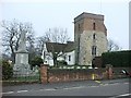
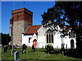
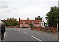
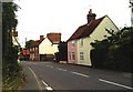
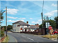
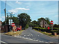
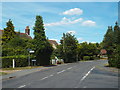
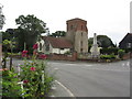
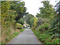
CO11 2WA is a small residential postcode area in Essex, encompassing the village of Bradfield, a rural parish with ancient roots. With a population of 2,427 and a low density of 94 people per square kilometre, it retains a quiet, village-like character. Situated three miles east of Manningtree and nine miles west of Harwich, the area blends historical significance with modern convenience. Bradfield’s history dates to the Neolithic era, with archaeological finds like a Bronze Age macehead and Roman-era artefacts scattered across its heath and fields. Today, the village is defined by its low-rise housing, proximity to rail networks, and a community profile skewed towards adults aged 30–64. Daily life here is shaped by its rural setting, with easy access to nearby towns for employment and amenities, while the postcode’s small size ensures a tight-knit, familiar environment. The area’s charm lies in its balance of heritage and practicality, offering a peaceful alternative to urban centres without sacrificing connectivity.
- Area Type
- Postcode
- Area Size
- Not available
- Population
- 2427
- Population Density
- 94 people/km²
CO11 2WA is an owner-occupied area, with 85% of properties in private hands. The accommodation type is predominantly houses, which is typical for rural and semi-rural postcodes. This suggests a housing stock that prioritises space and privacy over high-density living. The small size of the postcode means the market is limited to a handful of properties, likely concentrated around the village core. For buyers, this presents both opportunities and challenges: the area is unlikely to have a large rental market, and properties may be held by long-term residents. The focus on houses also implies that flats or apartments are rare, which could be a consideration for those seeking alternative housing types. Given the low population density and historical character, property values may reflect the area’s rural appeal, though specific price data is not provided.
House Prices in CO11 2WA
No properties found in this postcode.
Energy Efficiency in CO11 2WA
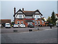
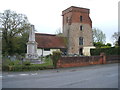
Residents of CO11 2WA benefit from a mix of practical amenities that support daily life. The nearby rail stations, such as Mistley and Manningtree, offer easy access to larger towns, while retail options like Tesco and local co-ops provide essential shopping. The area’s rural character is complemented by its proximity to historical sites, such as St. Lawrence’s Church, which dates back to the 12th century. While there are no named parks or leisure facilities in the data, the presence of Bradfield Heath and the village’s low-density housing suggest open spaces for recreation. The community’s focus on primary education and specialist schools indicates a family-friendly environment, with amenities tailored to residents’ needs. The combination of quiet rural living and accessible services makes CO11 2WA appealing to those seeking a balanced lifestyle.
Amenities
Schools
Residents of CO11 2WA have access to three schools within practical reach. Bradfield Primary School and Wix and Wrabness Primary School both hold Ofsted ratings of ‘good’, offering reliable primary education for local children. Jacques Hall Foundation is a special school, providing tailored support for students with specific needs. The combination of primary and special schools suggests the area caters to a range of educational requirements, from early years to specialist provision. For families, this means proximity to both mainstream and specialist education without the need to travel far. The ‘good’ Ofsted ratings indicate that the primary schools meet or exceed national standards, which is a key factor for parents prioritising quality schooling. The absence of secondary schools in the data means families may need to consider nearby towns like Manningtree for further education.
| Rank | School | Type | Entry gender | Ages |
|---|
Explore more schools in this area
Go to Schools tabDemographics
The population of CO11 2WA is predominantly adults aged 30–64, with a median age of 47. This suggests a community of established professionals and families, rather than a younger or elderly demographic. Home ownership is high at 85%, indicating a stable, long-term resident base. The accommodation type is primarily houses, reflecting a preference for detached or semi-detached properties over flats. The predominant ethnic group is White, though no specific diversity statistics are provided. The absence of data on deprivation or income levels means the area’s quality of life cannot be assessed in those terms, but the high home ownership rate and age profile suggest a relatively affluent, settled population. The mix of primary and special schools nearby also aligns with a family-oriented community.
Household Size
Accommodation Type
Tenure
Ethnic Group
Religion
Household Composition
Age
Household Deprivation
NS-SEC
Explore more demographic insights in this area
Go to Demographics tabPlanning
Planning Constraints
- Flood RiskPremium
- Ramsar Wetland SitesPremium
- Area of Outstanding Natural BeautyPremium
- Protected Nature ReservePremium
- Protected WoodlandPremium