Area Overview for CO11 2UY
Photos of CO11 2UY
Area Information
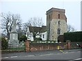
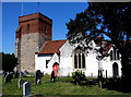
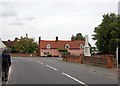
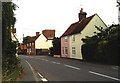
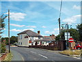
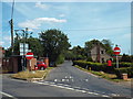
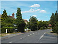
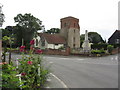
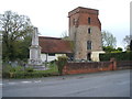
CO11 2UY is a small, rural postcode area in Essex, part of the civil parish of Bradfield, nestled near Manningtree and within reach of Harwich. With a population of 2,427 and a low density of 94 people per square kilometre, this is a quiet, tightly knit community defined by its historical roots and proximity to natural landscapes. The area’s character is shaped by its ancient origins, with evidence of settlement dating back to the Neolithic era. Residents benefit from a mix of rural tranquillity and access to nearby towns, offering a balance of local charm and practical connectivity. Bradfield itself is a village with a distinct identity, marked by landmarks like St. Lawrence’s Church, whose 12th-century tower hints at Anglo-Saxon beginnings. The area’s small size means it feels intimate, with a focus on community and heritage. For those seeking a peaceful, low-density lifestyle without sacrificing access to services, CO11 2UY provides a unique blend of history and modern convenience.
- Area Type
- Postcode
- Area Size
- Not available
- Population
- 2427
- Population Density
- 94 people/km²
The property market in CO11 2UY is dominated by owner-occupied homes, with 85% of residents living in properties they own. This high rate of home ownership suggests a community with long-term residents and a strong emphasis on residential stability. The accommodation type is primarily houses, which is typical for rural areas with lower population density. This indicates that the housing stock is likely to include family homes, detached or semi-detached properties, and fewer flats or apartments. Given the small size of the postcode area, the number of available properties is limited, making it a niche market for buyers seeking a quiet, rural lifestyle. The absence of rental properties means the area is less attractive to investors or those prioritising flexibility. For buyers, this means a focus on established homes rather than new developments, with potential for long-term value retention in a low-risk, stable environment.
House Prices in CO11 2UY
No properties found in this postcode.
Energy Efficiency in CO11 2UY
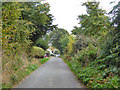
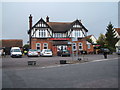
Daily life in CO11 2UY revolves around its small-scale amenities and rural setting. The nearest retail options include Tesco Manningtree and two East of England Co-operative Co branches, providing basic shopping needs. Rail access to Mistley, Wrabness, and Manningtree stations offers connections to nearby towns for more extensive services, dining, and leisure. The area’s historical character, including St. Lawrence’s Church and the War Memorial, adds a sense of heritage to the landscape. While the immediate vicinity lacks large parks or recreational facilities, the surrounding countryside offers opportunities for walking and outdoor activities. The modest amenities reflect the area’s focus on quiet living, with residents relying on nearby towns for more diverse options. This balance of local convenience and rural tranquillity defines the lifestyle for those prioritising a low-key, community-oriented environment.
Amenities
Schools
Residents of CO11 2UY have access to three schools within practical reach. Bradfield Primary School and Wix and Wrabness Primary School both hold Ofsted ratings of ‘good’, offering quality primary education for local children. Jacques Hall Foundation is a special school, providing tailored support for students with specific needs. The mix of primary and special schools suggests a comprehensive educational offering for families, though the absence of secondary schools means students may need to travel to nearby towns like Manningtree or Harwich. The ‘good’ Ofsted ratings for the primary schools indicate reliable standards of teaching and facilities, which is a key consideration for families prioritising education. However, the limited range of school types means parents should factor in additional travel time for secondary education.
| Rank | School | Type | Entry gender | Ages |
|---|
Explore more schools in this area
Go to Schools tabDemographics
The population of CO11 2UY is predominantly adults aged 30–64, with a median age of 47. This suggests a mature, stable community, likely composed of long-term residents and families. Home ownership is high, at 85%, indicating a strong presence of owner-occupied properties rather than rental units. The accommodation type is primarily houses, which aligns with the area’s rural character and lower population density. The predominant ethnic group is White, reflecting the broader demographic patterns of rural Essex. This data points to a community that values stability and property investment, with fewer transient populations. The age profile suggests a focus on family living, with fewer young adults or retirees compared to other areas. The absence of specific deprivation data means the quality of life here is likely tied to the area’s amenities and connectivity, which are modest but functional for local needs.
Household Size
Accommodation Type
Tenure
Ethnic Group
Religion
Household Composition
Age
Household Deprivation
NS-SEC
Explore more demographic insights in this area
Go to Demographics tabPlanning
Planning Constraints
- Flood RiskPremium
- Ramsar Wetland SitesPremium
- Area of Outstanding Natural BeautyPremium
- Protected Nature ReservePremium
- Protected WoodlandPremium