Area Overview for CO11 1AB
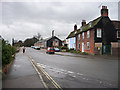
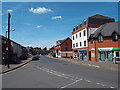
Photos of CO11 1AB


Area Information
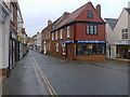
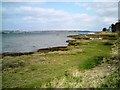
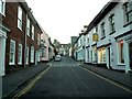
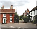
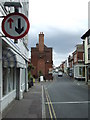
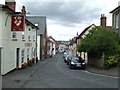
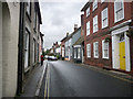
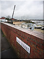
CO11 1AB is a small, densely populated postcode area in Essex, encompassing Manningtree, a historic market town on the River Stour. With a population of 1,683 spread across 961 square metres, the area is characterised by its compact size and high population density of 1,751,736 people per square kilometre. Manningtree’s charm lies in its rural feel, despite its small footprint. As England’s smallest town by land area, it retains a conservation area status, with over 100 Grade II listed buildings and a weekly Saturday market. The town sits at the boundary with Suffolk, within the Suffolk Coast and Heaths Area of Outstanding Natural Beauty. Its historic roots include a Royal Charter from 1238 and ties to the wool trade, though today it serves as a quiet, picturesque community with a focus on heritage. Living here means proximity to natural beauty, a conservation-focused environment, and a tight-knit, older demographic. The area’s compactness means amenities are within practical reach, though its small size also limits expansion. Manningtree’s character is defined by its conservation status, historic architecture, and links to the surrounding AONB, making it a unique blend of rural tranquillity and preserved heritage.
- Area Type
- Postcode
- Area Size
- 961 m²
- Population
- 1683
- Population Density
- 2194 people/km²
The property market in CO11 1AB is dominated by owner-occupied homes, with 62% of residents owning their properties. The predominant accommodation type is houses, which aligns with the area’s character as a small, historic town with a conservation area status. This suggests a limited housing stock, as the area’s size is minimal—just 961 square metres. The high proportion of owner-occupiers indicates a stable market, though the small size of the area may mean competition for available properties. Buyers should consider the compact nature of Manningtree, which may limit options for larger homes or newer developments. The focus on houses rather than flats or apartments reflects the town’s traditional layout and preservation efforts. For those seeking a home in this area, the market is likely to be tight, with properties prioritising historic features and conservation compliance. Proximity to nearby towns and rail links may be key factors for buyers seeking more space beyond the immediate postcode.
House Prices in CO11 1AB
No properties found in this postcode.
Energy Efficiency in CO11 1AB
Living in CO11 1AB offers access to a mix of retail, dining, and transport options within practical reach. The area includes five retail venues, such as Tesco Manningtree and the East of England Co-operative Co, providing everyday shopping needs. Three railway stations—Mistley, Manningtree, and Wrabness—offer direct links to nearby towns and cities, enhancing mobility for commuters or those seeking broader amenities. The town’s character is defined by its historic conservation area, with a weekly Saturday market and a heritage tied to the wool trade and boating. While the data does not specify parks or leisure facilities, the surrounding Suffolk Coast and Heaths AONB suggests opportunities for outdoor activities nearby. The compact nature of the area means amenities are closely clustered, fostering a convenient, if small-scale, lifestyle. Residents can enjoy a mix of historic architecture, local markets, and rail connectivity, all within a setting that prioritises preservation over expansion.
Amenities
Schools
| Rank | School | Type | Entry gender | Ages |
|---|
Explore more schools in this area
Go to Schools tabDemographics
The population of CO11 1AB is 1,683, with a median age of 47, indicating a mature community. The most common age range is adults aged 30–64, suggesting a stable, established population. Home ownership is high at 62%, with houses being the predominant accommodation type. This reflects a community where many residents have long-term ties to the area. The predominant ethnic group is White, though no specific data on diversity or deprivation is provided. The high population density—1,751,736 people per square kilometre—means living spaces are closely packed, which may influence quality of life factors such as noise levels or access to private outdoor space. The age profile suggests a community with a strong presence of middle-aged and older residents, potentially shaping local services and amenities to meet their needs. The lack of data on deprivation or younger demographics means the area’s full demographic picture remains partial, but the existing figures highlight a settled, homeowner-oriented population.
Household Size
Accommodation Type
Tenure
Ethnic Group
Religion
Household Composition
Age
Household Deprivation
NS-SEC
Explore more demographic insights in this area
Go to Demographics tabPlanning
Planning Constraints
- Flood RiskPremium
- Ramsar Wetland SitesPremium
- Area of Outstanding Natural BeautyPremium
- Protected Nature ReservePremium
- Protected WoodlandPremium