Area Overview for CO10 6AD
Photos of CO10 6AD

Area Information
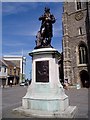
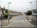
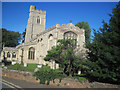
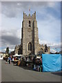
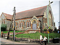
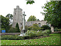
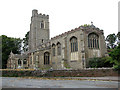
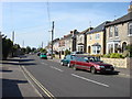
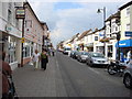
Living in CO10 6AD means being part of a small, tightly knit residential cluster in Suffolk’s Sudbury, a historic market town with roots stretching back to the 10th century. The area’s population of 1,841 reflects its compact nature, with homes primarily in the form of houses rather than flats. Situated near the River Stour, it balances historical charm with modern convenience. Sudbury’s market town heritage is evident in its landmarks, such as the Church of All Saints and Thomas Gainsborough’s birthplace, while nearby transport links, including Sudbury Railway Station, offer connections to Ipswich and London. Daily life here is shaped by a mix of local shops, community-focused amenities, and proximity to both rural tranquillity and accessible urban hubs. The area’s small size means residents often know their neighbours, and the town’s character is defined by its blend of heritage and practicality. For those seeking a quiet, manageable community with historical depth, CO10 6AD offers a distinct alternative to larger urban centres.
- Area Type
- Postcode
- Area Size
- Not available
- Population
- Not available
- Population Density
- Not available
The property market in CO10 6AD is defined by a 44% home ownership rate, suggesting that nearly half of properties are owner-occupied, while the remainder are likely rented. The accommodation type is predominantly houses, which is unusual for a small postcode area but aligns with Sudbury’s historic development as a market town with larger residential plots. This housing stock implies a focus on family homes and single-family living, rather than apartments or shared accommodation. For buyers, this means the area offers a limited but distinct selection of properties, often with traditional features and garden space. However, the small size of the postcode area and its focus on houses may restrict availability, particularly for those seeking newer builds or flats. Prospective buyers should consider the local demand for rental properties, as the lower home ownership rate could indicate a market where landlords play a significant role.
House Prices in CO10 6AD
No properties found in this postcode.
Energy Efficiency in CO10 6AD
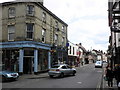
Residents of CO10 6AD have access to a range of amenities within practical reach. Local shops include Waitrose Sudbury, Morrisons Daily, and Iceland Sudbury, providing convenience for grocery shopping and daily essentials. The area’s rail links, such as Sudbury Railway Station, enhance connectivity to nearby towns and cities, supporting both commuting and leisure travel. While specific parks or leisure facilities are not detailed in the data, Sudbury’s historical sites—like the Church of All Saints and Thomas Gainsborough’s birthplace—add cultural value to daily life. The presence of retail outlets and rail services suggests a lifestyle that balances local convenience with broader opportunities. The small postcode area’s compact nature means amenities are closely clustered, reducing the need for long commutes. However, the lack of explicit data on recreational spaces or dining options means residents may need to look slightly further afield for full leisure experiences.
Amenities
Schools
| Rank | School | Type | Entry gender | Ages |
|---|
Explore more schools in this area
Go to Schools tabDemographics
The community in CO10 6AD is predominantly composed of adults aged 30–64, with a median age of 47. This suggests a mature, stable population, likely with established careers and family ties. Home ownership stands at 44%, indicating a mix of owner-occupied properties and rental units. The area is characterised by houses rather than flats, reflecting a preference for traditional, larger homes. The predominant ethnic group is White, aligning with broader regional demographics. While specific data on deprivation is absent, the age profile and home ownership rate imply a community with relatively stable economic conditions. However, the high crime risk score of 11 (a critical level) may impact perceived safety and quality of life. Residents here are likely to value the area’s historical and social cohesion, though they may need to consider security measures given the local crime statistics.
Household Size
Accommodation Type
Tenure
Ethnic Group
Religion
Household Composition
Age
Household Deprivation
NS-SEC
Explore more demographic insights in this area
Go to Demographics tabPlanning
Planning Constraints
- Flood RiskPremium
- Ramsar Wetland SitesPremium
- Area of Outstanding Natural BeautyPremium
- Protected Nature ReservePremium
- Protected WoodlandPremium