Area Overview for CO10 2EL
Photos of CO10 2EL

Area Information
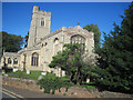
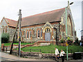
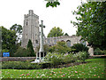
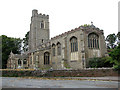
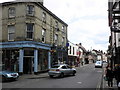
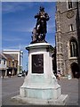
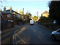
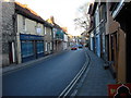
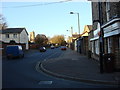
Living in CO10 2EL means being part of a small, tightly knit residential cluster in Suffolk, England. The area covers just 626 square metres, housing 1,841 people in a densely populated setting. Despite its compact size, CO10 2EL sits within Sudbury, a historic market town with roots tracing back to the 10th century. The town’s character is shaped by its proximity to the River Stour and its legacy as a hub for trade and industry. Daily life here blends modern convenience with historical intrigue, from the Church of All Saints to the birthplace of artist Thomas Gainsborough. The area’s high population density—over 2.9 million people per square kilometre—reflects its role as a focused residential node, with amenities and transport links serving a local community that values accessibility and tradition. For buyers, CO10 2EL offers a rare combination of compact living and historical richness, though its limited size means every decision about where to live is intimate and precise.
- Area Type
- Postcode
- Area Size
- 626 m²
- Population
- Not available
- Population Density
- Not available
The property market in CO10 2EL is defined by its small size and focus on houses. With only 44% of homes owned by residents, the area leans more towards rental properties than owner-occupation, suggesting a dynamic where landlords and tenants coexist. The predominance of houses over flats implies a housing stock suited to families or individuals seeking more space, though the compact nature of the postcode means opportunities for expansion are limited. Buyers considering CO10 2EL must navigate a constrained market where every property is closely tied to the town’s historical and geographical context. The immediate surroundings, including Sudbury’s broader area, may offer more options, but proximity to amenities and transport links remains a key selling point. For those prioritising space and tradition, CO10 2EL’s properties reflect a blend of practicality and heritage.
House Prices in CO10 2EL
No properties found in this postcode.
Energy Efficiency in CO10 2EL
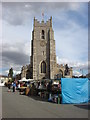
Life in CO10 2EL is shaped by its proximity to essential amenities, including retail and transport hubs. Within practical reach are five retail outlets, such as Morrisons Daily, Iceland Sudbury, and Waitrose Sudbury, offering a range of grocery and convenience shopping options. The area’s rail network, with three stations including Sudbury Railway Station, ensures easy access to regional and national destinations. While the data does not specify parks or leisure facilities, the historical context of Sudbury—home to landmarks like the Church of All Saints and Thomas Gainsborough’s birthplace—suggests a cultural richness that may influence local activities. The compact nature of the postcode means residents are likely to rely on nearby towns for broader leisure options, but the immediate vicinity provides sufficient daily convenience. The blend of practical amenities and historical depth creates a lifestyle that balances modern needs with traditional charm.
Amenities
Schools
| Rank | School | Type | Entry gender | Ages |
|---|
Explore more schools in this area
Go to Schools tabDemographics
The community in CO10 2EL is predominantly middle-aged, with a median age of 47 and the majority of residents falling within the 30-64 age range. This suggests a population skewed toward established professionals and families, rather than younger or older demographics. Home ownership stands at 44%, meaning nearly half of residents rent their homes, indicating a mix of owner-occupied and rental properties. The area is characterised by houses rather than flats, reflecting a preference for single-family dwellings. The predominant ethnic group is White, aligning with broader trends in the region. The high population density—over 2.9 million people per square kilometre—raises questions about living space per person, though the data does not specify deprivation levels. This density may influence local services and infrastructure, but the area’s small size ensures a tightly connected community where social networks are likely to be strong.
Household Size
Accommodation Type
Tenure
Ethnic Group
Religion
Household Composition
Age
Household Deprivation
NS-SEC
Explore more demographic insights in this area
Go to Demographics tabPlanning
Planning Constraints
- Flood RiskPremium
- Ramsar Wetland SitesPremium
- Area of Outstanding Natural BeautyPremium
- Protected Nature ReservePremium
- Protected WoodlandPremium