Area Overview for CM9 5HF
Photos of CM9 5HF


Area Information
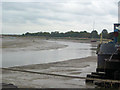
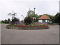
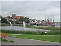
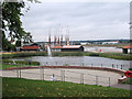
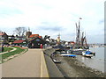
CM9 5HF is a small, tightly packed residential cluster in the historic town of Maldon, Essex. With a population of 1,809 spread across just 1.4 hectares, it is one of the most densely populated areas in England, at 127,000 people per square kilometre. This compact postcode sits on the south bank of the Blackwater Estuary, a location that has shaped Maldon’s identity as a historic market town with Saxon origins. Daily life here is defined by proximity—residents live within walking distance of shops, rail links, and the town’s cultural heritage. The area’s compact size means it is both a microcosm of Maldon’s character and a place where community ties are strong. While the population density is extreme, the area benefits from being part of a town with a rich history, including Saxon-era foundations and a royal charter from 1171. For those seeking a blend of historical significance and modern convenience, CM9 5HF offers a unique, if intensely lived-in, environment.
- Area Type
- Postcode
- Area Size
- 1.4 hectares
- Population
- Not available
- Population Density
- Not available
The property market in CM9 5HF is characterised by a high rate of home ownership (54%) and a focus on houses rather than flats. This suggests a market skewed towards owner-occupied properties, with limited rental availability. Given the area’s small size and high density, the housing stock is likely limited to a few dozen properties, many of which may be older homes reflecting Maldon’s historic character. Buyers should consider that the compact nature of the postcode means competition for properties could be fierce, and the immediate surroundings may offer more options. The predominance of houses over flats may appeal to those seeking traditional, spacious living, though the lack of newer developments could limit choices for those prioritising modern amenities.
House Prices in CM9 5HF
Showing 42 properties
| Address | Type | Beds | Baths | Last Sale Price | Last Sale Date | |
|---|---|---|---|---|---|---|
| 42 Victoria Road, Maldon, CM9 5HF | Semi-detached | 3 | 2 | £370,000 | Aug 2025 | |
| 32 Victoria Road, Maldon, CM9 5HF | house | - | - | £450,000 | Dec 2023 | |
| 24 Victoria Road, Maldon, CM9 5HF | house | - | - | £380,000 | Nov 2022 | |
| 66 Victoria Road, Maldon, CM9 5HF | Bungalow | - | - | £400,000 | Mar 2021 | |
| 22 Victoria Road, Maldon, CM9 5HF | house | - | - | £320,000 | Oct 2018 | |
| 50 Victoria Road, Maldon, CM9 5HF | house | 4 | 2 | £325,000 | May 2018 | |
| Baxters, 46 Victoria Road, Maldon, CM9 5HF | house | 3 | 2 | £410,000 | May 2017 | |
| 62 Victoria Road, Maldon, CM9 5HF | Bungalow | 2 | 1 | £410,000 | Mar 2017 | |
| 60 Victoria Road, Maldon, CM9 5HF | house | - | - | £565,000 | Aug 2016 | |
| 56 Victoria Road, Maldon, CM9 5HF | Semi-detached | 3 | 1 | £288,500 | Jan 2015 |
Energy Efficiency in CM9 5HF
Living in CM9 5HF offers access to a range of local amenities within easy reach. The area is near Iceland Maldon, M&S Maldon SF, and Lidl Heybridge, providing essential shopping and grocery needs. For rail commuters, Hatfield Peverel, Witham, and North Fambridge stations are within a short distance, linking residents to broader regional networks. While the data does not specify parks or leisure facilities, Maldon’s historic character includes sites like St Peter’s Tower and All Saints’ Church, which contribute to the area’s cultural appeal. The compact layout ensures that daily errands and travel are efficient, though the absence of detailed information on recreational spaces means residents may need to travel slightly further for larger leisure activities.
Amenities
Schools
| Rank | School | Type | Entry gender | Ages |
|---|
Explore more schools in this area
Go to Schools tabDemographics
The residents of CM9 5HF are predominantly adults aged 30–64, with a median age of 47. This suggests a community of middle-aged individuals, likely focused on stability and long-term living. Home ownership is high at 54%, indicating that many residents are settled in their properties, which are predominantly houses rather than flats. The predominant ethnic group is White, reflecting the broader demographic trends in the area. The high proportion of owner-occupied homes and the age profile suggest a population that values security and established living. However, the lack of specific data on deprivation or income levels means the full picture of quality of life remains partial. The age range implies a community with active professionals and families, though the absence of younger residents or retirees is notable.
Household Size
Accommodation Type
Tenure
Ethnic Group
Religion
Household Composition
Age
Household Deprivation
NS-SEC
Explore more demographic insights in this area
Go to Demographics tabPlanning
Planning Constraints
- Flood RiskPremium
- Ramsar Wetland SitesPremium
- Area of Outstanding Natural BeautyPremium
- Protected Nature ReservePremium
- Protected WoodlandPremium