Area Overview for CM9 4DB
Photos of CM9 4DB


Area Information
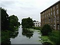
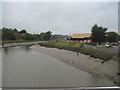
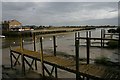
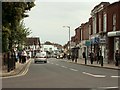
Living in CM9 4DB means residing in a small, densely populated residential cluster within the historic town of Maldon, Essex. The area covers 4,729 square metres and is home to 1,809 people, equating to a population density of 382,500 people per square kilometre. This compact postcode is part of a town with Saxon origins, once a key port and market hub. Daily life here is shaped by its proximity to the Blackwater Estuary and its historical roots, with a mix of modern convenience and heritage. The area’s small size means residents share close proximity to amenities, though the high density could influence community dynamics. Maldon’s status as a historic administrative centre adds cultural depth, with landmarks like St Peter’s Tower and All Saints’ Church nearby. For those seeking a blend of tradition and practicality, CM9 4DB offers a snapshot of a town balancing its past with contemporary living.
- Area Type
- Postcode
- Area Size
- 4729 m²
- Population
- Not available
- Population Density
- Not available
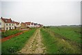
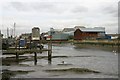
The property market in CM9 4DB is dominated by houses, with 54% of residents owning their homes. This contrasts with areas where rental properties predominate, suggesting a more settled community. The small size of the postcode means the housing stock is limited, with no indication of high-rise or mixed-use developments. Buyers should consider the immediate surrounding areas for more options, as the cluster’s compact nature restricts availability. The high home ownership rate implies a stable market, but the small population and density may limit appreciation potential. For those seeking a family home, the area’s traditional housing and proximity to Maldon’s amenities could be appealing, though buyers must weigh the limited supply against long-term value.
House Prices in CM9 4DB
Showing 17 properties
| Address | Type | Beds | Baths | Last Sale Price | Last Sale Date | |
|---|---|---|---|---|---|---|
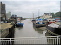
| Churston, Fullbridge Quay, Maldon, CM9 4DB | Detached | 3 | 3 | £595,000 | Feb 2023 | |
| Lapwing House, Fullbridge Quay, Maldon, CM9 4DB | house | - | - | £656,000 | Jan 2022 | |
| Sanderling House, Fullbridge Quay, Maldon, CM9 4DB | house | - | - | £660,000 | Dec 2017 | |
| Grebe House, Fullbridge Quay, Maldon, CM9 4DB | house | - | - | £795,000 | Dec 2016 | |
| Sandpiper House, Fullbridge Quay, Maldon, CM9 4DB | Land | - | - | - | - | |
| Flat 3, The Moorings, Fullbridge Quay, Maldon, CM9 4DB | Flat | - | - | - | - | |
| Flat 8, The Moorings, Fullbridge Quay, Maldon, CM9 4DB | Flat | - | - | - | - | |
| Flat 4, The Moorings, Fullbridge Quay, Maldon, CM9 4DB | Flat | - | - | - | - | |
| Flat 9, The Moorings, Fullbridge Quay, Maldon, CM9 4DB | Flat | - | - | - | - | |
| Mango Accountancy Limited, The Quay House, Fullbridge Quay, Maldon, CM9 4DB | Office | - | - | - | - |
Energy Efficiency in CM9 4DB
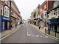
Residents of CM9 4DB have access to essential retail and transport hubs within practical reach. Nearby supermarkets include Lidl Heybridge, Iceland Maldon, and Tesco Maldon, offering daily necessities. The three railway stations—Hatfield Peverel, Witham, and North Fambridge—connect the area to broader networks, facilitating travel to work, leisure, or shopping. While the postcode itself is small, its proximity to Maldon’s historic core provides access to cultural sites like St Peter’s Tower and All Saints’ Church. The compact nature of the area means amenities are concentrated, fostering convenience but potentially limiting variety. For those valuing proximity to services and historical landmarks, CM9 4DB offers a blend of practicality and heritage.
Amenities
Schools
| Rank | School | Type | Entry gender | Ages |
|---|
Explore more schools in this area
Go to Schools tabDemographics
The community in CM9 4DB is predominantly composed of adults aged 30–64, with a median age of 47. This suggests a mature population, likely with established careers and families. Home ownership stands at 54%, indicating a stable residential base, though 46% of properties are rented, reflecting a mix of long-term residents and transient occupants. The area is characterised by houses rather than flats, aligning with a more traditional housing stock. The predominant ethnic group is White, which shapes the social and cultural fabric of the area. With a population density over 380,000 per square kilometre, the community is tightly knit, though this density may impact public services and infrastructure. The age profile implies a focus on middle-aged and older residents, which could influence local amenities and social activities.
Household Size
Accommodation Type
Tenure
Ethnic Group
Religion
Household Composition
Age
Household Deprivation
NS-SEC
Explore more demographic insights in this area
Go to Demographics tabPlanning
Planning Constraints
- Flood RiskPremium
- Ramsar Wetland SitesPremium
- Area of Outstanding Natural BeautyPremium
- Protected Nature ReservePremium
- Protected WoodlandPremium