Area Overview for CM77 7UL
Photos of CM77 7UL

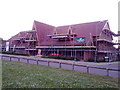
![Great Notley Church [Under Construction ] in CM77 7UL](https://images.propbar.co.uk/images/geograph/17/75/1775130_120.jpg)


26 photos from this area
Area Information
Key information about the CM77 7UL including its size, population, and administrative classification.
- Area Type
- Postcode
- Area Size
- 9680 m²
- Population
- 2279
- Population Density
- 5006 people/km²
House Prices in CM77 7UL
18
Properties
£291,034
Average Sold Price
£109,950
Lowest Price
£515,000
Highest Price
Showing 18 properties
| Address | Type | Beds | Baths | Last Sale Price | Last Sale Date | |
|---|---|---|---|---|---|---|
| 11 Thirlmere Close, Great Notley, CM77 7UL | Retail | 4 | 2 | £515,000 | Nov 2022 | |
| 17 Thirlmere Close, Great Notley, CM77 7UL | Detached | 5 | 2 | £455,000 | Apr 2021 | |
| 12 Thirlmere Close, Great Notley, CM77 7UL | Detached | 4 | 2 | £427,500 | Jul 2020 | |
| 7 Thirlmere Close, Great Notley, CM77 7UL | house | - | - | £285,000 | Jul 2017 | |
| 6 Thirlmere Close, Great Notley, CM77 7UL | Detached | 5 | - | £453,000 | Jan 2017 | |
| 2 Thirlmere Close, Great Notley, CM77 7UL | house | 3 | - | £267,500 | Feb 2015 | |
| 13 Thirlmere Close, Great Notley, CM77 7UL | Detached | 5 | - | £309,000 | Jan 2014 | |
| 15 Thirlmere Close, Great Notley, CM77 7UL | Detached | 4 | - | £250,000 | Jun 2013 | |
| 4 Thirlmere Close, Great Notley, CM77 7UL | Semi-detached | 3 | - | £243,000 | Mar 2013 | |
| 10 Thirlmere Close, Great Notley, CM77 7UL | Detached | - | - | £214,500 | Apr 2006 |
Page 1 of 2
Energy Efficiency in CM77 7UL
Amenities
Schools
| Rank | School | Type | Entry gender | Ages |
|---|
Explore more schools in this area
Go to Schools tabDemographics
Household Size
Family (3-5 people)
most common
Accommodation Type
Houses
most common
Tenure
84
majority
Ethnic Group
White
most common
Religion
N/A
most common
Household Composition
N/A
most common
Age
47
median
Adults (30-64 years)
most common
Household Deprivation
N/A
with no deprivation
NS-SEC
44
in Lower managerial occupations
Explore more demographic insights in this area
Go to Demographics tabPlanning
Planning Constraints
- Flood RiskPremium
- Ramsar Wetland SitesPremium
- Area of Outstanding Natural BeautyPremium
- Protected Nature ReservePremium
- Protected WoodlandPremium