Area Overview for CM5 9NJ
Photos of CM5 9NJ


Area Information
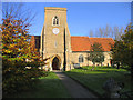
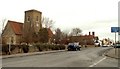
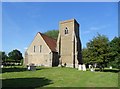
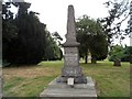
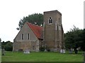
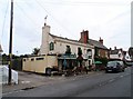
Living in CM5 9NJ means residing in a small, rural postcode area within High Ongar, a civil parish in Essex. With a population of 2,464 spread across 54 people per square kilometre, the area feels quiet and unspoiled, retaining its historical character. The parish includes St Mary’s Church, a medieval site with a 12th-century nave and 13th-century bell tower, and the Nine Ashes pub, a local landmark. Daily life here is shaped by its rural setting, with proximity to Chipping Ongar’s market town heritage and Epping Forest’s natural landscapes. The area’s low population density suggests a community of modest size, where neighbours are likely to know one another. While it lacks the density of urban centres, its charm lies in its historical roots, quiet streets, and easy access to nearby towns like Chelmsford. For those seeking a slower pace of life, CM5 9NJ offers a blend of tradition and practicality, with amenities and transport links within reach.
- Area Type
- Postcode
- Area Size
- Not available
- Population
- 2464
- Population Density
- 54 people/km²
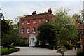
The property market in CM5 9NJ is defined by its high home ownership rate (74%) and a focus on houses rather than flats. This suggests a community where property is primarily owner-occupied, with limited rental activity. The small postcode area implies a constrained housing stock, likely centred on traditional homes rather than modern developments. Buyers should consider the area’s proximity to nearby towns like Chipping Ongar and Chelmsford, which may offer additional property options. The lack of high-density housing means the market is unlikely to cater to large families or those seeking multiple properties. For those prioritising stability and a low-crime environment, CM5 9NJ’s property landscape offers a mix of established homes in a rural setting, though its small size may limit choice for buyers seeking specific features.
House Prices in CM5 9NJ
No properties found in this postcode.
Energy Efficiency in CM5 9NJ
The lifestyle in CM5 9NJ is shaped by its mix of retail, transport, and local venues. Nearby shops include Tesco Ongar, Sainsburys Chipping, and the Chelmsford Star Co-operative Society, offering everyday essentials. The Nine Ashes pub, a historic venue, adds character to the area’s social scene. For travel, Ingatestone and Shenfield railway stations connect residents to broader networks, while North Weald Airport provides regional flight options. Though the area is rural, its amenities are practical, catering to daily needs without requiring long commutes. The presence of a ‘good’-rated primary school and proximity to Epping Forest’s natural landscapes suggest a balance between convenience and tranquillity. This blend of small-town charm and functional connectivity defines the area’s appeal.
Amenities
Schools
The nearest school to CM5 9NJ is High Ongar Primary School, which serves the area with a primary education offering. The school holds an Ofsted rating of ‘good’, indicating a satisfactory standard of teaching and facilities. As the only named school in the data, it is the sole educational institution listed for this postcode. Families relying on this school would need to consider secondary education options in nearby towns, as no secondary schools are mentioned. The presence of a ‘good’-rated primary school suggests a baseline level of educational provision, though parents may need to look beyond CM5 9NJ for comprehensive schooling.
| Rank | School | Type | Entry gender | Ages |
|---|
Explore more schools in this area
Go to Schools tabDemographics
The community in CM5 9NJ is predominantly middle-aged, with a median age of 47 and the most common age range being adults aged 30–64. Home ownership is high, at 74%, and the area is characterised by houses rather than flats or apartments. The predominant ethnic group is White, reflecting the area’s rural and historically homogenous profile. With no data on deprivation or diversity beyond this, the population appears stable and settled. The low population density of 54 people per square kilometre suggests a spread-out, possibly family-oriented community. The age profile indicates a mature demographic, which may influence local services and amenities. This mix of home ownership and age distribution points to a place where long-term residency is common, with fewer transient residents.
Household Size
Accommodation Type
Tenure
Ethnic Group
Religion
Household Composition
Age
Household Deprivation
NS-SEC
Explore more demographic insights in this area
Go to Demographics tabPlanning
Planning Constraints
- Flood RiskPremium
- Ramsar Wetland SitesPremium
- Area of Outstanding Natural BeautyPremium
- Protected Nature ReservePremium
- Protected WoodlandPremium