Area Overview for CM4 9HT
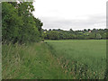
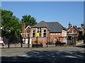
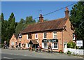
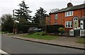
Photos of CM4 9HT


Area Information
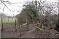
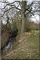
Margaretting is a historic village and civil parish located in the Chelmsford district of Essex. The civil parish of CM4 9HT sits approximately four miles southwest of Chelmsford, positioning it along the B1002 road near the River Wid. A specific postcode area covering a small residential cluster here reflects the settlement's status as a rural village astride a Roman road between London, Chelmsford, and Colchester. The population stands at 1,724 people, creating a low population density of 73 people per square kilometre. The settlement pattern is essentially medieval, historically featuring three manors and centred around the parish church. First mentioned in the Domesday Book of 1086, the area retains its traditional charm amidst rolling fields and woodlands. Residents value the serene environment which epitomises English rural life. Strict planning limits new builds to preserve the village envelope, ensuring the character remains unchanged. This location offers access to walking trails along the river while maintaining a distinct separation from the noise of surrounding motorways.
- Area Type
- Postcode
- Area Size
- Not available
- Population
- 1724
- Population Density
- 73 people/km²
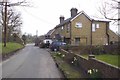
Living in CM4 9HT means entering a market dominated by houses. The accommodation type data confirms the overwhelming presence of detached or semi-detached properties suited to a rural estate. With 66 per cent of the population as home owners, the area functions primarily as an owner-occupied community rather than a rental market. This high level of ownership typically signals good long-term investment potential for buyers who can afford the local price points. The housing stock has evolved slowly over centuries, moving from medieval manor houses to the larger developments that arrived from the 1920s onwards. Because the postcode covers a small residential cluster within a village envelope, selection is naturally limited compared to urban centres. Potential buyers often graze the wider area, looking for homes in the immediate surroundings that maintain the established character. The lack of high-rise flats or student housing ensures the property values remain linked to family and retiree requirements. Market activity here depends heavily on the wider demand for the historic charm of the village.
House Prices in CM4 9HT
No properties found in this postcode.
Energy Efficiency in CM4 9HT
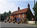
Residents of CM4 9HT enjoy a rural lifestyle supported by locally accessible amenities within practical reach. There are five notable retail options nearby, including Budgens Ingatestone, Chelmsford Star Co-operative Society Co, and Budgens Stock, offering essential shopping without needing to travel to the town centre. Four rail stations provide connectivity, with Ingatestone Railway Station, Billericay Railway Station, and Chelmsford Railway Station forming the backbone of public transport links. The village centre features the historic Red Lion pub, serving as a central social hub for the local community. The parish church of St Margaret and the conservation area including Margaretting Hall offer landmarks that define the visual character of the neighbourhood. Picturesque walking trails along the River Wid provide leisure opportunities for residents seeking outdoor activity. Strict planning constraints preserve the fragile nature of the village, preventing the development of large commercial complexes that would detract from the serene environment.
Amenities
Schools
Families considering homes in CM4 9HT have access to two primary schools within the vicinity. Margaretting Church of Education Voluntary Controlled Primary School serves as one of the nearest education providers for the local community. Stock Church of England Primary School offers an alternative option, and notably, it holds a good Ofsted rating. Both institutions are primary schools, which means the local educational infrastructure is focused on younger children rather than secondary education within the immediate cluster. This necessitates that older students typically travel further for high school education outside of the direct postcode area. The Ofsted rating of good for Stock Church of England Primary School provides reassurance regarding educational quality for younger pupils living in the area. Parents often weigh these specific options against the available housing that sits within the walking or school bus catchment zones of these institutions.
| Rank | School | Type | Entry gender | Ages |
|---|
Explore more schools in this area
Go to Schools tabDemographics
The community within CM4 9HT reflects an established population where women typically form the majority. The median age is 47, falling within the range of older generations, yet the most common age demographic consists of adults aged 30 to 64 years. This age profile indicates a mixture of active families and older retirees settled in the village. Home ownership is high, with 66 per cent of households owning their homes. This significant majority suggests the area attracts buyers seeking stability rather than tenants looking for flexibility. The predominant accommodation type consists of houses, fitting the rural landscape better than apartments or flats. The predominant ethnic group in this specific cluster is White, aligning with the typical demographic of historic Essex villages. There are no large employment centres directly within the postcode itself, meaning income levels are heavily influenced by the wider Chelmsford and London commuting zones. The housing stock remains relatively stable, with population growth being slow from 517 in 1851 to 1,724 residents recorded today.
Household Size
Accommodation Type
Tenure
Ethnic Group
Religion
Household Composition
Age
Household Deprivation
NS-SEC
Explore more demographic insights in this area
Go to Demographics tabPlanning
Planning Constraints
- Flood RiskPremium
- Ramsar Wetland SitesPremium
- Area of Outstanding Natural BeautyPremium
- Protected Nature ReservePremium
- Protected WoodlandPremium