Area Overview for CM4 9EW
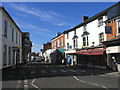
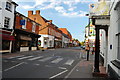
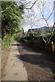
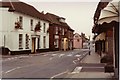
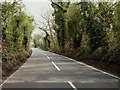
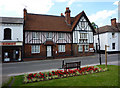
Photos of CM4 9EW
Area Information
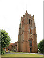
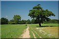
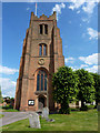
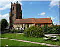
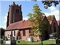
Living in CM4 9EW means residing within a specific postcode cluster that serves as a key part of the Ingatestone and Fryerning civil parish. This area forms part of a larger rural parish in the Brentwood Borough of Essex, covering an expanse of almost 4,000 acres surrounded by the Metropolitan Green Belt. The population stands at 1,717 residents, creating a low-density environment with 769 people per square kilometre. The location sits along the historic A12 route, an ancient Roman road that connects residents to the wider region while maintaining a distinct rural character. The area blends historical significance with modern commuter convenience. Ingatestone Hall, a Tudor house dating back to the 1540s, and St Edmund and St Mary Church, with Norman architecture over 900 years old, anchor the community's heritage. However, daily life also revolves around practical needs found in the villages. You will find ribbon development along historic routes and conservation areas that define the local landscape. The civil parish merged in 1889, combining the ancient settlements of Ingatestone and Fryerning, which were once prosperous coaching stops. Today, the area appeals to those seeking a rural setting with access to established transport links, offering a pace of life far removed from the congestion of the inner county.
- Area Type
- Postcode
- Area Size
- Not available
- Population
- 1717
- Population Density
- 769 people/km²
Homes in CM4 9EW are part of a market characterised by high home ownership, with 69% of the 1,717 residents owning their property. This figure places the area firmly in owner-occupied territory, making it an environment where stability drives transactions. The accommodation type is exclusively houses, which aligns with the rural parish setting and the suburban villages of Ingatestone and Fryerning. These homes are situated within a landscape that includes two villages and conservation areas, noting the presence of areas designated for heritage preservation like the Ingatestone High Street Conservation Area. The postcode cluster covers a small residential lobe within a much larger 4,000-acre parish. You are looking at properties that benefit from the green belt surroundings but are integrated into existing village structures. The market here is not about high-rise blocks or new-build estates; it is about existing stock within a historical framework. The high ownership rate suggests that investment properties or pure rentals are rarely the primary use case for landlords in this specific cluster. When viewing homes in this postcode, you will encounter properties that have been inhabited by the same families for generations. This lack of transient ownership means that many homes have undergone gradual modification over time, often respecting the architectural style of the Tudor halls and Norman churches nearby.
House Prices in CM4 9EW
No properties found in this postcode.
Energy Efficiency in CM4 9EW
Your lifestyle in CM4 9EW is centred around a range of practical amenities located within easy reach. Retail options include five notable venues, specifically Budgens Ingatestone, Chelmsford Star Co-operative Society Co, and M&S Brentwood Connect BP. These supermarkets and stores provide essential shopping needs without requiring a long drive to the city centre. The area is not a retail hub but rather a destination where daily necessities are conveniently located nearby. Transport connectivity is equally important for your leisure and daily routine. Five notable railway stations serve the area, including Ingatestone Railway Station, Billericay Railway Station, and Shenfield Railway Station. These transport nodes allow you to explore beyond the parish boundaries for dining, cinema, or extended shopping trips. The area is a conservation village, which means your leisure time is often spent exploring local landmarks such as Ingatestone Hall, St Edmund and St Mary Church, and Mill Green Windmill. The prominence of Fryerning Lane and High Street junction, marked by sarsen stones, also suggests a lifestyle that values heritage walks and quiet exploration of the local landscape. The character of the parish encourages a slower pace, where the 4,000 acres of surrounding green belt offers ample space for outdoor activity and a connection to the historic countryside.
Amenities
Schools
Families in CM4 9EW have access to the Anglo European School, which operates as both a primary and an academy establishment. The academy branch holds an Ofsted rating of good, indicating a standard of education that meets national expectations. This single school entity appears in the immediate vicinity of the postcode, suggesting a concentrated provision of education rather than a wide spread of options. The designation of the school as both primary and academy hints at a facility that may cater to a broad age range or serves a specific comprehensive model, though the data explicitly lists it under these two headers. When considering schools near the area, your choices are focused on this provision, which aligns with the rural nature of the parish. The presence of a good-rated academy reassures parents looking for educational quality within the Ingatestone and Fryerning civil parish. The school's location serves the wider community, providing an educational anchor for families residing in the housing clusters around the postcode. There are no other schools listed in the immediate vicinity data, meaning that the Anglo European School is the primary educational institution referenced for this specific postal location. Prospective parents should note that with a median age of 47, the primary demographic for local schooling comes from this adult age bracket. The school's status as a good-rated academy is the key metric for families evaluating their options in this neighbourhood.
| Rank | School | Type | Entry gender | Ages |
|---|
Explore more schools in this area
Go to Schools tabDemographics
The community in CM4 9EW is defined by a mature demographic with a median age of 47 years. The majority of the population falls into the adult age range of 30 to 64 years old, indicating a neighbourhood populated by established residents rather than young families or students. This age profile suggests a stable community where long-term settlement is common. Home ownership is the dominant form of tenure, with 69% of residents owning their homes outright or via a mortgage. Consequently, the annual 150-250 households are likely comprised of owner-occupiers who have invested in the local property market over decades. Accommodation type data confirms that houses are the primary dwelling style, aligning with the village setting and the surrounding 4,000 acres of the parish. The predominant ethnic group in this postcode is White, reflecting the demographic trends of many parts of East Essex. The high home ownership rate combined with the specific age range points towards a quiet, established neighbourhood where practicality often trumps trendiness. Residents are likely to be familiar with the local conservation areas and the history of Fryerning and Ingatestone, including the sarsen stones that mark the village origins. This demographic reality means that buying a home here requires patience, as the market is driven by local need rather than transient trends.
Household Size
Accommodation Type
Tenure
Ethnic Group
Religion
Household Composition
Age
Household Deprivation
NS-SEC
Explore more demographic insights in this area
Go to Demographics tabPlanning
Planning Constraints
- Flood RiskPremium
- Ramsar Wetland SitesPremium
- Area of Outstanding Natural BeautyPremium
- Protected Nature ReservePremium
- Protected WoodlandPremium