Area Overview for CM4 0HG
Photos of CM4 0HG


Area Information
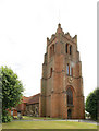
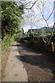
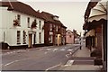
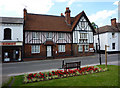
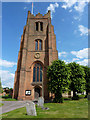
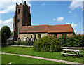
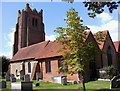
CM4 0HG is a small residential postcode in Essex, covering parts of Ingatestone and Fryerning, two villages with a rich historical legacy. The area has a population of 1717, with a high density of 769 people per square kilometre, reflecting its compact, clustered nature. Situated along the historic A12 route, it lies within the Metropolitan Green Belt, blending rural charm with commuter accessibility. Ingatestone and Fryerning were formed in 1889 from merged parishes, with Saxon origins marked by sarsen stones. Today, the area retains a distinct rural character, with ribbon development along historic roads and conservation areas preserving its heritage. Residents benefit from proximity to rail links and a mix of local amenities, while the surrounding countryside offers a tranquil backdrop. The postcode is ideal for those seeking a balance between small-town living and proximity to urban centres, with Ingatestone Hall and St Edmund and St Mary Church among its notable landmarks.
- Area Type
- Postcode
- Area Size
- Not available
- Population
- 1717
- Population Density
- 769 people/km²
The property market in CM4 0HG is characterised by a high rate of home ownership (69%) and a focus on houses rather than flats or apartments. This suggests a predominantly owner-occupied area, likely attracting families and professionals seeking stable, long-term housing. The small postcode area and its immediate surroundings may offer limited property diversity, with homes likely reflecting the semi-rural nature of the villages. Buyers should consider the compact size of the area, which may mean competition for properties and limited new developments. The high home ownership rate also implies a strong sense of community, with residents potentially invested in local amenities and conservation efforts. However, the lack of specific data on property prices or types means further research into individual listings would be necessary for a complete market analysis.
House Prices in CM4 0HG
No properties found in this postcode.
Energy Efficiency in CM4 0HG
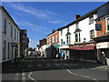
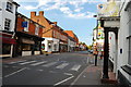
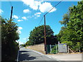
The lifestyle in CM4 0HG is shaped by its mix of local shops and transport links. Nearby retail options include Budgens Ingatestone, Chelmsford Star Co-operative Society, and other small stores, offering convenience for daily essentials. The area’s rail stations provide access to broader shopping and leisure opportunities in nearby towns. While the data does not list parks or recreational spaces explicitly, the surrounding countryside and conservation areas suggest opportunities for walking or outdoor activities. The villages’ historic character, including Ingatestone Hall and St Mary the Virgin Church, adds cultural value to daily life. The compact nature of the area means amenities are within easy reach, though residents may need to travel further for larger retail or entertainment options.
Amenities
Schools
The nearest schools to CM4 0HG include the Anglo European School, which operates as both a primary school and an academy with a good Ofsted rating. This dual provision offers families a range of educational options, from early years to secondary-level education. The academy’s good rating indicates a satisfactory standard of teaching and facilities, though specific details on curriculum or student outcomes are not provided. The presence of a single named school suggests a small-scale educational landscape, which may be advantageous for close-knit communities but could limit choices for larger families or those seeking specialist provision. Parents should verify whether the school’s capacity meets local demand, though the good rating provides reassurance about its overall performance.
| Rank | School | Type | Entry gender | Ages |
|---|
Explore more schools in this area
Go to Schools tabDemographics
The population of CM4 0HG has a median age of 47, with the majority of residents aged 30–64. This suggests a community skewed towards middle-aged adults, likely including professionals and families. Home ownership stands at 69%, indicating a stable, long-term resident base. The area is predominantly composed of houses rather than flats or apartments, reflecting a suburban or semi-rural housing stock. The predominant ethnic group is White, though specific data on diversity or deprivation is not provided. The age profile and ownership rates suggest a mature, settled community with limited turnover, which can contribute to a cohesive local environment. However, the lack of data on income levels or deprivation means the full picture of quality of life remains partially unexplored.
Household Size
Accommodation Type
Tenure
Ethnic Group
Religion
Household Composition
Age
Household Deprivation
NS-SEC
Explore more demographic insights in this area
Go to Demographics tabPlanning
Planning Constraints
- Flood RiskPremium
- Ramsar Wetland SitesPremium
- Area of Outstanding Natural BeautyPremium
- Protected Nature ReservePremium
- Protected WoodlandPremium