Area Overview for CM3 8EY
Photos of CM3 8EY


Area Information
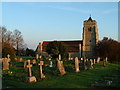
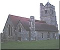
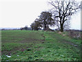
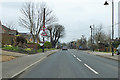
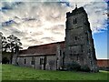
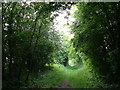
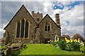
Living in CM3 8EY means being part of a small, residential cluster in Rettendon, a village with historical roots dating back to the Doomsday Book. The area’s population of 1,651 residents is spread across a compact footprint, with a density of 356 people per square kilometre. This is a place where the past meets the present: medieval architecture like All Saints’ Church stands alongside modern amenities such as Co-op stores and railway stations. The village’s layout, with Rettendon Common and Rettendon Place separated by 1.5 miles, offers a mix of rural charm and accessible services. Daily life here is shaped by proximity to nature, with the River Crouch forming a boundary, and a community profile skewed toward adults aged 30–64. The area is well-connected to nearby towns like Chelmsford, with rail links to Battlesbridge, South Woodham Ferrers, and Wickford. For those seeking a balance between tradition and convenience, CM3 8EY provides a quiet yet practical base.
- Area Type
- Postcode
- Area Size
- Not available
- Population
- 1651
- Population Density
- 356 people/km²
The property market in CM3 8EY is characterised by a high rate of home ownership (71%), with houses being the predominant accommodation type. This suggests a community where long-term residency is common, and the housing stock is likely to be established rather than newly built. The small area’s limited size means the market is not expansive, but the presence of multiple railway stations—Battlesbridge, South Woodham Ferrers, and Wickford—offers connectivity to larger towns. For buyers, this implies a focus on quality over quantity: properties here are likely to be family homes with limited new developments. The lack of rental data suggests the market is not heavily influenced by short-term lettings, making it a potentially secure investment for those seeking a place to settle. However, the compact nature of the area means competition for available homes may be fierce.
House Prices in CM3 8EY
No properties found in this postcode.
Energy Efficiency in CM3 8EY
The lifestyle in CM3 8EY is shaped by its proximity to retail, dining, and leisure options. Nearby, the Co-op Wickford, M&S South Woodham Ferrers BP, and Tesco Wickford provide essential shopping, while the village itself hosts Rettendon Primary School and the Rettendon Memorial Hall. The area’s rural setting is complemented by its accessibility to the River Crouch and nearby green spaces, offering opportunities for walking or cycling. The presence of multiple railway stations means residents can easily reach larger towns for more extensive amenities. The modest scale of the area ensures a community feel, with local venues like the memorial hall serving as social hubs. While the retail options are limited to nearby towns, the combination of rail links and digital connectivity ensures convenience for everyday needs.
Amenities
Schools
Residents of CM3 8EY have access to two primary schools: Rettendon Primary School, which holds a ‘good’ Ofsted rating, and St Luke’s Park Primary School. Both institutions serve the local community, ensuring children have nearby options for early education. The presence of two primary schools within practical reach supports families with young children, reducing the need for long commutes. While no secondary schools are listed, the proximity to larger towns like Chelmsford—reachable via rail—means students can access broader educational facilities. The quality of Rettendon Primary School, in particular, adds value to the area, as a strong foundation in early education can influence long-term academic outcomes. For parents, the availability of two primary schools provides flexibility and competition in educational standards.
| Rank | School | Type | Entry gender | Ages |
|---|
Explore more schools in this area
Go to Schools tabDemographics
CM3 8EY’s population skews toward middle-aged adults, with a median age of 47 and the majority (71%) of residents owning their homes. This suggests a stable, long-term community rather than a transient rental market. The area is predominantly occupied by houses, reflecting a focus on family-friendly living. The predominant ethnic group is White, and the population density—356 people per square kilometre—indicates a modest, closely-knit settlement. The age profile, centred on those aged 30–64, implies a demographic with established careers and families. While the data does not specify deprivation levels, the high home ownership rate and mature age range may correlate with lower turnover and a sense of permanence. This profile aligns with a community prioritising stability over rapid change, with services tailored to older and middle-aged residents.
Household Size
Accommodation Type
Tenure
Ethnic Group
Religion
Household Composition
Age
Household Deprivation
NS-SEC
Explore more demographic insights in this area
Go to Demographics tabPlanning
Planning Constraints
- Flood RiskPremium
- Ramsar Wetland SitesPremium
- Area of Outstanding Natural BeautyPremium
- Protected Nature ReservePremium
- Protected WoodlandPremium