Area Overview for CM3 1BF
Photos of CM3 1BF

Area Information
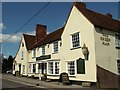
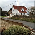
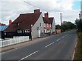
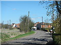
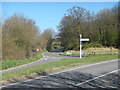
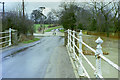
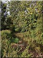
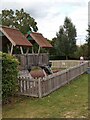
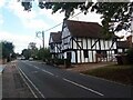
Living in CM3 1BF means being part of a small, tightly knit residential cluster in the heart of Great Waltham, a rural parish in Essex. The area’s population of 1,373 people is spread across 73 individuals per square kilometre, creating a quiet, village-like atmosphere. Nestled along the River Chelmer, the postcode falls within a civil parish that includes two villages and seven hamlets, offering a blend of historic charm and natural scenery. The area’s character is shaped by its medieval roots, with landmarks like the 16th-century Badynghams building and the parish church, which dates back to the Anglo-Saxon era. Daily life here is defined by a slower pace, with residents benefiting from proximity to nearby towns like Chelmsford, accessible via multiple railway stations. The mix of historic buildings, countryside walks, and local amenities makes CM3 1BF appealing to those seeking a balance between rural tranquillity and practical connectivity.
- Area Type
- Postcode
- Area Size
- Not available
- Population
- 1373
- Population Density
- 73 people/km²
The property market in CM3 1BF is primarily owner-occupied, with 70% of homes owned by residents rather than rented. The accommodation type is predominantly houses, which is typical of rural and semi-rural areas. This suggests a market skewed towards family homes and larger properties, rather than apartments or flats. Given the small size of the postcode area, the housing stock is limited, making it a niche market for buyers seeking specific properties. The focus on houses may appeal to those prioritising space and land, though the lack of flats could limit options for those preferring urban living. Buyers should consider the proximity to nearby towns like Chelmsford for additional amenities, as the immediate area offers limited commercial or retail development.
House Prices in CM3 1BF
No properties found in this postcode.
Energy Efficiency in CM3 1BF
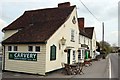
The lifestyle in CM3 1BF is shaped by its rural setting and proximity to nearby amenities. Within practical reach are five retail venues, including major supermarkets like Morrisons Chelmsford, providing convenience for shopping. The area’s character is enhanced by historic buildings, such as the 16th-century Badynghams, and the River Chelmer, which offers scenic walks. The nearby railway stations connect residents to Chelmsford and beyond, enabling access to larger towns for dining, leisure, and cultural activities. The mix of retail options and transport links supports a practical lifestyle, while the village atmosphere maintains a sense of community. The area’s blend of heritage and accessibility makes it appealing for those seeking a balanced rural-urban existence.
Amenities
Schools
The nearest school to CM3 1BF is Ford End Church of England Primary School, which serves the local community with a primary education offering. The school holds an Ofsted rating of ‘good’, indicating a satisfactory standard of teaching and facilities. As a primary school, it caters to younger children, though no secondary schools are listed in the data. The presence of a single primary school suggests that families may need to travel to nearby towns for secondary education. The ‘good’ rating reflects a reliable educational foundation, but parents should consider the availability of further schooling options when planning for long-term family needs.
| Rank | School | Type | Entry gender | Ages |
|---|
Explore more schools in this area
Go to Schools tabDemographics
The community in CM3 1BF is predominantly middle-aged, with a median age of 47 and the majority of residents falling within the 30-64 age range. Home ownership is high at 70%, reflecting a stable, long-term population. The area is characterised by a predominance of houses over flats, aligning with its rural and semi-rural setting. The predominant ethnic group is White, with no specific data provided on other demographics. The low population density of 73 people per square kilometre suggests a spread-out, less congested environment. This demographic profile indicates a community focused on family living and long-term residency, with fewer transient residents. The age range also suggests a mix of working-age adults and retirees, contributing to a balanced local economy.
Household Size
Accommodation Type
Tenure
Ethnic Group
Religion
Household Composition
Age
Household Deprivation
NS-SEC
Explore more demographic insights in this area
Go to Demographics tabPlanning
Planning Constraints
- Flood RiskPremium
- Ramsar Wetland SitesPremium
- Area of Outstanding Natural BeautyPremium
- Protected Nature ReservePremium
- Protected WoodlandPremium