Area Overview for CM22 7BE
Photos of CM22 7BE
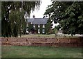
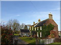

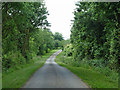
4 photos from this area
Area Information
Key information about the CM22 7BE including its size, population, and administrative classification.
- Area Type
- Postcode
- Area Size
- 12.3 hectares
- Population
- 2002
- Population Density
- 184 people/km²
House Prices in CM22 7BE
13
Properties
£755,625
Average Sold Price
£370,000
Lowest Price
£1,125,000
Highest Price
Showing 13 properties
| Address | Type | Beds | Baths | Last Sale Price | Last Sale Date | |
|---|---|---|---|---|---|---|
| Rookwood, Friars Lane, Hatfield Heath, CM22 7BE | house | - | - | £745,000 | Oct 2020 | |
| Heathfields, Friars Lane, Hatfield Heath, CM22 7BE | Detached | 5 | - | £1,125,000 | May 2019 | |
| Oakhanger, Friars Lane, Hatfield Heath, CM22 7BE | Detached | 2 | - | £815,000 | Jun 2018 | |
| Dornywood House, Friars Lane, Hatfield Heath, CM22 7BE | Detached | 4 | - | £1,040,000 | Feb 2017 | |
| Friarswood, Friars Lane, Hatfield Heath, CM22 7BE | Detached | 5 | - | £1,042,500 | Mar 2016 | |
| Bramfield, Friars Lane, Hatfield Heath, CM22 7BE | house | - | - | £500,000 | Jan 2013 | |
| Squirrels, Friars Lane, Hatfield Heath, CM22 7BE | Detached | - | - | £407,500 | Feb 2003 | |
| Apple Trees, Friars Lane, Hatfield Heath, CM22 7BE | Detached | - | - | £370,000 | Jun 2002 | |
| Formerly Known As Heritage Cottage, Friars Lane, Hatfield Heath, CM22 7BE | Detached | - | - | - | - | |
| Ashyln, Friars Lane, Hatfield Heath, CM22 7BE | undefined | - | - | - | - |
Page 1 of 2
Energy Efficiency in CM22 7BE
Amenities
Schools
| Rank | School | Type | Entry gender | Ages |
|---|
Explore more schools in this area
Go to Schools tabDemographics
Household Size
Family (3-5 people)
most common
Accommodation Type
Houses
most common
Tenure
72
majority
Ethnic Group
White
most common
Religion
N/A
most common
Household Composition
N/A
most common
Age
47
median
Adults (30-64 years)
most common
Household Deprivation
N/A
with no deprivation
NS-SEC
40
in Lower managerial occupations
Explore more demographic insights in this area
Go to Demographics tabPlanning
Planning Constraints
- Flood RiskPremium
- Ramsar Wetland SitesPremium
- Area of Outstanding Natural BeautyPremium
- Protected Nature ReservePremium
- Protected WoodlandPremium