Area Overview for CM2 0PG
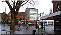
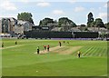
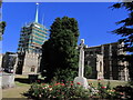
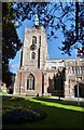
Photos of CM2 0PG


Area Information
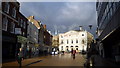
Living in CM2 0PG means inhabiting a compact, high-density residential cluster in the heart of Chelmsford, Essex. This postcode area, covering 9,850 m², is part of the Moulsham and Central Ward, a historically significant urban space with roots dating to the Neolithic period. The area blends residential, commercial, and cultural uses, centred around Moulsham Street, the city’s oldest thoroughfare. With a population of 1,243, it is densely populated, reflecting the urban character of Chelmsford’s city centre. The area’s proximity to retail hubs, railway stations, and historic landmarks like the 1787 stone bridge and St John’s Church (1837) makes it a dynamic place for those seeking convenience and connectivity. However, its small size and high population density mean it is a tightly knit, fast-paced environment, ideal for commuters and those prioritising access to city amenities over expansive living spaces. The ward supports over 30% of Chelmsford’s jobs, driven by retail, finance, and professional services, creating a lively economic backdrop for residents.
- Area Type
- Postcode
- Area Size
- 9850 m²
- Population
- Not available
- Population Density
- Not available
The property market in CM2 0PG is characterised by a high proportion of rental properties, with only 22% of homes owned by residents. This reflects the area’s role as a secondary housing market, likely catering to commuters and professionals working in Chelmsford’s city centre. The accommodation type is predominantly flats, which suits the high population density and compact footprint of the area. Given its small size and limited housing stock, buyers seeking owner-occupied properties may find the market challenging, with limited scope for long-term investment. The prevalence of flats also means that the area is more suited to those prioritising proximity to amenities over spacious living conditions. Surrounding areas may offer more varied options, but CM2 0PG itself remains a niche, high-density zone with limited property diversity.
House Prices in CM2 0PG
Showing 2 properties
| Address | Type | Beds | Baths | Last Sale Price | Last Sale Date | |
|---|---|---|---|---|---|---|
| Anglia Physiotherapy, Essex County Ground, New Writtle Street, Chelmsford, CM2 0PG | commercial | - | - | - | - | |
| The Groundsmans House, Essex County Ground, New Writtle Street, Chelmsford, CM2 0PG | Detached | - | - | - | - |
Energy Efficiency in CM2 0PG
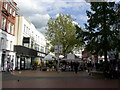
Living in CM2 0PG offers access to a range of amenities within practical reach, including five retail outlets such as Morrisons Daily, Tesco Chelmsford, and M&S Chelmsford. These shops cater to everyday needs, while the proximity to Chelmsford’s commercial and retail heart ensures a vibrant urban lifestyle. The area’s historic character, including Moulsham Street’s medieval buildings and the 1787 stone bridge, adds cultural depth to daily life. Rail links to Chelmsford and Ingatestone provide easy access to broader networks, and the ward’s role as a hub for retail and professional services supports a dynamic economy. While green spaces are not explicitly mentioned, the area’s focus on commercial and residential density suggests a lifestyle centred on convenience, connectivity, and urban amenities.
Amenities
Schools
| Rank | School | Type | Entry gender | Ages |
|---|
Explore more schools in this area
Go to Schools tabDemographics
The community in CM2 0PG is predominantly middle-aged, with the most common age range being 30–64 years, despite a median age of 22. This suggests a mix of younger and older residents, possibly due to transient populations or family structures. Home ownership is low at 22%, indicating that the majority of residents are likely renting, which may reflect the area’s role as a rental-focused zone within a larger urban economy. The accommodation type is primarily flats, aligning with the high population density of 126,189 people per km². The predominant ethnic group is White, though specific data on diversity or deprivation is not provided. The low home ownership rate and high density suggest a community shaped by rental markets and shared living spaces, with potential implications for long-term stability and investment.
Household Size
Accommodation Type
Tenure
Ethnic Group
Religion
Household Composition
Age
Household Deprivation
NS-SEC
Explore more demographic insights in this area
Go to Demographics tabPlanning
Planning Constraints
- Flood RiskPremium
- Ramsar Wetland SitesPremium
- Area of Outstanding Natural BeautyPremium
- Protected Nature ReservePremium
- Protected WoodlandPremium