Area Overview for CM2 0PE
Photos of CM2 0PE


Area Information
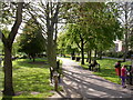
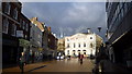
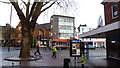
CM2 0PE represents a specific residential cluster within the broader urban fabric of Chelmsford, Essex. This postcode covers exactly 228 square metres, indicating a highly compact living space typical of city centre developments. The area contains a population of 1,243 residents, creating a tight-knit environment where daily interactions are frequent. Located in the Moulsham and Central Ward, you are positioned centrally relative to the historic core of the city. This ward encompasses the suburb of Moulsham and extends south from Chelmsford city centre, placing you near Old Moulsham along Moulsham Street, the city's oldest street. Living in CM2 0PE means residing in a zone defined by a dense mix of residential, commercial, and educational uses. The surrounding landscape supports over 30% of the city's jobs, embedding your home within a dynamic economic engine. Daily life here blends the convenience of urban living with proximity to significant local landmarks such as St John's Church, built in 1837. The area retains historical depth, dating back to Roman-era settlement and featuring sites like Marconi's first radio factory on Hall Street. You benefit from being part of a functional city hub where commercial and retailing activities thrive alongside newer residential projects on Victoria Road and the former Anglia Ruskin site.
- Area Type
- Postcode
- Area Size
- 228 m²
- Population
- Not available
- Population Density
- Not available
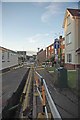
The housing landscape in CM2 0PE is defined by a heavy reliance on rental accommodation and a scarcity of owner-occupied properties. Data indicates that only 22% of locals own their homes, suggesting that the majority of this 228 square metre cluster operates as a rental market. Flats dominate the accommodation type available, aligning with the postcodes nature as a small residential cluster in the city centre. This structure presents a specific opportunity for buyers seeking investment properties or tenants looking for long-term leases within a high-demand zone. Because home ownership is low, the market may be more fluid compared to areas with established owner-occupier communities. You should expect properties to be compact and optimised for urban living, consistent with the flat prevalence in this area. The immediate surroundings in Chelmsford's Moulsham and Central Ward share similar housing characteristics, with new residential developments replacing older industrial sites. This shift in planning has altered the visual character of the area, introducing modern buildings near the historic core. For those considering homes in CM2 0PE, understanding the high rental proportion helps contextualise purchase prices and potential rental yields in this unique urban pocket.
House Prices in CM2 0PE
Showing 2 properties
| Address | Type | Beds | Baths | Last Sale Price | Last Sale Date | |
|---|---|---|---|---|---|---|
| Offices, 70-72 New London Road, Chelmsford, CM2 0PE | Office | - | - | - | - | |
| 70-72 New London Road, Chelmsford, CM2 0PE | retail_financial | - | - | - | - |
Energy Efficiency in CM2 0PE
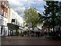
Living in CM2 0PE places you minutes away from five key retail destinations and three major railway hubs. You can shop at M&S Chelmsford, Morrisons Daily, and Tesco Chelmsford, all situated within practical reach of the postcode. This proximity to a Morrisons and Tesco means everyday groceries are accessible without a car. The area is strategically positioned near the G1 Frankland Bridge, which links Moulsham Street to the High Street, facilitating easy walking access to the city centre. Cultural offerings are abundant nearby, including the British Library Society of Natural History and the Chelmsford Museum of Archaeology. You are also close to the Chelmsford Open Market, which operates on Wednesdays and Saturdays. Sports enthusiasts can visit Riverside Stadium or the Chelmsford Civic Centre. The conservation area status of the surrounding ward, established in the latest town centre plan, ensures that historic architecture remains preserved. You benefit from being embedded in a zone that balances retail convenience with cultural heritage, offering a walkable lifestyle where major supermarkets and transport nodes are essentially on your doorstep.
Amenities
Schools
| Rank | School | Type | Entry gender | Ages |
|---|
Explore more schools in this area
Go to Schools tabDemographics
The community residing in CM2 0PE displays a distinct age profile centred on younger adults. Your neighbours typically fall within the 30 to 64 years range, which constitutes the most common age bracket for the demographic. The median age for the population is recorded at 22 years, reinforcing the youthful character of the locality. You are living in an area where only 22% of residents own their homes, suggesting a rental-dominant market or a high volume of first-time buyers. The predominant accommodation type here consists of flats, reflecting the urban density of the postcode area. Diversity in this cluster is significant, with White residents forming the predominant ethnic group, though the low home ownership rate implies frequent turnover and a transient population. This demographic composition affects the local vibrancy, with a high concentration of young professionals and families in the working age bracket. The high population density associated with this small area size contributes to a lively atmosphere where community engagement is immediate and shared spaces see high footfall. Understanding these figures provides a clear picture of who your fellow residents are, allowing you to gauge the social environment accurately against your personal needs.
Household Size
Accommodation Type
Tenure
Ethnic Group
Religion
Household Composition
Age
Household Deprivation
NS-SEC
Explore more demographic insights in this area
Go to Demographics tabPlanning
Planning Constraints
- Flood RiskPremium
- Ramsar Wetland SitesPremium
- Area of Outstanding Natural BeautyPremium
- Protected Nature ReservePremium
- Protected WoodlandPremium