Area Overview for CM18 6PR
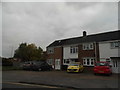
Photos of CM18 6PR


Area Information
Living in CM18 6PR means being part of a small, residential cluster in Harlow, Essex, where the population of 1,676 residents creates a tight-knit community feel. This postcode area, part of the Bush Fair ward, is defined by its housing stock, primarily developed around 2000, with pitched roofs and a focus on family homes. The area’s proximity to Harlow’s town centre and key transport links makes it accessible yet quiet, blending suburban comfort with practical connectivity. With a median age of 47, the community is dominated by adults aged 30–64, many of whom are homeowners. The presence of two schools, including a good-rated academy, and nearby retail outlets like Co-op Tye and Morrisons Daily, ensures daily needs are met. CM18 6PR’s low crime risk and absence of environmental constraints such as protected woodlands or AONB designations make it a stable, family-friendly location. Its rail and metro links, including Harlow Town and Epping stations, provide easy access to London and surrounding areas, while North Weald Airport adds to its strategic appeal. This area is ideal for those seeking a balanced lifestyle with access to amenities without the bustle of a larger town.
- Area Type
- Postcode
- Area Size
- Not available
- Population
- 1676
- Population Density
- 6245 people/km²
The property market in CM18 6PR is characterised by a 56% home ownership rate, with houses forming the majority of the accommodation stock. This suggests a community where many residents are long-term homeowners, though the small population size means the housing stock is limited. The focus on houses rather than flats or apartments indicates a preference for family-friendly, spacious living. For buyers, this means a market that prioritises stability and permanence over short-term rental opportunities. The area’s proximity to Harlow’s town centre and transport links may influence property values, but the lack of major planning constraints or environmental designations ensures a straightforward purchasing process. Given the small size of CM18 6PR, buyers should consider the immediate surroundings for a broader range of options. The housing stock, developed around 2000, likely includes modern, well-maintained properties, though specific details on condition or age are not provided.
House Prices in CM18 6PR
No properties found in this postcode.
Energy Efficiency in CM18 6PR
The lifestyle in CM18 6PR is shaped by its proximity to essential amenities and community-focused infrastructure. Retail options include Co-op Tye and Morrisons Daily, providing grocery and convenience shopping within walking distance. Rail and metro stations such as Harlow Town and Epping offer easy access to Harlow’s town centre and beyond, while North Weald Airport adds to the area’s connectivity. Though the data does not mention parks or leisure facilities, the absence of planning constraints like AONB or protected woodlands suggests open spaces may be available nearby. The area’s character is defined by practicality, with amenities designed to meet daily needs without the need for long commutes. This balance of accessibility and quiet living makes CM18 6PR suitable for families and professionals seeking convenience without sacrificing comfort.
Amenities
Schools
Residents of CM18 6PR have access to two primary schools: William Martin Church of England Voluntary Controlled Junior School in Harlow, which is a traditional state school, and William Martin Church of England Junior School, an academy with a good Ofsted rating. Both institutions cater to younger children, providing a range of educational options for families. The presence of an academy with a good rating suggests a commitment to quality education, though the absence of secondary schools means parents may need to look beyond the immediate area for comprehensive schooling. The dual school options allow families to choose between a faith-based state school or a potentially higher-performing academy. This mix supports diverse educational preferences but underscores the need for planning when considering long-term family needs.
| Rank | School | Type | Entry gender | Ages |
|---|
Explore more schools in this area
Go to Schools tabDemographics
CM18 6PR’s population of 1,676 is predominantly composed of adults aged 30–64, with a median age of 47. This suggests a mature, established community with a strong focus on family living. Home ownership rates stand at 56%, indicating a mix of owner-occupied properties and rentals. The area’s accommodation type is primarily houses, reflecting a preference for single-family homes over flats or apartments. The predominant ethnic group is White, which aligns with broader trends in the region. The absence of specific deprivation data means the quality of life can be inferred from the area’s safety and amenities. With a low crime risk score of 68 and no environmental constraints, residents benefit from a stable, low-stress environment. The demographic profile suggests a community that values security, convenience, and proximity to essential services, making it appealing to professionals and families alike.
Household Size
Accommodation Type
Tenure
Ethnic Group
Religion
Household Composition
Age
Household Deprivation
NS-SEC
Explore more demographic insights in this area
Go to Demographics tabPlanning
Planning Constraints
- Flood RiskPremium
- Ramsar Wetland SitesPremium
- Area of Outstanding Natural BeautyPremium
- Protected Nature ReservePremium
- Protected WoodlandPremium