Area Overview for CM18 6EH
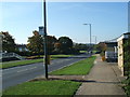
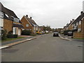
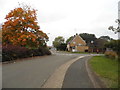
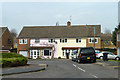
Photos of CM18 6EH


Area Information
Living in CM18 6EH means being part of a small, defined residential cluster in Harlow, Essex. The area, part of the Bush Fair ward, is a housing estate developed around 2000, primarily by South Anglia Housing Association. With a population of 1,433, it is a tight-knit community where homes are predominantly houses with pitched roofs. The postcode sits within the Harlow district, a unitary authority in Eastern England, and is geographically positioned at 51.762714, 0.099702. Daily life here is shaped by its proximity to nearby towns and amenities, though the area itself remains focused on residential living. Residents benefit from straightforward access to transport links, including rail and metro stations, which connect to broader regional networks. The character of CM18 6EH is defined by its modest scale, with limited commercial activity but sufficient infrastructure to support local needs. For those seeking a quiet, low-density environment with practical connectivity, this area offers a balance of residential comfort and functional accessibility.
- Area Type
- Postcode
- Area Size
- Not available
- Population
- 1433
- Population Density
- 3719 people/km²
The property market in CM18 6EH is characterised by a 42% home ownership rate, with the majority of properties being houses. This mix of owner-occupied and rental homes suggests a community where long-term residency is common but not universal. The presence of houses, rather than flats or apartments, indicates a preference for single-family living, which may appeal to families or those seeking space. However, the low home ownership percentage implies that a significant portion of the housing stock is available for rent, potentially influencing the local property dynamics. Buyers should consider that the area’s small size means the immediate surroundings may hold more options. The housing association’s involvement in development also suggests a focus on affordability, though specific price ranges or investment potential are not detailed in the data.
House Prices in CM18 6EH
Showing 1 properties
| Address | Type | Beds | Baths | Last Sale Price | Last Sale Date | |
|---|---|---|---|---|---|---|
| Essex County Council, Educational Psychology Service, Brays House, Tracyes Road, Harlow, CM18 6EH | Office | - | - | - | - |
Energy Efficiency in CM18 6EH
The lifestyle in CM18 6EH is supported by a range of nearby amenities, including retail options such as Co-op Manor and Morrisons Daily, which cater to everyday shopping needs. The area’s proximity to rail and metro stations enhances its connectivity, making it easier to access urban centres for dining, entertainment, or leisure. While specific parks or recreational spaces are not detailed in the data, the presence of multiple transport links suggests access to broader green spaces in nearby towns. The practical reach of amenities like supermarkets and transport hubs contributes to a convenient, low-maintenance lifestyle. Residents can rely on these facilities for routine tasks, though the area’s small size means most social or cultural activities may require venturing slightly beyond CM18 6EH.
Amenities
Schools
Residents of CM18 6EH have access to several schools, including Holy Cross Catholic Primary School in Harlow, The Brays Grove Community School, and Purford Green Primary School, all of which hold an Ofsted rating of ‘good’. Passmores Academy, an academy school, also serves the area with a ‘good’ rating. The mix of primary schools and an academy provides families with a range of educational options, from faith-based institutions to state-funded academies. The consistent ‘good’ ratings suggest a reliable standard of education, though no secondary schools are listed in the data. This cluster of schools is likely to meet the needs of local children, with primary education being the primary focus. Parents seeking a variety of school types may find the proximity of these institutions convenient, though further research would be needed to assess their specific curricula or performance metrics.
| Rank | School | Type | Entry gender | Ages |
|---|
Explore more schools in this area
Go to Schools tabDemographics
The community in CM18 6EH is predominantly composed of adults aged 30–64, with a median age of 47. This suggests a population skewed toward middle-aged individuals, likely including families and professionals. Home ownership stands at 42%, indicating that nearly half of residents rent their homes, which may reflect the area’s role as a rental-focused estate. The accommodation type is primarily houses, which aligns with the housing association’s development model. The predominant ethnic group is White, with no specific data on other demographics provided. The age profile and ownership figures suggest a stable, established community with limited generational turnover. The absence of detailed diversity statistics means the area’s social composition remains largely unexplored in the data, though the focus on houses and moderate age range implies a practical, family-oriented environment.
Household Size
Accommodation Type
Tenure
Ethnic Group
Religion
Household Composition
Age
Household Deprivation
NS-SEC
Explore more demographic insights in this area
Go to Demographics tabPlanning
Planning Constraints
- Flood RiskPremium
- Ramsar Wetland SitesPremium
- Area of Outstanding Natural BeautyPremium
- Protected Nature ReservePremium
- Protected WoodlandPremium