Area Overview for CM17 9YP
Photos of CM17 9YP


Area Information
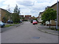
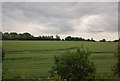
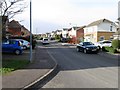
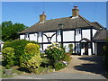
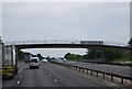
The postcode CM17 9YP sits within the Church Langley North and Newhall district, a council ward in Harlow, Essex. This specific residential cluster covers a small area with a resident population of 1,763. The wider ward encompasses 165 hectares, representing 5.40% of Harlow's total land area. Modern housing developments built from 1992 blend with historical features, creating a distinct suburban character. Ancient footpaths gave the area its name, and nearby Langley village retains a rural atmosphere with open greens and farmland surroundings. Residents live in a district that combines the convenience of a new estate with access to historic landmarks. The area lies adjacent to the M11 motorway and the A414. While the modern estate includes private ownership models, the surroundings reflect post-WW2 population growth and a peaceful upland landscape. You find community facilities integrated into the local design, alongside historic structures like Langley Hall farmhouse, an early 17th-century property with barns and a pond. Living in CM17 9YP means enjoying a setting that balances modern living with historical context. The coordinates 51.770661 and 0.130364 mark the postcode CM17 9LP within the broader development, illustrating the precise location of this residential zone. You are close to a 1993–1994 concrete water tower, visible from the M11 and serving as a landmark for locals. The environment offers a mix of suburban development and rural proximity, suitable for those seeking a quieter life near Harlow.
- Area Type
- Postcode
- Area Size
- Not available
- Population
- 1763
- Population Density
- 5993 people/km²
The property market in CM17 9YP is characterised by a strong preference for traditional housing forms. Houses represent the primary accommodation type in this postcode area. An impressive 83% of residents own their homes outright or with a mortgage. This statistic indicates that the market is overwhelmingly owner-occupied rather than a rental sector. You will rarely encounter private landlords operating high volumes of short-term lets or furnished flats in this cluster. The 1,763 population resides in a small residential cluster designed for permanent settlement. This density supports community growth without the volatility often seen in student housing corridors. The distinction between freehold and leasehold is not detailed, but the high ownership percentage suggests substantial capital investment by individuals in their local properties. This profile influences the types of buyers you might meet in this area. Most purchasers have remained for significant periods, fostering a sense of continuity. The layout of the estate, planned from 1992, means you are looking at established housing rather than a new-build boom. Property values here are driven by local demand within Harlow District Council rather than speculative investment. When buying homes in CM17 9YP, you compete for places that offer long-term utility and security. The lack of rental stock means families can secure accommodation without worrying about lease expiry or landlord permission. You are buying a home in a zone where residents have skin in the game. This stability often translates to better maintenance of the estate's common areas and facilities. The market operates on trust and locality, not just investment returns.
House Prices in CM17 9YP
No properties found in this postcode.
Energy Efficiency in CM17 9YP
Residents of CM17 9YP enjoy convenient access to essential amenities within practical reach. Five retail outlets serve daily needs, including Tesco Harlow, Co-op Newhall, and Morrisons Daily. These shops provide groceries, household essentials, and quick shopping trips without the need to travel far. The presence of these major chains ensures you can manage your weekly shop locally. Your leisure and dining options include the Potters Arms pub, a local venue for evening socialising. The ecumenical Church Langley Church offers a place for community events and spiritual gatherings. Families benefit from children's facilities, including a children's centre and nursery. Primary schools such as Church Langley Community Primary and Henry Moore Primary are located nearby, reducing commute times for end-of-school collections. Healthcare services are integrated into the estate, with a doctor and dentist located close to your doorstep. A petrol station and pharmacy are also available for emergency supplies or travel refuelling. This concentration of services creates a self-sufficient bubble where you can handle most tasks without leaving the local zone. The community hall acts as a hub for residents to interact and organise local activities. You live in an area that supports a balanced routine. After a day of work, you can walk to a shop or catch a bus nearby. Nearby Langley village adds to your lifestyle with its historic Grade II listed St John the Evangelist church. The 12th-century structure provides a quiet backdrop to modern suburban life. Your daily life is enhanced by the ability to reach the motorway for longer journeys or the local rail for shorter commutes.
Amenities
Schools
| Rank | School | Type | Entry gender | Ages |
|---|
Explore more schools in this area
Go to Schools tabDemographics
The community in CM17 9YP reflects a mature population with a median age of 47 years. Adults aged between 30 and 64 years form the most common age group in this cluster. With a home ownership rate of 83%, the neighbourhood is dominated by owner-occupiers rather than renters. This stability is evident in the accommodation type, which consists largely of houses rather than flats or apartments. The predominant ethnic group is White, consistent with the wider demographic profile of the region. You can expect a settled community where families and long-term residents shape the local culture. The high level of home ownership suggests residents have a permanent stake in the area, influencing everything from local engagement to property values. There is a clear focus on family stability, as the median age indicates fewer young households moving in frequently compared to student-rich university towns. These figures define the daily rhythm of life in CM17 9YP. The resident population of 1,763 creates a tight-knit feel within this small residential cluster. You are not in a diverse, multi-ethnic urban centre but in a planned development where residents share similar life stages. The data shows a lack of rental dependency, meaning noise from transient populations is unlikely to be an issue. The area functions as a bedroom community for those who value stability over the fast pace of city living.
Household Size
Accommodation Type
Tenure
Ethnic Group
Religion
Household Composition
Age
Household Deprivation
NS-SEC
Explore more demographic insights in this area
Go to Demographics tabPlanning
Planning Constraints
- Flood RiskPremium
- Ramsar Wetland SitesPremium
- Area of Outstanding Natural BeautyPremium
- Protected Nature ReservePremium
- Protected WoodlandPremium