Area Overview for CM17 9WT
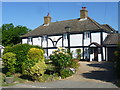
Photos of CM17 9WT


Area Information
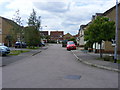
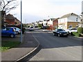
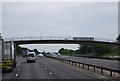
CM17 9WT is a small residential postcode in Harlow, Essex, blending modern housing developments with historic village character. The area, part of the Church Langley and Potter Street wards, sits between the A414 and M11 motorways, offering easy access to nearby towns and cities. With a population of 2,342, it is a compact community where suburban living meets traditional charm. Church Langley, developed between 1992 and 2005 on former farmland, features privately owned homes marketed as a village with community facilities. Potter Street, a medieval hamlet, retains its older village feel with narrow streets, shops, and a post office predating Harlow’s New Town era. Residents benefit from proximity to Harlow’s amenities, including retail, schools, and transport links. The area’s mix of modern infrastructure and historic roots creates a distinctive living environment, appealing to those seeking stability in a well-connected yet characterful setting.
- Area Type
- Postcode
- Area Size
- Not available
- Population
- 2342
- Population Density
- 8279 people/km²
The property market in CM17 9WT is characterised by high home ownership (82%) and a predominance of houses, indicating a suburban, family-oriented area. The housing stock reflects Church Langley’s development as a New Town expansion, with homes built on former farmland between 1992 and 2005. These properties are largely owner-occupied, suggesting a stable market with limited rental activity. The presence of community facilities, schools, and retail amenities in the area supports a lifestyle prioritising convenience and family needs. For buyers, the limited size of the postcode means the immediate surroundings are key—proximity to Harlow’s town centre and transport links adds value. However, the small population and focused housing stock mean the market is niche, appealing to those seeking a quiet, well-connected suburban location with a mix of modern and historic elements.
House Prices in CM17 9WT
No properties found in this postcode.
Energy Efficiency in CM17 9WT
Living in CM17 9WT offers a blend of suburban convenience and village charm. Nearby amenities include major retailers such as Morrisons, Tesco Harlow, and M&S Harlow Gate BP, alongside essential services like petrol stations, pharmacies, and healthcare providers. The area’s transport links connect residents to Harlow’s town centre, where leisure options, dining, and cultural attractions are available. Notable local features include St Mary Magdalene Church, a historic parish church with a rich heritage, and Church Langley’s community facilities, such as schools, a community centre, and the Potters Arms pub. Potter Street retains its older village character, with small shops and a post office. The mix of modern housing and historic sites creates a lifestyle that balances practicality with a sense of place, ideal for those seeking a settled, well-connected environment.
Amenities
Schools
| Rank | School | Type | Entry gender | Ages |
|---|
Explore more schools in this area
Go to Schools tabDemographics
The population of CM17 9WT is predominantly adults aged 30–64, with a median age of 47. This suggests a community of established professionals and families, rather than a younger or elderly demographic. Home ownership is high at 82%, indicating a stable, long-term resident base. The area is composed largely of houses, reflecting a suburban rather than high-density housing model. The predominant ethnic group is White, aligning with broader trends in Harlow. The absence of specific deprivation data means no direct commentary on economic challenges, but the high home ownership and age profile suggest a relatively affluent, settled population. This demographic profile supports a lifestyle focused on family living and community stability, with access to local services and amenities.
Household Size
Accommodation Type
Tenure
Ethnic Group
Religion
Household Composition
Age
Household Deprivation
NS-SEC
Explore more demographic insights in this area
Go to Demographics tabPlanning
Planning Constraints
- Flood RiskPremium
- Ramsar Wetland SitesPremium
- Area of Outstanding Natural BeautyPremium
- Protected Nature ReservePremium
- Protected WoodlandPremium
- Crime RiskPremium