Area Overview for CM14 5WB
Photos of CM14 5WB
Area Information
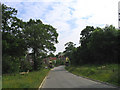
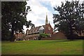
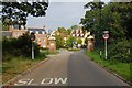
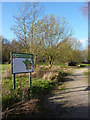
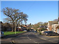
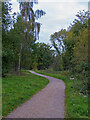
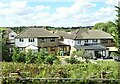
CM14 5WB is a small residential cluster located in the borough of Brentwood, Essex. This postcode covers an area of 1594 square metres and is home to 1448 people. Living here means residing in a district ward known as Warley, which sits south of the town centre and adjoins parts of Great Warley village. The neighbourhood is characterised by suburban development with rural elements, featuring estates such as Clements Park and Warley Mount amid green spaces. The area benefits from a strategic location near the M25 London Orbital Motorway and the Great Eastern Main Line. Residents enjoy a lifestyle that balances proximity to Greater London with the quiet of wooded higher ground. The vicinity includes significant natural sites like Warley Country Park and Hampden Wood, offering local recreational opportunities. Churches, including Christ Church and Holy Cross and All Saints, along with historic pubs like the Essex Arms, contribute to the established character of the ward. Buying a home in this specific stretch offers access to a community shaped by medieval history yet modernised by post-1840 railway development. You will find yourself on a road network that touches the boundary with Hornchurch, providing easy access to wider commuting routes while maintaining a local, residential feel.
- Area Type
- Postcode
- Area Size
- 1594 m²
- Population
- 1448
- Population Density
- 3842 people/km²
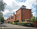
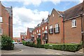
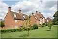
Homes in CM14 5WB are situated within a market defined by high owner-occupation and established stock. With 65 per cent of properties owner-occupied, this is a stable area where residents have a long connection to their homes. Houses are the primary accommodation type, meaning you will encounter family-sized dwellings rather than flats or purpose-built blocks. The area expanse of 1594 square metres indicates a compact residential zone, suggesting the housing stock is likely concentrated in established estates like those found along Warley Hill. The prominence of specific estates such as Clements Park, Warley Mount, and Hartswood suggests that properties here have distinct identities and histories, often built post-1840 or during later redevelopment of the area. New listings may be rare due to the low stock turnover associated with such high ownership rates. Buyers considering this postcode should expect a market focused on existing homes rather than new builds. The property landscape is anchored by the suburb of Warley, which includes a mix of housing attached to the former barracks site and other developed zones. Understanding the local market requires looking at these specific estates, as they define the practical reality of buying and living in CM14 5WB.
House Prices in CM14 5WB
Showing 5 properties
| Address | Type | Beds | Baths | Last Sale Price | Last Sale Date | |
|---|---|---|---|---|---|---|
| 3 Drovers Mead, Warley, CM14 5WB | Semi-detached | 4 | 2 | £653,260 | Apr 2020 | |
| 5 Drovers Mead, Warley, CM14 5WB | Detached | 4 | - | £660,000 | Oct 2014 | |
| 1 Drovers Mead, Warley, CM14 5WB | Detached | 4 | 1 | £415,000 | Sep 2006 | |
| 9 Drovers Mead, Warley, CM14 5WB | Terraced | - | - | - | - | |
| 7 Drovers Mead, Warley, CM14 5WB | Terraced | - | - | - | - |
Energy Efficiency in CM14 5WB
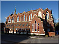
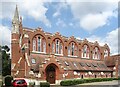
Living in CM14 5WB offers convenient access to a range of amenities within practical reach. There are five retail venues nearby, including major supermarkets like Tesco Warley, Waitrose Little, and Tesco Brentwood, ensuring daily shopping needs are met easily. For commuters and passengers, five rail stations and three metro stations provide regular public transport options from Brentwood Railway Station, Harold Wood Station, and Hornchurch. Green spaces form a significant part of the lifestyle, with Warley Country Park and Hampden Wood offering substantial open areas for recreation and walking. Cultural and community life is centred around local landmarks such as Spire Hartswood Hospital, which opened in 1984, and historic venues like the Essex Regiment Chapel. Dining and leisure options include the Essex Arms and the Brave Nelson pubs. Educational facilities are nearby, with Warley Primary and Holly Trees Primary catering to local families. The presence of churches such as Christ Church and Holy Cross and All Saints adds to the community fabric. You will find that daily life here is supported by a mix of essential services and leisure opportunities, all located close to the residential clusters of the ward.
Amenities
Schools
| Rank | School | Type | Entry gender | Ages |
|---|
Explore more schools in this area
Go to Schools tabDemographics
The community within CM14 5WB reflects a settled, mature population with a median age of 47 years. The majority of residents fall into the adult age range of 30 to 64 years, indicating a neighbourhood dominated by families and established households. House ownership is the norm, with 65 per cent of properties occupied by their owners. This high level of tenure stability suggests a long-term community where residents have roots in the area. Houses are the predominant form of accommodation, fitting the suburban and semi-rural character of the ward. The predominant ethnic group is White, aligning with the historical settlement patterns of the region. The population density is extremely high for a specific postcode, yet this reflects the nature of granular data rather than a crowded street layout. You will find a demographic profile suited to those seeking stability rather than a transient housing market. The age profile implies schools nearest the area cater largely to primary-aged children, given the median age and the presence of institutions like Warley Primary. This demographic structure supports a quiet, family-oriented atmosphere where neighbours often know one another through shared historic estates and local churches.
Household Size
Accommodation Type
Tenure
Ethnic Group
Religion
Household Composition
Age
Household Deprivation
NS-SEC
Explore more demographic insights in this area
Go to Demographics tabPlanning
Planning Constraints
- Flood RiskPremium
- Ramsar Wetland SitesPremium
- Area of Outstanding Natural BeautyPremium
- Protected Nature ReservePremium
- Protected WoodlandPremium