Area Overview for CM14 5NB
Photos of CM14 5NB


Area Information
CM14 5NB lies in the Brizes, Stondon Massey & South Weald ward of Brentwood, Essex, a small residential cluster with a population of 2012 and a density of 169 people per square kilometre. This area blends historical significance with modern convenience, situated near the village of South Weald and surrounded by rural landscapes. The community is anchored by its 12th-century church, St Peter’s & St Paul’s, and historic sites like Stondon Hall, reflecting centuries of Saxon and Norman influence. Daily life here is shaped by proximity to local amenities, including retail outlets, rail stations, and the village green, which hosts annual fairs. The area’s compact size fosters a tight-knit feel, with residents often walking or cycling to nearby services. While it lacks large urban hubs, its location offers easy access to Brentwood’s town centre and commuter routes to London via Shenfield and Harold Wood stations. For those seeking a quieter, historically rich environment with practical connectivity, CM14 5NB provides a distinctive blend of heritage and accessibility.
- Area Type
- Postcode
- Area Size
- Not available
- Population
- 2012
- Population Density
- 169 people/km²
CM14 5NB is primarily an owner-occupied area, with 81% of homes owned by residents rather than rented. The accommodation type is predominantly houses, which is typical for rural and semi-rural postcode areas in England. This suggests a housing stock that caters to families and individuals seeking more space than flats. The small size of the area means the property market is limited, with buyers likely needing to consider nearby postcodes for a wider selection. The high proportion of owner-occupied homes indicates a stable market with less turnover, which can be advantageous for long-term investors. However, the lack of rental properties may limit options for those seeking short-term or flexible housing. The presence of historical and architectural features, such as Stondon Hall and Brizes Park, could also influence property values, appealing to buyers interested in heritage or character homes.
House Prices in CM14 5NB
Showing 1 properties
| Address | Type | Beds | Baths | Last Sale Price | Last Sale Date | |
|---|---|---|---|---|---|---|
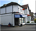
| Toomey Vauxhall, 59 Brook Street, Brentwood, CM14 5NB | office_workshop | - | - | - | - |
Energy Efficiency in CM14 5NB
The lifestyle in CM14 5NB is characterised by a mix of local amenities and historical attractions. Nearby retail options include Tesco Brentwood, Waitrose Little, and Tesco Warley, providing everyday shopping needs. The area’s proximity to rail and metro stations facilitates access to larger towns for dining, leisure, and cultural activities. Historic sites like St Peter’s Church and Stondon Hall add a sense of heritage, while the village green hosts community events such as annual fairs. The compact nature of the area encourages walking or cycling to local services, fostering a sense of community. Residents also benefit from the surrounding rural environment, which offers green spaces and a quieter alternative to urban life. The blend of practical amenities and historical charm creates a lifestyle that appeals to those seeking a balanced, accessible yet tranquil existence.
Amenities
Schools
The nearest school to CM14 5NB is St Peter’s Church of England Voluntary Aided Primary School in South Weald, which holds an outstanding Ofsted rating. This school serves the local community with a focus on primary education, providing a high standard of teaching and facilities. The absence of secondary schools in the immediate area means families may need to consider nearby postcodes for secondary education, though Brentwood town centre offers comprehensive options. The presence of an outstanding primary school is a significant advantage for parents prioritising quality education, as it reduces the need for long commutes. However, the limited range of school types in the vicinity may necessitate planning for additional educational needs beyond primary level.
| Rank | School | Type | Entry gender | Ages |
|---|
Explore more schools in this area
Go to Schools tabDemographics
The population of CM14 5NB has a median age of 47, with the majority aged between 30 and 64 years. This suggests a community skewed towards middle-aged adults, likely including families and professionals. Home ownership is high at 81%, indicating a stable, long-term resident base. The area is predominantly composed of houses rather than flats, aligning with the demographic profile of older, established households. The predominant ethnic group is White, reflecting the broader trends in rural Essex. While no specific deprivation data is provided, the high home ownership and moderate population density imply a relatively affluent, settled community. The absence of significant demographic diversity may mean fewer cultural amenities or services catering to a broader range of needs. However, the presence of a primary school with an outstanding Ofsted rating suggests a focus on family-friendly infrastructure.
Household Size
Accommodation Type
Tenure
Ethnic Group
Religion
Household Composition
Age
Household Deprivation
NS-SEC
Explore more demographic insights in this area
Go to Demographics tabPlanning
Planning Constraints
- Flood RiskPremium
- Ramsar Wetland SitesPremium
- Area of Outstanding Natural BeautyPremium
- Protected Nature ReservePremium
- Protected WoodlandPremium