Area Overview for CM13 3NR
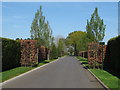
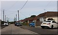
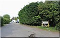
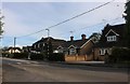
Photos of CM13 3NR

Area Information
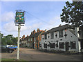
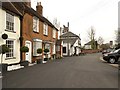
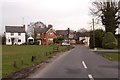
Living in CM13 3NR offers a tranquil existence within the civil parish of Herongate and Ingrave. This specific postcode covers a small residential cluster located approximately two miles south of Brentwood in the district of Essex. The area was formed in May 2003 from the former separate parishes of Ingrave and Herongate. Thameside lies along the A128 road, connecting Brentwood to West Horndon. Herongate sits between the main road and the village of Ingrave, which is found alongside Thorndon Hall park. The community possesses Anglo-Saxon origins, with Ingrave recorded in the Domesday Survey of 1086 and Herongate dating back to the Saxon period under the Heron family. Historical landmarks such as the Grade II listed Boar's Head pub and the Grade II listed Heron Hall define the local character. You will find yourself in an environment where history meets modern convenience. The population stands at 2162 people, creating a close-knit feel. Properties here are detached or semi-detached houses rather than flats. The area benefits from a safety score of 81 out of 100, indicating a secure neighbourhood. Digital infrastructure supports remote working with a broadband quality score of 92 and a mobile coverage score of 85. These factors combine to make CM13 3NR a practical choice for those seeking quiet living near the M25 without the noise of a busy junction.
- Area Type
- Postcode
- Area Size
- Not available
- Population
- 2162
- Population Density
- 177 people/km²
The property market in CM13 3NR is characterised by established owner-occupied homes. Eighty-five per cent of residents own their homes, creating a landscape defined by stability rather than transient renting. The accommodation type is strictly houses, so you will not encounter apartments or flats within this specific postal code. This concentration of single-family dwellings is typical of civil parishes formed from historic rural settlements like Herongate and Ingrave. The market reacts strongly to family demand because the housing stock is designed for families rather than single professionals. Buyers looking at CM13 3NR face a competitive environment where local knowledge is essential due to the small cluster size. High home ownership rates often correlate with stronger local investment and slower price volatility compared to letting markets. The presence of significant historic landmarks, such as the Grade II listed Heron Hall and Boar's Head pub, adds a layer of prestige and character to the properties. These landmarks attract buyers who value heritage and architectural distinctiveness over modern speculative buildings. The low population density of 177 people per square kilometre supports the idea of spacious gardens and private outdoor areas. This market structure means that transactions are likely between owner-occupiers, fostering a sense of community investment in property maintenance and improvement.
House Prices in CM13 3NR
No properties found in this postcode.
Energy Efficiency in CM13 3NR
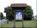
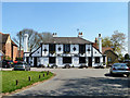
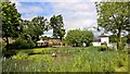
Daily life in CM13 3NR depends on a mix of local charm and access to nearby towns. Retail options include five key outlets within practical reach, such as M&S Ingrave BP, Tesco Brentwood, and Tesco Warley. These provide everything from daily groceries to major appliance shopping. For rail travel, five stations are nearby, with Brentwood Railway Station providing a direct link to central London. You can also reach Shenfield Railway Station and West Horndon Railway Station for alternative routes. The local Metro network includes Upminster Bridge, offering further travel flexibility. Beyond shopping, the area boasts significant green spaces, including Thorndon Hall park. The Boar's Head pub, originally three Tudor cottages from the Tyrell era, overlooks the village pond near Button Common, offering a traditional social spot. Herongate lies on the A128, making car-free access to Brentwood and West Horndon viable. The area contains Grade II listed buildings like Heron Hall, adding a cultural dimension to leisure walks. Napoleon's war horse Marengo was once kept at the Herongate estate, adding historical intrigue to local tours. These amenities create a lifestyle where residents can enjoy rural quiet while remaining within a short drive of town centre necessity.
Amenities
Schools
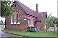
Families residing in CM13 3NR have access to specific educational institutions within practical reach. The nearest primary school is Ingrave Johnstone Church of England Voluntary Aided Primary School. This institution holds an Ofsted rating of Good, indicating reliable educational standards. As there are no secondary schools or nurseries listed in the immediate vicinity, residents must consider transport links for older children or younger infants. The reliance on a single named primary school suggests a focused local education offer rather than a diverse multi-school catchment. For you, this means checking the specific catchment boundaries for Ingrave Johnstone to ensure eligibility for your child. The Good rating reassures parents regarding curriculum quality and school conditions. While the data only provides one school, the location near Thorndon Hall park often supports active school grounds and local events. The history of education in the area dates back to the 19th century when the Petre family fostered local schools. This long history implies a strong tradition of supporting learning in the parish. Parents should verify current enrolment numbers and transport arrangements for parish churches and surrounding farms which often influence school zoning.
| Rank | School | Type | Entry gender | Ages |
|---|
Explore more schools in this area
Go to Schools tabDemographics
The community in CM13 3NR reflects a settled population with clear demographic markers. The median age is 47 years, indicating that the neighbourhood is predominantly populated by adults between 30 and 64 years old. This age profile suggests stability and a family-oriented or retirement demographic rather than a transient student population. Home ownership is high at 85 per cent, meaning most residents own their residences outright or with a mortgage rather than renting. This high level of tenure points to a community that has stayed in the area for long periods. The predominant ethnic group is White, consistent with the broader patterns of Essex and the South East. Accommodation types are exclusively houses, distinguishing this postcode from urban areas filled with apartments or flats. These concrete figures describe a demographic landscape built on permanence and home ownership. Such statistics correlate with specific benefits like lower noise levels, better schools, and more mature landscapes. The population density is 177 people per square kilometre, ensuring a spread-out feel where neighbours are visible but not intrusive. For you, this translates to a living environment where the community is defined by shared values and long-term residency patterns rather than rapid turnover.
Household Size
Accommodation Type
Tenure
Ethnic Group
Religion
Household Composition
Age
Household Deprivation
NS-SEC
Explore more demographic insights in this area
Go to Demographics tabPlanning
Planning Constraints
- Flood RiskPremium
- Ramsar Wetland SitesPremium
- Area of Outstanding Natural BeautyPremium
- Protected Nature ReservePremium
- Protected WoodlandPremium