Area Overview for CM13 3LJ
Photos of CM13 3LJ
Area Information
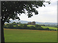
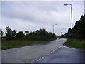
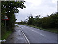
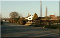
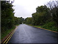
Living in West Horndon offers a quieter alternative to larger Essex towns, defined by a distinct village character within the Borough of Brentwood. This specific postcode area covers 11.5 hectares and serves approximately 1,649 residents, creating a low-density environment where neighbours are rarely far away.Originally, West Horndon functioned as a single parish with connection to its historical estate, Thorndon Park, the former seat of the Lord Petre. While the civil parish boundaries were adjusted in 2003 following resident petitions, the area retains its rural identity through a mix of older housing and 1950s developments. Streets such as Fyfield Close and Dunmow Gardens wind through meandering cul-de-sacs that line the railway track, separating these residential zones from the industrial estate on Station Road. As a commuter settlement, the area grew significantly during the mid-20th century to house Rotary Hoes workers before shifting towards retirement homes fitful of the 84% ownership rate today. The village sits roughly 20 miles east-northeast of Charing Cross, positioned conveniently between Brentwood and Laindon. For those seeking homes in West Horndon, the trade-off between proximity to a railway line and the resulting village seclusion defines daily life. Residents enjoy a social circle that has evolved from agricultural roots to a modern community centred around West Horndon Primary School. This specific location balances historical depth with practical accessibility to Basildon and Chelmsford, making it a stable choice for settled families and retirement alike.
- Area Type
- Postcode
- Area Size
- 11.5 hectares
- Population
- 1649
- Population Density
- 216 people/km²
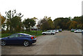
The housing market in West Horndon presents a predominantly owner-occupied landscape, with 84% of homes held by their owners. This statistic defines the local real estate dynamics, as there are very few空置 rental properties available in this small postcode cluster. Accommodation types focus heavily on houses, reflecting the village's evolution from its agricultural roots through the post-war expansion of the 1950s. Buyers should expect to find semi-detached and detached homes in meandering streets like Dunmow Gardens and Fyfield Close rather than large apartment complexes. With a population of only 1,649 spread across 11.5 hectares, this area does not offer the high-turnover inventory seen in larger towns. The presence of an industrial estate on Station Road and proximity to the railway line has historically supported working-class families, leaving a legacy of practical, family-sized properties. Consequently, the property market here functions differently from regional hubs. Competition for homes in West Horndon is often fierce due to limited supply, driven by the strong desire for owner-occupation in a secure, low-density setting. For investors, the high ownership rate suggests a mature market where rent yields may be lower but stability is higher. For buyers seeking purchase opportunities, the inventory is small and specific to the village character. The mix of 1950s estates and older housing near Thorndon Park provides variety, but all options strictly align with the house-dominated stock.
House Prices in CM13 3LJ
Showing 2 properties
| Address | Type | Beds | Baths | Last Sale Price | Last Sale Date | |
|---|---|---|---|---|---|---|
| 1, Keepers Cottages, Southend Arterial Road, West Horndon, CM13 3LJ | Detached | 6 | 1 | - | - | |
| 2, Keepers Cottages, Southend Arterial Road, West Horndon, CM13 3LJ | Semi-detached | - | - | - | - |
Energy Efficiency in CM13 3LJ
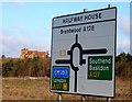
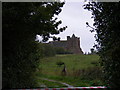
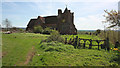
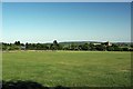
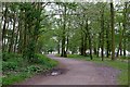
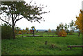
Daily life in West Horndon revolves around a blend of village convenience and access to broader retail and leisure centres. Retail options are spread across five nearby locations, with Morrisons Daily West, M&S Ingrave BP, and Tesco Basildon serving practical shopping needs within practical reach. These venues handle everything from daily groceries to household essentials, reducing the need for frequent trips into larger towns. For rail enthusiasts, nearby stations include West Horndon Railway Station, Laindon Railway Station, and Brentwood Railway Station, facilitating easy travel to Brentwood and London via Upminster Bridge. The local amenities cater to standard residential requirements without the density of a city centre. Thorndon Park, historically significant as the seat of the Fitzwalters and Lord Petre, anchors the southern edge of the parish and offers a touch of historical architecture with its Roman Catholic chapel. While housing estates and an industrial estate dominate the Station Road corridor, the residential clusters retain a rural feel through their named streets and cul-de-sacs. Residents enjoy a lifestyle defined by proximity to essential services rather than a plethora of entertainment venues. The lack of protected nature reserves or woodlands means the area is built out, yet the original 470-acre footprint of the parish leaves traces in the surrounding landscape. Living here means prioritising community access over urban spectacle.
Amenities
Schools
Education provision for children in West Horndon is centred on specific facilities that serve the village's family demographic. West Horndon Primary School stands as the key educational institution, holding a good Ofsted rating. As a primary school, it covers the early years of learning for children growing up in the four distinct age ranges that populate the local authority area. The school sits within the Brentwood County High catchment area, providing a clear pathway for students wishing to continue their education locally upon reaching secondary age. There are no secondary or further education institutions listed directly within this 11.5-hectare residential cluster. This structure means that once children finish their primary education at West Horndon Primary School, they must commute to other schools outside the immediate village. The mixed age profile of residents, particularly the concentration of adults between 30 and 64 years old, ensures a steady intake of learners into the local primary system. Parents relocating to West Horndon should note that their initial school choice will be fixed by the proximity to the only listed primary provider. The good rating of the school offers reassurance on the quality of early education, though the lack of secondary options represents a standard characteristic for rural village postcodes in the Borough of Brentwood. ”
| Rank | School | Type | Entry gender | Ages |
|---|
Explore more schools in this area
Go to Schools tabDemographics
The community in West Horndon is characterised by stability and maturity, reflected in a median age of 47 years. Most residents fall into the 30-64 age bracket, indicating a preferred demographic for those who have established their careers or are raising young families. The vastly predominant ethnic group is White, which aligns with the area's historical development and local composition. A notable 84% of households own their property, creating a community where long-term investment and generational ties are common rather than temporary tenancy. This high level of home ownership correlates directly with the prevalence of houses as the primary accommodation type. Social housing is minimal within this 11.5-hectare cluster, meaning the local character is defined by private gardens and established gardens rather than panel-block estates. The population density of 216 people per square kilometre ensures that the village retains a breathable atmosphere without the congestion typically found in urban boroughs. You will find fewer transient populations here, as the cost of establishing ownership combined with the lack of rental properties filters for residents who intend to stay. This demographic stability means local schools and village amenities cater to established family units rather than a revolving door of tenants. The range suggests a quiet, predictable environment where local issues remain local concerns, far from the volatile demographic shifts seen in rapidly gentrifying urban zones.
Household Size
Accommodation Type
Tenure
Ethnic Group
Religion
Household Composition
Age
Household Deprivation
NS-SEC
Explore more demographic insights in this area
Go to Demographics tabPlanning
Planning Constraints
- Flood RiskPremium
- Ramsar Wetland SitesPremium
- Area of Outstanding Natural BeautyPremium
- Protected Nature ReservePremium
- Protected WoodlandPremium