Area Overview for CM13 1UD
Photos of CM13 1UD


Area Information
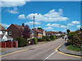
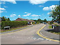
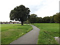
Hutton North Ward, accessible via the CM13 1UD postcode, sits on the eastern edge of Brentwood, Essex. This residential cluster forms a small but settled community with a population of 1,546. The area lies approximately three miles east of Brentwood town centre, situated on the eastern edge of the built-up area. The name Hutton derives from a farm or settlement on a hill spur, reflecting its rural origins despite its proximity to the urban district. Documents and research place this ward firmly within the Barstable Hundred history, eventually merging with Shenfield and other areas to form the urban district of Brentwood in 1934. Residents here enjoy the benefits of a suburb that balances historical depth with modern accessibility. The setting offers a residential atmosphere away from the immediate bustle of the main town centre while maintaining close links to local commerce and culture. Living in CM13 1UD means residing in an area with documented connections back to the Domesday Book of 1086, when the settlement included 24 households under the ownership of Battle Abbey. This historical context provides a stable backdrop for daily life, supported by established facilities like the parish church and local learning centres that serve the wider Mid Essex community.
- Area Type
- Postcode
- Area Size
- Not available
- Population
- Not available
- Population Density
- Not available
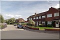
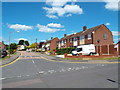
Homes in CM13 1UD are characterised by a strong inclination towards residential properties rather than high-rise blocks or estates. The accommodation type data confirms that Houses form the primary stock, which is typical for a suburb on the edge of an urban district. With a home ownership rate of 44%, this area sits slightly below the national average, suggesting a mixed market where both owners and landlords coexist. This ratio indicates that while there is a substantial base of owner-occupiers, there is also a healthy segment of rental properties available. For buyers looking at this small area and its immediate surroundings, the housing stock will predominantly feature traditional house types rather than flats or modern developments. The historical context of Hutton, which dates back to the 19th century and beyond, suggests that much of the existing housing may have undergone various modifications over time. Prospective purchasers should expect a range of property ages, from mid-20th century builds to older, historically significant homes. The focus on houses also means that shared gardens and direct access to outdoor space are common features for residents in this postcode.
House Prices in CM13 1UD
No properties found in this postcode.
Energy Efficiency in CM13 1UD
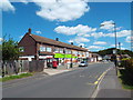
Residents of CM13 1UD benefit from practical amenities within easy reach, combining local conveniences with access to larger town centres. Retail options include five noted outlets, with Co-op Rayleigh, Chelmsford Star Co-operative Society Co, and Tesco Brentwood serving as key destinations for groceries and daily goods. These shops provide a spread of retail choices without requiring lengthy commutes for basic necessities. Transport connectivity is equally robust, with five nearby railway stations facilitating travel across the county and nation. Shenfield Railway Station, Ingatestone Railway Station, and Brentwood Railway Station offer reliable rail links for commuting to London или domestic travel. The presence of these stations places CM13 1UD in a framework of excellent accessibility compared to more isolated rural spots. Amenities and transport infrastructure here work together to create a lifestyle that balances suburban comfort with urban efficiency. You can shop at a local Co-op or travel via train to the city centre without carrying a car for every journey. This mix of retail variety and rail access defines the daily rhythm for households in Hutton.
Amenities
Schools
Families living in CM13 1UD have access to specific educational institutions within the local vicinity. Hutton All Saints Church of England Primary School serves as the noted primary school option for the area. This institution holds an Ofsted rating of good, which indicates it meets the expected standards for educational provision. The presence of a church of England school suggests a specific theological orientation, though the school's academic standing remains rated positively. There are no comprehensive schools or nurseries listed in the immediate data for this specific postcode cluster, meaning parents may need to look to the wider Brentwood or Billericay areas for secondary education or for younger children. The reliance on a single named primary school in the dataset implies that this school plays a central role for local education. For those researching schools near CM13 1UD, Hutton All Saints is the only facility with a defined Ofsted grade provided in the current information. The proximity of a good-rated primary school adds stability for families seeking education within a reasonable drive or walk from their homes in Hutton.
| Rank | School | Type | Entry gender | Ages |
|---|
Explore more schools in this area
Go to Schools tabDemographics
The community in CM13 1UD reflects a settled demographic with a median age of 47 years. Adults between the ages of 30 and 64 represent the most common age range within the population. This age profile suggests a neighbourhood favoured by established families and professionals rather than young singles or empty nesters. Home ownership stands at 44%, indicating that slightly less than half of the residents own their properties outright. The remaining households likely fall into the rental or shared ownership sectors, though data on specific tenure types beyond this percentage is not detailed in this overview. The predominant ethnic group in this postcode area is White, consistent with the broader demographic makeup of many historic Essex towns. Accommodation types are primarily Houses, meaning detached, semi-detached, or terraced properties dominate the streetscape alongside houses in multiple occupation. There are no official figures on the split of single versus family homes, but the prevalence of houses supports the inference of significant family presence. The community lacks data on specific deprivation indices in the provided set, so general statements about economic hardship are not possible here.
Household Size
Accommodation Type
Tenure
Ethnic Group
Religion
Household Composition
Age
Household Deprivation
NS-SEC
Explore more demographic insights in this area
Go to Demographics tabPlanning
Planning Constraints
- Flood RiskPremium
- Ramsar Wetland SitesPremium
- Area of Outstanding Natural BeautyPremium
- Protected Nature ReservePremium
- Protected WoodlandPremium