Area Overview for CM0 8AF
Photos of CM0 8AF

Area Information
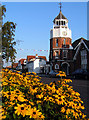
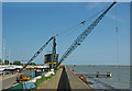
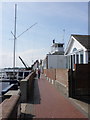
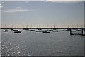
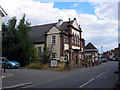
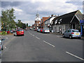
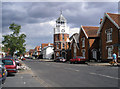
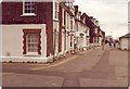
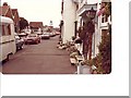
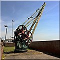
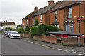
CM0 8AF, part of Burnham-on-Crouch in Essex, is a small coastal parish with a population of 1,589. It lies on the Dengie Peninsula, a historic settlement with roots in medieval times, known for its maritime heritage and yachting culture. The area blends medieval architecture, 18th- and 19th-century buildings, and Victorian expansion, earning it nicknames like “The Essex Cowes.” Daily life here is shaped by its nautical focus, with boatyards, yacht clubs, and seasonal events like Burnham Week regattas. The High Street hosts a mix of historic market sites and modern amenities, while the River Crouch offers scenic access to the North Sea. Though small, the parish is self-sufficient, with local shops, rail links, and ferry services connecting to nearby towns. Its compact size means residents often know their neighbours, and the community retains a traditional, maritime character. For those seeking a quiet, coastal lifestyle with a touch of history, CM0 8AF offers a unique blend of tranquillity and accessibility to larger regional hubs.
- Area Type
- Postcode
- Area Size
- Not available
- Population
- 1589
- Population Density
- 4536 people/km²
The property market in CM0 8AF is dominated by owner-occupied homes, with 59% of properties owned by residents. This suggests a stable, long-term demographic with limited turnover. The area is primarily composed of houses, which aligns with its semi-rural character and coastal setting. Given the small population and limited development, the housing stock is likely to be older, with a mix of traditional and more recent builds. The proximity to Burnham-on-Crouch’s historic core and the River Crouch may influence property values, with waterfront or high street locations commanding premium prices. For buyers, the small size of the area means competition for available homes could be fierce, particularly for properties with unique features like river views or historical significance. The lack of large-scale development also means the market remains relatively unchanged, offering a snapshot of a bygone era.
House Prices in CM0 8AF
No properties found in this postcode.
Energy Efficiency in CM0 8AF
Living in CM0 8AF offers access to a range of local amenities within walking or short driving distance. The High Street features shops like Tesco Burnham, Morrisons Daily Burnham On, and the East of England Co-operative, providing essentials for daily life. Rail services at Burnham and Southminster stations connect residents to nearby towns, while ferry access to Wallasea Island and Burnham Yacht Harbour adds a maritime dimension to leisure activities. The area’s historic character is complemented by its nautical focus, with yacht clubs, boatyards, and events like Burnham Week regattas. Parks and open spaces, though not explicitly named, are implied by the absence of planning constraints like AONB or protected woodlands. The blend of retail, transport, and maritime culture creates a lifestyle that balances tradition with practicality, ideal for those seeking a coastal community with strong local ties.
Amenities
Schools
| Rank | School | Type | Entry gender | Ages |
|---|
Explore more schools in this area
Go to Schools tabDemographics
CM0 8AF has a median age of 47, with the majority of residents aged 30–64. This suggests a mature, stable community with a focus on established families and professionals. Home ownership stands at 59%, indicating a mix of owner-occupied properties and rental stock. The area is predominantly White, with no specific data on other ethnic groups provided. Accommodation is largely composed of houses, reflecting a suburban or semi-rural character. The absence of detailed data on household types or deprivation levels means the area’s socioeconomic diversity remains unclear. However, the presence of rail stations, retail outlets, and ferry services suggests a moderate level of infrastructure to support daily needs. The population size of 1,589 implies a tight-knit community, where local amenities and social networks likely play a significant role in quality of life.
Household Size
Accommodation Type
Tenure
Ethnic Group
Religion
Household Composition
Age
Household Deprivation
NS-SEC
Explore more demographic insights in this area
Go to Demographics tabPlanning
Planning Constraints
- Flood RiskPremium
- Ramsar Wetland SitesPremium
- Area of Outstanding Natural BeautyPremium
- Protected Nature ReservePremium
- Protected WoodlandPremium