Area Overview for Chelmondiston
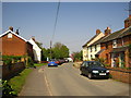
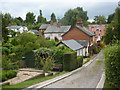
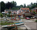
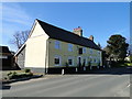
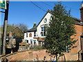
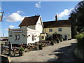
Photos of Chelmondiston


Area Information
Chelmondiston is a compact built-up area in England, covering 48.9 hectares. Its population, while not explicitly stated, is reflected in its median age of 70, suggesting a community skewed toward older residents. The area’s character is defined by its proximity to key transport links and amenities, making it accessible yet distinct. Residents benefit from nearby rail services, including Harwich International and Wrabness stations, which connect to broader regional networks. For those seeking coastal access, ferry services to Harwich, Felixstowe, and Shotley Point provide direct links to the North Sea. Daily life here balances practicality with connectivity, with retail options like Makro Ipswich and East of England Co-operative Co within reach. The presence of two primary schools, including one with a ‘good’ Ofsted rating, underscores the area’s appeal to families. While the data does not specify local landmarks or historical context, Chelmondiston’s blend of transport infrastructure and community-focused amenities positions it as a functional, if unassuming, place to live.
- Area Type
- Built Up Area 250
- Area Size
- 48.9 hectares
- Population
- Not available
- Population Density
- Not available
Residents of Chelmondiston have access to retail options such as Makro Ipswich and East of England Co-operative Co, providing shopping and grocery services. The area’s rail stations connect to broader networks, while ferry services offer direct links to coastal destinations. Though no parks or leisure facilities are listed in the data, the presence of multiple retail and transport hubs suggests a lifestyle focused on convenience and accessibility. The availability of primary schools and nearby transport links may appeal to families seeking practical living conditions. However, the absence of specific details on leisure or recreational spaces means the area’s character beyond its functional amenities remains unclear.
Amenities
Schools
Chelmondiston has two primary schools within its vicinity: Chelmondiston Church of England Voluntary Controlled Primary School and Chelmondiston Church of England Primary School. The latter holds a ‘good’ Ofsted rating, indicating a school that meets standards in teaching and pupil outcomes. Both institutions serve the local community, offering education for younger children. The presence of two primary schools, even if not explicitly linked to the area, suggests accessibility for families. While no secondary schools are listed, the availability of primary education may influence decisions for parents prioritising early schooling. The data does not indicate school catchment areas or performance metrics beyond the Ofsted rating, so further local research would be necessary for a full assessment.
| Rank | A + A* % | School | Type | Entry gender | Ages |
|---|---|---|---|---|---|
| 1 | N/A | Chelmondiston Church of England Voluntary Controlled Primary School | primary | N/A | N/A |
| 2 | N/A | Chelmondiston Church of England Primary School | primary | N/A | N/A |
Explore more schools in this area
Go to Schools tabDemographics
Chelmondiston’s population has a median age of 70, with the most common age range encompassing the total population. This suggests a community where older residents form a significant proportion. Home ownership stands at 69%, indicating a majority of residents live in properties they own rather than rent. The data does not specify household composition or accommodation types, but the overall figures imply a stable, settled population. The absence of detailed breakdowns on ethnicity or religion means no conclusions can be drawn about diversity or cultural composition. For those considering quality of life, the home ownership rate and age profile suggest a community with established residents, though further data would be needed to assess social dynamics or deprivation levels.
Household Size
Accommodation Type
Tenure
Ethnic Group
Religion
Household Composition
Age
Household Deprivation
NS-SEC
Explore more demographic insights in this area
Go to Demographics tabPlanning
Planning Constraints
- Crime RiskLocked