Area Overview for CB9 7HG
Photos of CB9 7HG
Area Information
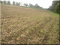
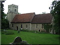
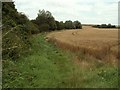
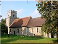
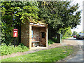
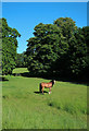
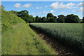
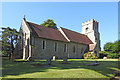
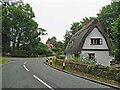
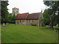
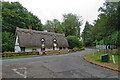
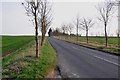
Living in CB9 7HG, a small rural postcode in Suffolk, offers a quiet, community-focused lifestyle. The area covers 78 hectares and is home to 2,581 people, with a population density of 44 people per square kilometre. This postcode encompasses the village of Great Wratting, a historic settlement with a ford across the River Stour and a mix of traditional thatched cottages and newer homes. The village retains a village green, a 16th-century church, and a thriving pub, the Red Lion, which hosts local events like the annual summer fete. Residents benefit from proximity to Haverhill, just four miles away, while the surrounding landscape includes fields and woods. The area’s character is defined by its rural charm, historical ties to the Domesday Book, and a population skewed towards adults aged 30–64. Daily life here balances small-town convenience with access to nearby amenities, making it appealing for those seeking a slower pace of life without complete isolation.
- Area Type
- Postcode
- Area Size
- 78.0 hectares
- Population
- 2581
- Population Density
- 44 people/km²
The property market in CB9 7HG is dominated by owner-occupied homes, with 70% of properties owned by residents rather than rented. The area’s accommodation type is primarily houses, which aligns with its rural setting and the presence of older, thatched cottages on the Thurlow Estate. This suggests a market skewed towards family homes and long-term residents rather than short-term rentals or high-density housing. The small size of the postcode—78 hectares—means the housing stock is limited, with fewer options for buyers compared to larger urban areas. Proximity to Haverhill may offer additional choices for those seeking more variety, but within CB9 7HG itself, properties are likely to be distinct and individual, reflecting the village’s character. Buyers should consider the area’s limited expansion potential and the importance of local amenities in maintaining property value.
House Prices in CB9 7HG
Showing 12 properties
| Address | Type | Beds | Baths | Last Sale Price | Last Sale Date | |
|---|---|---|---|---|---|---|
| 82 Thurlow Road, Great Wratting, CB9 7HG | Detached | 5 | 2 | £517,000 | Dec 2019 | |
| The Shelter, 80-81 Thurlow Road, Great Wratting, CB9 7HG | Terraced | 3 | - | - | - | |
| 86 Thurlow Road, Great Wratting, CB9 7HG | house | - | - | - | - | |
| Hill Farm, Thurlow Road, Great Wratting, CB9 7HG | Farm | - | - | - | - | |
| Pelican House Farm, Thurlow Road, Great Wratting, CB9 7HG | house | - | - | - | - | |
| 85 Thurlow Road, Great Wratting, CB9 7HG | house | - | - | - | - | |
| 84 Thurlow Road, Great Wratting, CB9 7HG | house | - | - | - | - | |
| 83 Thurlow Road, Great Wratting, CB9 7HG | house | 3 | 1 | - | - | |
| 87 Thurlow Road, Great Wratting, CB9 7HG | Detached | - | - | - | - | |
| The Fells, Thurlow Road, Great Wratting, CB9 7HG | house | - | - | - | - |
Energy Efficiency in CB9 7HG
The lifestyle in CB9 7HG is shaped by its rural setting and small-village character. Nearby amenities include retail options like Spar, Tesco Haverhill, and Aldi Haverhill, accessible within a short drive. The village itself features a pub, the Red Lion, which serves as a social hub, and St Mary’s Church, a historic site with Saxon origins. Residents can enjoy the village green, where events like the annual summer fete take place, and the River Stour ford, which supports local activities like fishing. The area’s charm lies in its mix of traditional architecture, including thatched cottages and older buildings repurposed as homes. While the immediate area has limited retail and dining options, the nearby town of Haverhill provides more extensive facilities. This balance of rural tranquillity and access to nearby services makes CB9 7HG appealing for those valuing community and natural surroundings.
Amenities
Schools
Residents of CB9 7HG have access to two schools within practical reach. Thurlow Voluntary Controlled Primary School provides primary education and holds a ‘good’ Ofsted rating, indicating a reliable foundation for younger children. Broadlands Hall, a special school, also has a ‘good’ rating, offering tailored support for students with specific needs. The combination of a primary school and a special school suggests a comprehensive educational environment for families, though the absence of secondary schools means older students may need to travel to Haverhill or nearby towns. This mix of school types ensures that both general and specialist education is available, though parents should plan for commuting beyond the immediate area for secondary schooling.
| Rank | School | Type | Entry gender | Ages |
|---|
Explore more schools in this area
Go to Schools tabDemographics
The population of CB9 7HG has a median age of 47, with the majority of residents falling into the 30–64 age range. This suggests a community of established adults, many of whom may be homeowners, as 70% of homes in the area are owner-occupied. The predominant accommodation type is houses, reflecting the rural nature of the postcode. The majority of residents identify as White, though specific data on other ethnic groups is not provided. The low population density—44 people per square kilometre—indicates a spread-out settlement with ample space between properties. This demographic profile suggests a stable, mature community with limited reliance on public services, though the exact impact on local infrastructure or social services is not quantified. The absence of detailed diversity statistics means the area’s cultural makeup remains less defined in the data.
Household Size
Accommodation Type
Tenure
Ethnic Group
Religion
Household Composition
Age
Household Deprivation
NS-SEC
Explore more demographic insights in this area
Go to Demographics tabPlanning
Planning Constraints
- Flood RiskPremium
- Ramsar Wetland SitesPremium
- Area of Outstanding Natural BeautyPremium
- Protected Nature ReservePremium
- Protected WoodlandPremium