Area Overview for CB8 8FR
Photos of CB8 8FR

Area Information
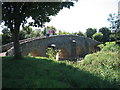
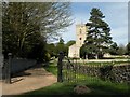
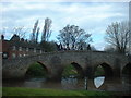
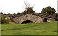
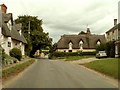
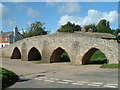
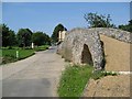
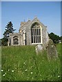
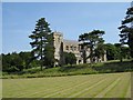
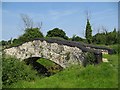
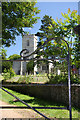
Moulton is a village and civil parish in West Suffolk, situated in eastern England close to the town of Newmarket. This specific postcode, CB8 8FR, covers a small residential cluster within this historic setting. The area contains a population of 2,252 people, spread across a low-density landscape with approximately 91 people per square kilometre. You will find yourself living in an environment that predates the Domesday Book of 1086, often described as a charming rural village nestled in the folds of the West Suffolk hills. While the surrounding town of Newmarket offers modern conveniences, CB8 8FR provides a quieter existence defined by its ancient roots and proximity to the River Kennett. The village features distinct landmarks such as a 15th-century packhorse bridge and St. Peter's Church, which feature a gilded weather vane in the shape of a pike. Daily life here balances the presence of local facilities like The Packhorse Inn and a football pitch with the tranquility of countryside living. The historic nature of the location, where the village is older than Newmarket itself, gives residents a deep connection to the past while maintaining easy access to regional centres.
- Area Type
- Postcode
- Area Size
- Not available
- Population
- 2252
- Population Density
- 91 people/km²
The property market in CB8 8FR is defined by a strong preference for traditional house ownership. With a home ownership rate of 75 percent, the area functions primarily as a market for prospective buyers seeking to purchase their own homes rather than a rental sector. The accommodation type data confirms that houses are the predominant dwelling style, meaning you are likely to explore listings of semi-detached or detached family homes rather than apartments or flats. This concentration of houses aligns with the village character and the demographic reality of a 47-year-old median age. For buyers looking at this small cluster, the market suggests stability and a lack of transient occupancy. The low population density of 91 people per square kilometre implies that housing options are spaced out, offering more land per property compared to urban districts. When viewing homes in this postcode, expect a landscape dominated by established residences that reflect the village's long history. The high ownership rate often means properties have been in the same families for generations, adding to the sense of permanence.
House Prices in CB8 8FR
No properties found in this postcode.
Energy Efficiency in CB8 8FR
Your daily life in CB8 8FR includes convenient access to essential amenities within practical reach. Retail options are backed by five nearby superstores and shops, including Spar, M&S Hyperion BP, and Waitrose Newmarket for higher-end grocery needs. Transport links are supported by five rail stations, with Kennett Railway Station, Entrance2, and Newmarket Railway Station located close by for travel to Cambridge and London. Beyond shopping and transport, the village offers cultural and leisure facilities such as The Packhorse Inn, a park, a football pitch, and a playground. St. Peter's Church and the historic 15th-century packhorse bridge provide significant aesthetic and historical interest during walks. The Moulton Pavilion offers a community gathering space for local events. This mix of practical services and historic landmarks creates a balanced environment where professional errands are manageable and leisure activities are embedded in the village architecture.
Amenities
Schools
Families living in CB8 8FR have access to a single specific educational institution within the immediate vicinity. Moulton Church of England Voluntary Controlled Primary School serves the local catchment and holds an outstanding Ofsted rating. This designation places the school in the highest performance category, offering a strong educational foundation for younger children. The lack of secondary schools within the provided data indicates that families must travel to nearby towns like Newmarket or Cambridge for older pupils, which is common for rural parishes in West Suffolk. The presence of an outstanding-rated primary school supports the area's appeal to parents who prioritise early education quality. With only one school listed, the educational provision is specialized for primary years, and older students integrate into the broader school system of West Suffolk. This setup requires parents to consider commuting times for teenagers but ensures that young children receive education from a highly rated local provider.
| Rank | School | Type | Entry gender | Ages |
|---|
Explore more schools in this area
Go to Schools tabDemographics
The community in CB8 8FR reflects a settled, mid-life demographic profile. The median age of residents is 47 years, with adults aged between 30 and 64 years constituting the most common age range. This age distribution suggests a neighbourhood favoured by professionals and established families rather than young people leaving their teenage years or the elderly relocating to care homes. Home ownership stands at 75 percent, indicating a stronghold of owner-occupied households where residents have invested long-term in their property. This high level of ownership correlates with an accommodation type predominantly consisting of houses, rather than purpose-built flats or high-density apartment blocks. The predominant ethnic group in the area is White, contributing to a homogenous community structure typical of many rural English villages. These demographic figures paint a picture of a stable residential zone where families and established couples form the core of society. The low population density further supports a lifestyle where community interactions occur through local institutions rather than transient high-street culture.
Household Size
Accommodation Type
Tenure
Ethnic Group
Religion
Household Composition
Age
Household Deprivation
NS-SEC
Explore more demographic insights in this area
Go to Demographics tabPlanning
Planning Constraints
- Flood RiskPremium
- Ramsar Wetland SitesPremium
- Area of Outstanding Natural BeautyPremium
- Protected Nature ReservePremium
- Protected WoodlandPremium