Area Overview for CB8 7RH
Photos of CB8 7RH
Area Information
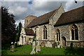
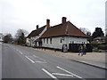
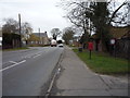
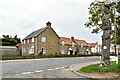
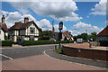
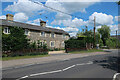
Living in CB8 7RH means residing in Kentford, a village and civil parish situated in the West Suffolk district. This specific postcode covers a small residential cluster that forms part of a community with an estimated population of 2,252 people. The area sits on the banks of the River Kennett along the B1506 road, positioning it approximately four miles northeast of Newmarket and nine miles west of Bury St Edmunds. Historical records indicate the location was first mentioned in the 11th century as Cheneteforde, referencing a ford across the river. Daily life here centres around a quiet, traditional atmosphere focused on the hilltop Church of St Mary, a 14th-century building that serves as the community hub. The village has grown from just twelve houses in 1674 to its current moderate size, retaining a close-knit character despite boundary changes in 1984 that added housing from Moulton parish. Families and individuals seeking a village setting with historical depth will find a home in this location. The community actively maintains local events, supported by a parish that has overcome past challenges to remain vibrant.
- Area Type
- Postcode
- Area Size
- Not available
- Population
- 2252
- Population Density
- 91 people/km²
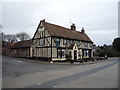
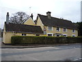
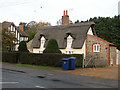
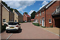
The property market in CB8 7RH is characterised by a strong owner-occupier base. With 75% of residents owning their homes, this postcode area operates distinctly as an owner-occupied community rather than a rental market. The predominant accommodation type consists of houses, which aligns with the village's development pattern following the 1984 boundary changes that incorporated new housing from Moulton. This housing stock reflects a shift from the village's original twelve houses in 1674 to a larger, more modernised settlement. Prospective buyers looking at homes in CB8 7RH will find an area where property values are likely influenced by local stability and the quality of life associated with high ownership rates. The fact that three-quarters of residents own their homes suggests that many properties are held long-term, often by those who grew up in Kentford or moved there for specific educational or family reasons. This stability supports the local economy and ensures that housing developments respect the area's historical character. When considering pixels in this small residential cluster, you are entering a market driven by investment and occupancy rather than short-term letting arrangements. The housing stock supports a lifestyle centred around the village green and the River Kennett, making it suitable for buyers seeking a permanent foothold in Suffolk.
House Prices in CB8 7RH
Showing 1 properties
| Address | Type | Beds | Baths | Last Sale Price | Last Sale Date | |
|---|---|---|---|---|---|---|
| Abacus Cards Ltd, Gazeley Road, Kentford, CB8 7RH | Industrial | - | - | - | - |
Energy Efficiency in CB8 7RH
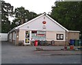
Daily life in CB8 7RH benefits from a cluster of amenities that meet the practical needs of residents. Within practical reach, there are five retail outlets, including notable venues such as Tesco Red, M&S Hyperion BP, and Spar. These shops provide essential goods, ranging from groceries and household items to fuel, ensuring that daily shopping trips require minimal travel time. Four railway stations are also listed as nearby transport hubs, reinforcing the area's accessibility for those working outside the village. The character of the area is shaped by its rural setting yet retained convenience. Residents enjoy the traditional atmosphere of Kentford while having access to modern conveniences like supermarkets and fuel stations. The presence of the River Kennett adds a natural element to the landscape, complementing the historic charm of the village. This blend of rural character and practical amenities makes the area suitable for families who value community interaction alongside functional services. The proximity to these specific retailers ensures that life in CB8 7RH remains convenient without the need for frequent car journeys to larger towns.
Amenities
Schools
Education options in the vicinity of CB8 7RH are anchored by a single primary institution. Moulton Church of England Voluntary Controlled Primary School serves as the nearest educational facility for children in this postcode. The school holds an outstanding Ofsted rating, indicating a high standard of education and care for students within this age group. For families living in CB8 7RH, this primary school offers a secure educational foundation. As the only listed school in the immediate data, it suggests that younger children attend this specific institution before potentially moving to secondary schools outside the immediate postcode boundaries. The outstanding rating provides confidence for parents choosing homes near CB8 7RH, ensuring that early years education is of a very high standard. The proximity of this primary school aligns with the demographic reality that the most common age group in the area comprises adults aged 30 to 64 years, fitting well with families raising young children.
| Rank | School | Type | Entry gender | Ages |
|---|
Explore more schools in this area
Go to Schools tabDemographics
The community in CB8 7RH is defined by a mature age profile. The median age stands at 47, with the most common age range being adults between 30 and 64 years. This demographic indicates a neighbourhood where established families and long-term residents form the backbone of local society. Home ownership is highly prevalent, with 75% of households owning their property outright or via a mortgage. This figure suggests a stable community with low tenant turnover and investment in local establishments. Accommodation types are dominated by houses, reflecting the village's suburban expansion and traditional layout rather than high-density urban living. The predominant ethnic group is White, aligning with the broader demographic trends of rural Suffolk. These statistics paint a picture of a settled, family-oriented environment where residents are likely deeply embedded in the local fabric. The high rate of home ownership combined with the age profile implies that services and amenities cater to established families rather than transient populations. Buyers can expect a neighbourhood where decisions are made by those with long-term at-risk in the area.
Household Size
Accommodation Type
Tenure
Ethnic Group
Religion
Household Composition
Age
Household Deprivation
NS-SEC
Explore more demographic insights in this area
Go to Demographics tabPlanning
Planning Constraints
- Flood RiskPremium
- Ramsar Wetland SitesPremium
- Area of Outstanding Natural BeautyPremium
- Protected Nature ReservePremium
- Protected WoodlandPremium