Area Overview for CB6 1GH
Photos of CB6 1GH


Area Information
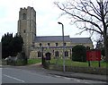
Living in CB6 1GH means being part of a small, tightly knit residential cluster in Littleport, a village in East Cambridgeshire. The area covers just 1.1 hectares, housing 1,793 people in a densely populated setting with 1,716 residents per square kilometre. Its proximity to the River Great Ouse and the A10 road links it to nearby towns like Ely, six miles to the south. Historically, Littleport was a hub for eel fishing and manufacturing, with ties to figures like William Harley, father of the Harley-Davidson founder. Today, the village retains a quiet, rural character, with landmarks such as the Adams Heritage Centre, a Grade II-listed ironmonger’s shop, and a low trig point near Little Ouse. The community is defined by its compact size and mix of historical and modern elements, offering a peaceful yet connected lifestyle. Residents benefit from nearby rail links and a strong sense of local identity, shaped by centuries of trade and industry.
- Area Type
- Postcode
- Area Size
- 1.1 hectares
- Population
- 1793
- Population Density
- 1716 people/km²
The property market in CB6 1GH is characterised by a high rate of home ownership—74%—indicating a strong preference for owner-occupied housing. The area is composed almost entirely of houses, with no mention of flats or apartments in the data. This suggests a housing stock that caters to families and individuals seeking more space, typical of rural or semi-rural settings. Given the small area size of 1.1 hectares, the number of properties is limited, which may make the market competitive for buyers. The compact nature of the area means that properties are likely to be in close proximity to local amenities, such as the Littleport railway station and nearby retail outlets. For those considering the area, the focus on owner-occupied homes implies a stable, long-term community, though the limited housing stock may require buyers to look beyond CB6 1GH for additional options.
House Prices in CB6 1GH
Showing 30 properties
| Address | Type | Beds | Baths | Last Sale Price | Last Sale Date | |
|---|---|---|---|---|---|---|
| 3 Rye Close, Littleport, CB6 1GH | Terraced | 3 | 1 | £238,000 | Aug 2022 | |
| 19 Rye Close, Littleport, CB6 1GH | house | - | - | £273,500 | Apr 2021 | |
| 23 Rye Close, Littleport, CB6 1GH | Semi-detached | 3 | 2 | £225,000 | Feb 2021 | |
| 2 Rye Close, Littleport, CB6 1GH | Terraced | 4 | 2 | £265,000 | Feb 2020 | |
| 5 Rye Close, Littleport, CB6 1GH | Terraced | 3 | 1 | £210,000 | Nov 2019 | |
| 25 Rye Close, Littleport, CB6 1GH | house | 3 | - | £236,000 | Apr 2019 | |
| 9 Rye Close, Littleport, CB6 1GH | Semi-detached | 4 | 2 | £289,950 | Nov 2016 | |
| 35 Rye Close, Littleport, CB6 1GH | house | 5 | 3 | £362,500 | Mar 2016 | |
| 37 Rye Close, Littleport, CB6 1GH | Semi-detached | 4 | 2 | £274,000 | Feb 2016 | |
| 1 Rye Close, Littleport, CB6 1GH | Terraced | 3 | - | £280,000 | Dec 2015 |
Energy Efficiency in CB6 1GH
The lifestyle in CB6 1GH is shaped by its proximity to a range of practical amenities. Within reach are five retail outlets, including Co-op Main, Co-op Wisbech, and M&S Littleport BP, offering everyday shopping needs. The area’s rail network, with stations at Littleport, Ely, and Shippea Hill, provides easy access to broader transport links, whether for commuting or leisure trips. While the data does not specify parks or leisure facilities, the village’s historical and cultural landmarks—such as the Adams Heritage Centre and the Harley-Davidson statue—add character to daily life. The compact nature of the area means that amenities are closely clustered, reducing the need for long journeys. This balance of practical retail, transport options, and local heritage creates a convenient, community-focused lifestyle for residents.
Amenities
Schools
The primary school nearest to CB6 1GH is Littleport Community Primary School, which holds an Ofsted rating of ‘good’. This school serves the local community, providing education for younger children in the area. The absence of secondary schools in the immediate vicinity means that families may need to consider commuting to nearby towns for secondary education. However, the ‘good’ rating at the primary level suggests a solid foundation for early education, which is a key factor for families prioritising school quality. The presence of a single primary school also indicates that the area’s educational infrastructure is tailored to the needs of a small, residential community. For parents, this means a manageable local option for younger children, though additional planning may be required for older students.
| Rank | School | Type | Entry gender | Ages |
|---|
Explore more schools in this area
Go to Schools tabDemographics
The population of CB6 1GH has a median age of 47, with the majority of residents aged between 30 and 64. This suggests a mature, stable community with a focus on established households. Home ownership is high, at 74%, reflecting a preference for long-term residency over rental properties. The area is predominantly composed of houses, rather than flats or apartments, which aligns with the higher proportion of owner-occupied homes. The predominant ethnic group is White, though specific data on diversity is not provided. The age profile indicates a population that is largely in their prime working years, which may influence local services and amenities. The density of 1,716 people per square kilometre suggests a compact, closely connected community, though the small area size means resources and infrastructure are concentrated within a limited radius.
Household Size
Accommodation Type
Tenure
Ethnic Group
Religion
Household Composition
Age
Household Deprivation
NS-SEC
Explore more demographic insights in this area
Go to Demographics tabPlanning
Planning Constraints
- Flood RiskPremium
- Ramsar Wetland SitesPremium
- Area of Outstanding Natural BeautyPremium
- Protected Nature ReservePremium
- Protected WoodlandPremium