Area Overview for CB5 0JW
Photos of CB5 0JW

Area Information
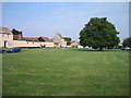
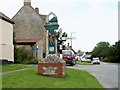
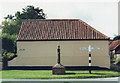
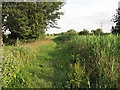
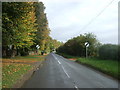
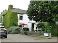
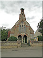
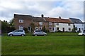
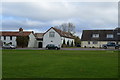
CB5 0JW is a small, tightly knit residential postcode in East Cambridgeshire, encompassing parts of the historic village of Reach. With a population of just 2051 and a low density of 50 people per square kilometre, it retains a quiet, rural character. The area sits at the northern end of the Devil’s Dyke earthwork, a historic landscape feature, and is linked to Reach Lode, a waterway that once facilitated trade. This is a place of enduring heritage, with roots tracing back to Roman times and medieval markets granted by King John in 1201. The village is served by nearby railway stations, including Waterbeach and Newmarket, offering connections to Cambridge and beyond. Daily life here balances historical charm with modern amenities, from local primary schools to nearby retail hubs. The community is predominantly middle-aged, with a strong focus on home ownership, reflecting a stable, family-oriented environment. For those seeking a peaceful, low-density area with historical depth, CB5 0JW offers a unique blend of tradition and practicality.
- Area Type
- Postcode
- Area Size
- Not available
- Population
- 2051
- Population Density
- 50 people/km²
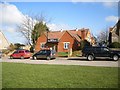
The property market in CB5 0JW is characterised by a high rate of home ownership (68%) and a predominance of houses over flats or other accommodation types. This suggests a community where property is viewed as a long-term asset, with a focus on family homes rather than rental properties. The low population density and small postcode area mean the housing stock is limited, with fewer options for buyers compared to larger urban areas. However, the presence of nearby villages and towns, such as Swaffham Prior and Burwell, may provide additional choices for those seeking to expand their search. The emphasis on houses indicates a demand for spacious, private living, which aligns with the rural setting. For buyers, this means a market that prioritises stability and permanence, though the limited local supply may require considering adjacent areas for more options. The absence of significant rental activity also suggests a lower turnover of properties, reinforcing the area’s quiet, established nature.
House Prices in CB5 0JW
No properties found in this postcode.
Energy Efficiency in CB5 0JW
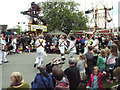
The lifestyle in CB5 0JW is shaped by its proximity to retail and transport hubs. Within practical reach are five retail venues, including Co-op Burwell, Asda Burwell, and M&S One Thousand Guineas BP, providing access to everyday shopping needs. These stores cater to a range of requirements, from groceries to fuel, supporting a self-sufficient local economy. The area’s five railway stations, such as Waterbeach and Newmarket, offer convenient connections to larger towns and cities, enhancing mobility for commuters and visitors. While the data does not mention parks or leisure facilities, the historical significance of Reach—such as the annual Reach Fair and medieval ruins—adds cultural depth to daily life. The combination of retail access and transport links ensures that residents can easily access services without needing to travel far. This balance of practicality and heritage contributes to a lifestyle that is both convenient and rooted in tradition.
Amenities
Schools
The schools nearest to CB5 0JW include Swaffham Prior Church of England Primary School and Swaffham Bulbeck Church of England Primary School, both of which hold Ofsted ratings of ‘good’. These are the only schools listed in the data, and both are primary institutions, serving children aged 4 to 11. The presence of two primary schools within the area offers families options for early education, though secondary schooling would require commuting to nearby towns. The ‘good’ Ofsted ratings indicate that these schools meet national standards in teaching quality and student outcomes. For families prioritising primary education, the proximity of these schools is a significant advantage. However, the absence of secondary schools in the immediate vicinity means that parents must factor in travel time and costs for older children. The school mix reflects the area’s focus on younger families, with a strong local network for early education.
| Rank | School | Type | Entry gender | Ages |
|---|
Explore more schools in this area
Go to Schools tabDemographics
The demographic profile of CB5 0JW is defined by a median age of 47, with the majority of residents aged between 30 and 64. This suggests a mature, settled community, likely with strong family ties and long-term residency. Home ownership rates are high at 68%, indicating a preference for property as a long-term investment. The accommodation type is predominantly houses, aligning with the rural, low-density nature of the area. The predominant ethnic group is White, though specific diversity data is not provided. The population density of 50 people per square kilometre reinforces the area’s spacious, uncluttered character. This profile suggests a community focused on stability, with fewer transient residents. The age range also implies a demand for schools and local services tailored to families, which is reflected in the presence of two primary schools nearby. The low population density and high home ownership further indicate a lack of pressure on housing and infrastructure, contributing to a relaxed quality of life.
Household Size
Accommodation Type
Tenure
Ethnic Group
Religion
Household Composition
Age
Household Deprivation
NS-SEC
Explore more demographic insights in this area
Go to Demographics tabPlanning
Planning Constraints
- Flood RiskPremium
- Ramsar Wetland SitesPremium
- Area of Outstanding Natural BeautyPremium
- Protected Nature ReservePremium
- Protected WoodlandPremium