Area Overview for CB3 9DT
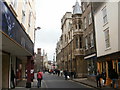
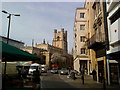
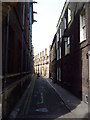
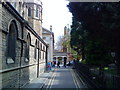
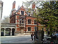
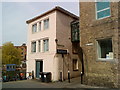
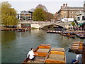
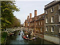
Photos of CB3 9DT
Area Information
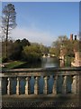
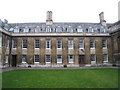
Living in CB3 9DT offers a distinct experience within the Cambridgeshire landscape. This postcode covers a specific residential cluster with a population of 5,735 people. The area sits partly within the Cambridge town boundary and partly within the parish of Grantchester, creating a unique identity that sits between urban and rural settings. Historically, Newnham was not a unified parish but operated outside the conventional parish system until 1918. Early development began in the 19th century with the construction of No. 3 Summerfield in 1868, followed by rapid middle-class growth. This heritage continues today in the form of the Newnham Croft, which became part of the borough of Cambridge in 1911. The location benefits from proximity to the West Cambridge Conservation Area, which includes a section designated as Old Newnham and Queen's Road. Residents enjoy access to recreational spaces with historical significance, such as Lammas Land and Grantchester Meadows. These paddocks were originally vast marshy common land used for grazing. Newnham's position on the west bank of the River Cam provides a setting that balances quiet living connectivity to the wider city.
- Area Type
- Postcode
- Area Size
- Not available
- Population
- 5735
- Population Density
- 1510 people/km²
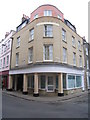
The property market in CB3 9DT is characterised by a predominance of houses and a strong culture of home ownership. With 57% of residents owning their homes, the area leans heavily towards owner-occupiers rather than a high-density rental market. This statistic indicates that you are likely to purchase a property that has been tended to by a long-term family rather than a transient tenant. The primary accommodation type listed for the area is houses, which suggests a preference for detached or semi-detached structures over flats. This housing stock supports families and long-term residents who value privacy and space. The historical context of the area, including rapid middle-class development in the 19th and 20th centuries, contributes to a stock of established homes. When considering homes in CB3 9DT, you are entering a market where stability is common. The specific postcode cluster represents a small residential area where property values reflect the desire for a permanent base. Buyers can expect a traditional suburban feel with significant stock available for purchase.
House Prices in CB3 9DT
No properties found in this postcode.
Energy Efficiency in CB3 9DT
Residents of CB3 9DT enjoy convenient access to a variety of retail, rail, and airport amenities. For daily shopping needs, you are within practical reach of five key retail venues. Notable options include the Co-op Grantchester, Tesco Petty, and M&S Cambridge. These stores provide essential goods and fresh food without requiring long journeys. Transport links are equally convenient with four rail stations nearby. You can easily reach Cambridge North Railway Station, Shelford Railway Station, and Waterbeach Railway Station. These stations offer connections to the wider network, facilitating easy travel to Cambridge city centre or other parts of the region. For business trips or holidays, two airports are listed as nearby amenities, specifically Cambridge Airport. This variety of transport choices gives you flexibility for commuting or leisure travel. The combination of retail variety and multiple transport nodes creates a lifestyle that balances suburban quiet with urban convenience. Your daily errands are handled within a short radius.
Amenities
Schools
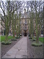
Families considering CB3 9DT have access to two highly regarded independent schools in the immediate vicinity. The nearest educational institutions are King's College School and St John's College School. Both schools operate under the independent type classification, offering private education options. The independent status of these institutions suggests they cater to families seeking bespoke educational approaches and smaller class sizes. While the data does not specify Ofsted ratings for these specific entries, their inclusion in the nearby schools list confirms their established presence and local recognition. This mix of independent provision means you do not have state schools listed as immediate neighbours in the provided dataset. For parents looking for alternatives to the state sector, these two colleges offer a prestigious route for their children. The presence of such specific institutions indicates a neighbourhood that values high-quality education. Residents who prioritise independent schooling will find these colleges within a practical commuting distance.
| Rank | School | Type | Entry gender | Ages |
|---|
Explore more schools in this area
Go to Schools tabDemographics
The community in CB3 9DT is defined by a very young population profile. The median age is 22 years, with young adults aged between 15 and 29 representing the most common age range. This demographic structure suggests an area highly active with students, young professionals, and recent graduates. Despite the youthful median age, there is a mixed housing tenure landscape. Home ownership stands at 57%, indicating that the majority of residents owning their properties outright or with a mortgage rather than renting. This suggests a relatively stable local population alongside the younger demographic. The predominant ethnic group is White, reflecting the broader demographic trends of the region. The area features houses as the primary accommodation type, which aligns with the presence of home owners rather than large-scale high-density rental blocks. With a population density of 1,510 people per square kilometre, the neighbourhood maintains a moderate density that supports a mix of private gardens and shared community spaces without feeling overcrowded.
Household Size
Accommodation Type
Tenure
Ethnic Group
Religion
Household Composition
Age
Household Deprivation
NS-SEC
Explore more demographic insights in this area
Go to Demographics tabPlanning
Planning Constraints
- Flood RiskPremium
- Ramsar Wetland SitesPremium
- Area of Outstanding Natural BeautyPremium
- Protected Nature ReservePremium
- Protected WoodlandPremium