Area Overview for CB3 7AH
Photos of CB3 7AH
Area Information
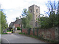
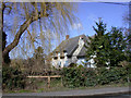
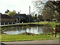
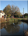
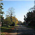
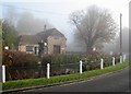
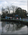
CB3 7AH represents a specific residential cluster within the historic village of Barton, situated in the South Cambridgeshire district. This small community sits approximately four miles south-west of Cambridge, near junction 12 of the M11 motorway. The area encompasses a population of 1,475 people living at a density of 87 people per square kilometre. Historical records indicate the settlement dates back to the Domesday Book of 1086, having been established on the line of the Roman road Akeman Street. Today, the locality retains a rural character defined by thatched cottages, listed buildings, and a village pond, all while maintaining convenient access to the wider Cambridge region. The postcode covers a tight-knit environment where modern commuter needs meet deep-rooted agricultural and architectural heritage. Residents live close to the M11, which provides a direct link to London, yet the village itself remains distinct from the urban sprawl. The population reflects a mature demographic, with a median age of 47 years. Living in this postcode means residing in an area where ST Peter's Church and the Countryside Restoration Trust headquarters define the local landscape. The mix of historic properties and green spaces creates a setting that appeals to those seeking a quieter life without complete isolation.
- Area Type
- Postcode
- Area Size
- Not available
- Population
- 1475
- Population Density
- 87 people/km²
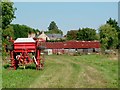
Homes in CB3 7AH are primarily characterised by traditional house types rather than flats or modern apartments. With 73% of residents owning their homes, the market functions largely as an owner-occupied sector. This high ownership rate suggests a preference for stability and long-term investment over renting. The accommodation type data confirms that houses dominate the local housing stock, aligning with the village's historical development. Buyers looking at this small postcode area should expect a range of properties, including the historic thatched cottages and listed buildings found along the high streets. The presence of large estates like Burwash Manor Barns indicates a diversity in property styles, from historic farm conversions to residential houses. Given the rural setting and proximity to the M11 motorway, properties often cater to commuters working in Cambridge or beyond. The relatively low population of 1,475 means that property transactions are less frequent than in major cities, potentially allowing for more negotiation leverage. The area caters well to those seeking a rural lifestyle with access to major transport networks. Prospective buyers will find a market that values heritage and space over high-density urban living.
House Prices in CB3 7AH
No properties found in this postcode.
Energy Efficiency in CB3 7AH
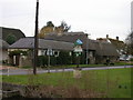
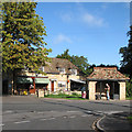
Residents of CB3 7AH benefit from a variety of amenities within practical reach, blending rural charm with commercial convenience. Retail options include Sainsburys Cambridge, Co-op MRMF, and Waitrose Cambridge, offering a comprehensive range of groceries and daily necessities. For leisure and dining, The Hoops pub, dating back to 1776, serves as a central social hub dating from the late 18th century. Visitors and locals also frequent Burwash Manor Barns, a country shopping complex that features a butcher, grocer, and tea rooms. Transport links are supported by four nearby railway stations, including Shelford, Foxton, and Shepreth, facilitating travel to Cambridge and beyond. Two airports, both Cambridge Airport, provide air travel opportunities for those needing to fly. The village itself features a pond, recreation ground, and several listed buildings such as Bird's Farm and Dale's Barn. The Countryside Restoration Trust headquarters adds cultural value with its woodland burial ground and glebe plantings. Daily life balances the quiet of the village with easy access to broader commercial and transport networks.
Amenities
Schools
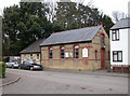
Families residing in CB3 7AH have access to a specific selection of educational institutions nearby. Coton Church of England Voluntary Controlled Primary School operates as a state-funded primary school with an Ofsted rating of satisfactory. For independent education, Madingley School serves as a secondary option, offering a private schooling alternative for families with the means. Madingley Pre-Preparatory School provides an independent education route for younger children prior to their transition to secondary levels. This mix of state and independent options means parents can choose public education close to the village or private schooling if preferred. The proximity of these institutions makes living in CB3 7AH viable for families without the need to travel long distances to Cambridge city centre for education. The variety of school types supports different educational philosophies and budget levels. Local families often utilise the local primary school before moving on to either the nearby independent schools or further education elsewhere. The specific naming of these venues ensures clarity for anyone researching the educational infrastructure serving this postcode.
| Rank | School | Type | Entry gender | Ages |
|---|
Explore more schools in this area
Go to Schools tabDemographics
The community within CB3 7AH is defined by a mature population structure. The median age stands at 47 years, confirming that adults between the ages of 30 and 64 constitute the most common age range. This demographic profile suggests a stable household base rather than a transient student or young professional focus. Residential patterns reflect long-term settlement, with home ownership levels reaching 73%. This high proportion indicates that the majority of residents own their properties outright or with a mortgage, rather than renting. The predominantly White ethnic group forms the largest demographic segment of the population. Accommodation in the area consists almost entirely of houses, distinguishing it from urban districts characterised by apartment blocks. The low density of 87 people per square kilometre further emphasises the spacious nature of the living environment. These figures paint a picture of a settled community where families or retired couples reside in substantial homes. The lack of rental data implies a market driven by local purchase or inheritance rather than private or social housing sectors. Such statistics are typical of established villages where generations have lived within the boundaries. The area does not attract short-term lets or mobile populations due to its nature and location.
Household Size
Accommodation Type
Tenure
Ethnic Group
Religion
Household Composition
Age
Household Deprivation
NS-SEC
Explore more demographic insights in this area
Go to Demographics tabPlanning
Planning Constraints
- Flood RiskPremium
- Ramsar Wetland SitesPremium
- Area of Outstanding Natural BeautyPremium
- Protected Nature ReservePremium
- Protected WoodlandPremium