Area Overview for CB22 4FW
Photos of CB22 4FW
Area Information
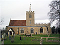
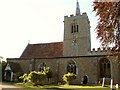
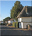
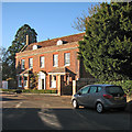
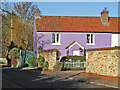
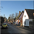
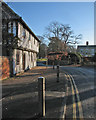
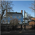
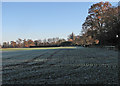
Living in CB22 4FW, a small residential cluster in South Cambridgeshire, offers a quiet, village-like atmosphere with a strong sense of community. Situated near the River Granta, the area is part of the historic parish of Whittlesford, known for its medieval roots and proximity to Cambridge. With a population of 1,237 and a density of 396 people per square kilometre, it balances intimacy with practicality. The area’s character is shaped by its historic infrastructure, including Whittlesford Parkway Railway Station, which connects residents to Cambridge and London. Daily life here is defined by easy access to local amenities, a low crime rate, and a predominantly owner-occupied housing stock. The village’s conservation area, designated in 1972, preserves its medieval core, while nearby sites like the 13th-century church and former mill add historical depth. CB22 4FW is ideal for those seeking a tranquil, well-connected environment with minimal urban pressures.
- Area Type
- Postcode
- Area Size
- Not available
- Population
- 1237
- Population Density
- 396 people/km²
The property market in CB22 4FW is dominated by owner-occupied homes, with 73% of properties owned outright. This suggests a stable market with limited rental activity, typical of smaller, historic villages. The accommodation type is predominantly houses, reflecting the area’s rural character and lack of high-density development. Given the small population and limited land area, the housing stock is likely to be modest in scale, with few new builds. Buyers should consider the area’s size and its proximity to Cambridge for additional property options. The high home ownership rate indicates a community of long-term residents, which may influence market dynamics. For those seeking a traditional, low-maintenance home with historical charm, CB22 4FW offers a niche opportunity.
House Prices in CB22 4FW
No properties found in this postcode.
Energy Efficiency in CB22 4FW
The lifestyle in CB22 4FW is defined by its blend of historic charm and practical amenities. Nearby retail options include Spar, Co-op Sawston, and M&S Whittlesford Cambridge BP, offering everyday shopping needs. The area’s rail connections provide access to larger towns for dining, entertainment, and specialist services. The village’s conservation status preserves its medieval character, with landmarks like St Andrew and St Mary Church and King George’s Field adding to its appeal. While the immediate area lacks large leisure facilities, the proximity to Cambridge ensures access to cultural and recreational opportunities. The low population density means a quieter, more relaxed pace of life, ideal for those prioritising tranquillity over urban vibrancy.
Amenities
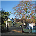
Schools
The nearest school to CB22 4FW is William Westley Church of England VC Primary School, a primary school with a good Ofsted rating. This institution serves the local community, providing education for younger children within the village. The absence of secondary schools in the immediate vicinity means families may need to look further afield for secondary education, potentially in nearby towns like Cambridge or Sawston. The presence of a well-rated primary school is a key draw for families, ensuring accessible early education. The school’s status as a Church of England institution may appeal to those seeking faith-based schooling, though no data on religious affiliation is provided.
| Rank | School | Type | Entry gender | Ages |
|---|
Explore more schools in this area
Go to Schools tabDemographics
The community in CB22 4FW is predominantly composed of adults aged 30–64, with a median age of 47. Home ownership rates are high at 73%, reflecting a stable, long-term resident base. The area is characterised by houses rather than flats, aligning with its rural and semi-rural setting. The predominant ethnic group is White, though specific diversity metrics are not detailed in the data. The low population density of 396 people per square kilometre suggests a spread-out, low-rise residential layout. This demographic profile indicates a mature, settled population, likely with established careers and family ties. The absence of significant deprivation data means the area appears to support a quality of life with access to services and low environmental risks.
Household Size
Accommodation Type
Tenure
Ethnic Group
Religion
Household Composition
Age
Household Deprivation
NS-SEC
Explore more demographic insights in this area
Go to Demographics tabPlanning
Planning Constraints
- Flood RiskPremium
- Ramsar Wetland SitesPremium
- Area of Outstanding Natural BeautyPremium
- Protected Nature ReservePremium
- Protected WoodlandPremium